
Qld weather: Storms rip through Brisbane and SEQ
Brisbane felt the wrath of an intense storm last night with heavy rain, 35km/h wind gusts reported across the city with thousands of residents in SEQ losing power after a 35C heatwave.
QLD weather news
Don't miss out on the headlines from QLD weather news. Followed categories will be added to My News.
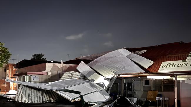
Brisbane has been hammered by an “intense microburst” that ripped a roof off a building in New Farm and while hail was reported across the city.
The heritage-listed Officers Mess in New Farm was subject to what some described as a “mini tornado” where the roof was blown off from one side of the building to the other.
Hail was reported in Brisbane CBD including parts of Bowen Hills and Lutwyche following the “intense microburst”.
The Bureau of Meteorology recorded 35km/h wind gusts across Brisbane at the time the roof collapsed.
More than 10,000 households across the south east have lost power thanks to the severe storms, following Friday’s extreme heatwave.
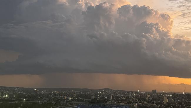
The storm, which formed along a trough line and southeast wind change, began near the Gold Coast border before sweeping north through Brisbane before heading north towards Rockhampton, according to Bureau of Meteorology meteorologist Shane Kennedy.
“The storm started up near the border around the Gold Coast in the evening, then travelled north along that wind change through the southeast, including Brisbane suburbs. It weakened a little bit over the city so there weren’t any warnings for the Sunshine Coast as it weakened as it moved through there, but we had that line continue to track north, even producing more storms up around that Hervey Bay area as well, and then Bundaberg,” Mr. Kennedy said.
At 7.40pm the Bureau warned the severe thunderstorm was detected near Woodridge and Sunnybank Hills and would continue moving north. It reached Brisbane CBD, Aspley, Boondall and Sandgate by 8.10pm and Strathpine, Redcliffe, Deception Bay waters and Beachmere by 8.40pm.
On Saturday, the weather bureau has forecast maximum temperatures of 31C, with a 5 per cent change of rain.
As of 5.50am, storms have not been forecast.
It comes after power was lost to thousands of residents after a 107km/h wind gust ripped through Outback towns.
The storm followed a sweltering day of record-breaking temperatures across the region, with several areas experiencing conditions well above average.
“Temperatures were four to seven degrees above average in the southeast,” meteorologist Shane Kennedy said.
“Brisbane city was 35.5C, and Sunshine Coast Airport was 36.2C and that was seven above average there.”
Coolangatta recorded 32.7C, its hottest January day since 2018, while Toowoomba and Warwick reached 34 and 36C, respectively.
Meanwhile, Winton Airport in western Queensland hit a scorching 45.8C, marking its hottest January day since 2014.
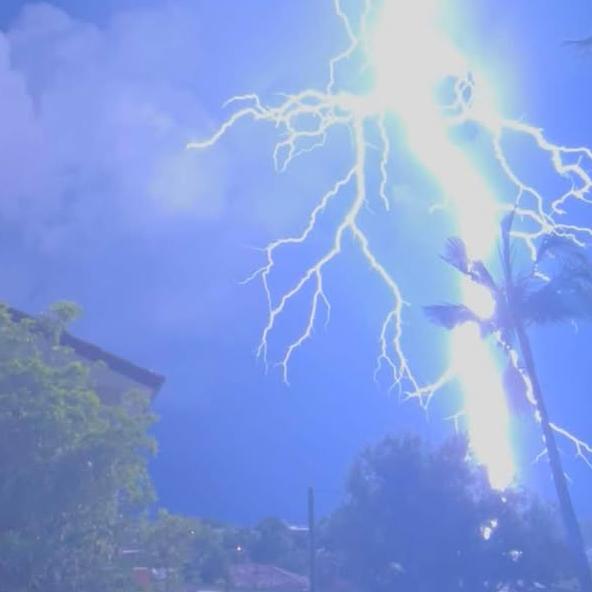
More than 80,000 lightning strikes had been recorded in SEQ up until 8.30pm.
An Energex spokesperson confirmed there was storm damage to some areas of the south east, including fallen powerlines.
This has resulted in 7,869 SEQ residents to be without power more than an hour after storms began lashing the area.
The majority of which came from Brisbane City Council areas and Logan with a combined 6,964 customers without power at 8.30pm.
In Ipswich, 300 customers remained without power after more than 2000 were hit during the storms.
“Energex crews are responding, but when there is lightning they need to wait until conditions ease,” the Energex spokesperson said.
“Restoration timeframes will depend on damage assessments and Outage Finder will be updated accordingly.
“We are keeping a close eye on weather warnings and we urge our customers to do likewise, so they can stay safe and be prepared for power outages.”
10,731 Energex customers across the south east were without power at 7.45pm, with the bulk in the Brisbane City Council areas.
5,556 were without power throughout Brisbane City, 2,171 in Ipswich and 2,648 without power in Logan.
The Luke Combs concert at Suncorp stadium faced delays with crowds initially told to clear the venue. After taking shelter from the storm, there was relief when the crowd was able to return a short time later.
The Bureau of Meteorology warns that severe thunderstorms likely to produce damaging winds, large hail and heavy rainfall that may lead to flash flooding were detected near Tamborine and Jimboomba.
x
Meanwhile, more 7000 properties were without power in Blackwater, Emerald, Cloncurry and Clermont on Friday night after storms ripped through.
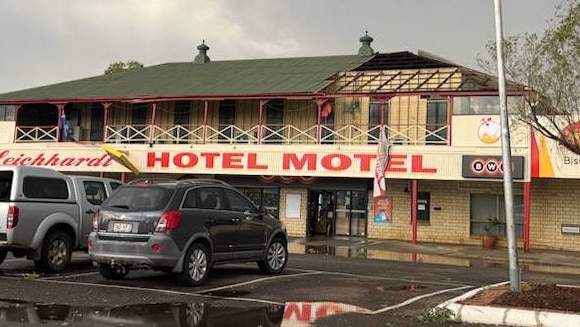
The Leichhardt Hotel had part of its roof ripped off this afternoon when the storm front passed through.
One of the employees at the hotel told The Courier-Mail the storm only lasted 20 minutes, but it was “quite crazy” but that nobody was injured.
The hotel remains open for takeaway and counter service in the main bar.
A gust of 104km/h was recorded at Emerald at 4.34pm and a 94km/h gust at Blackwater at 5.04pm.
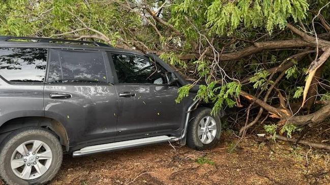
Images posted to Higgins Storm Chasing show damage to the roof of the Leichhardt Hotel Motel at Cloncurry, and a 4WD vehicle under a tree.
It comes after another hot day across Queensland.
The mercury rose to 35.5C in Brisbane but the city was still stifling late in the afternoon, with an apparent temperature of 39.4C after 6pm.
The highest temperature across the state was at Winton, where the mercury hit 45.8C just after 3pm. It was still a stifling 42.8 at 6.20pm

‘Bomb cyclone’ as Qld faces damaging winds, freezing temps
A wild cold front is set to blast southern Queensland over coming days with damaging winds and subzero temperatures, amid the potential for a “bomb cyclone” in northern NSW.

Frost, unseasonal rain expected for parts of Qld
Rain, frosty temperatures and big swells are set to ruin the start of the school holidays across the southeast and central Queensland, the weather bureau has warned.