
Greater Adelaide Regional Plan forecasts population of 2.2m within 30 years
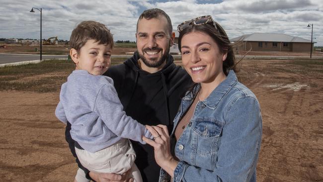
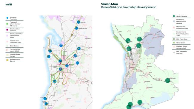
Higher-density living along key urban corridors and new greenfields developments ringing the city are the core of a new 30-year master plan for Adelaide. See it here.

SA News
Don't miss out on the headlines from SA News. Followed categories will be added to My News.
Apartments and higher density housing are earmarked along major roads and public transport centres in a 30-year plan to boost Adelaide’s population to 2.2m and add more than 300,000 homes.
Pitched as a blueprint to make homes more affordable and prevent further supply shocks, the Greater Adelaide Regional Plan pinpoints northern Adelaide and Murray Bridge as twin engine rooms of growth as an urban growth boundary is ditched.
Controversial infill development spread across the suburbs is sidelined as Housing Minister Nick Champion concedes this is starting to overload parking, stormwater drains, sewerage and traffic.
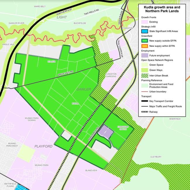
Seven new greenfield growth areas are targeted for 96,000 homes over the next 30 years. Four of these in the north, at Two Wells, Roseworthy, Riverlea and Kudla.
More than 100,000 homes, or 36 per cent of Adelaide’s housing target growth to 2051, are earmarked for the north – 22 per cent, or 70,000 homes are in Adelaide’s outer north alone.
A new linear park of more than 500ha is planned to run from the Hills face at Uleybury, through Evanston Gardens and along the Gawler River.
The 30-year plan charts 14 “strategic infill sites” for higher density homes, including Elizabeth, Port Adelaide, Noarlunga, Paradise Interchange, Unley Rd and the Norwood Parade.
This involves focusing on major suburban centres and main roads with existing infrastructure, along with reviving the transit-oriented developments (TODs) proposed by the Rann Labor government, that resulted in the Bowden precinct.
In an interview with The Advertiser, Mr Champion said the document was “a long-term plan to prevent future housing shocks and future housing crises”.
“If we want to keep rents low, if we want to keep housing affordability within the grasp of the next generation, we have to start planning now,” he said.
“Rents are going up and housing prices are going up. The only thing that can fix those two things is supply in the short, medium and long-term.”
The 30-year-plan, to be released on Monday for consultation, replaces a planning blueprint first released in 2010. It includes:
FORECASTS for an extra 315,000 houses and 254,000 jobs, supporting an extra 670,000 residents of greater Adelaide – a 46 per cent increase on today’s population of 1.5m.
LIMITING housing growth in Adelaide’s outer south to 22,000 homes, or just seven per cent of the 2051 target.
ENCOURAGING more retirement living options, including duplexes, small-scale apartments, build-to-rent schemes and terraces.
REDEVELOPING former industrial land in “state significant precincts” in areas such as Thebarton (former brewery), Keswick (Le Cornu) and Kent Town/Stepney.
ADELAIDE’S central business district pinpointed for high-density apartments and playing “a more important role in delivering convenient and affordable” homes.
MAJOR growth area infrastructure and planning, for developments including Concordia and Roseworthy, to be spearheaded by the state government.
SEE THE FULL PLAN HERE
Mr Champion cited the billion-dollar redevelopment of Thebarton’s 8.4ha former West End Brewery site, where 1000 homes are proposed, as a key example of “strategic infill”.
“We know that previous incarnations of the plan probably had an over-reliance on general infill in existing communities,” he said.
“It’s now starting to create infrastructure costs in existing suburbs, around stormwater, tree canopy, sewerage, traffic and the like.
“What we want to do is focus on areas of housing supply that can bring us good results with greater densities and greater housing outcomes, but that are better planned and better able to be digested by the city.”

The 30-year blueprint follows Premier Peter Malinauskas in June revealing average water bills would rise by $85 annually to fund a $1.5bn water and sewer infrastructure surge to unlock 40,000 home allotments within four years.
Unveiling his Housing Road Map, Mr Malinauskas labelled water and sewerage connection failures to Adelaide’s growing north a “public policy disaster”, saying $1.2bn of the record spend would fund connections to northern greenfield developments.
At the time, the Opposition said Mr Malinauskas’s announcement of the largest single release of residential land in the state’s history, made in February last year, appeared to be in “complete and utter tatters” because of inadequate water and sewer connections.
That land release comprised parcels for 10,000 homes each at Dry Creek and Concordia (on Gawler’s northeastern fringe), at least 2000 homes at Hackham and 1700 at Sellicks Beach.
MURRAY BRIDGE TO BE SA’S ‘SECOND CITY’
Murray Bridge is earmarked as South Australia’s major regional city with “significant long-term growth opportunities” for greenfield housing development to ease a critical shortage.
The riverbank city of 22,000 people is among seven growth areas identified in the Greater Adelaide Regional Plan, which says they can accommodate about 96,000 homes over the next 30 years.
Another four are in Adelaide’s north, while the remainder are existing south coast growth areas, at Victor Harbor and Goolwa.
The dormant former multifunction polis site at Gillman is slated for industrial growth, particularly for the expanding defence industry, with citywide demand for 4900ha of employment land forecast to 2051.

Housing and Urban Development Minister Nick Champion said huge industrial developments at Murray Bridge, like Thomas Foods International’s meat processing facility, meant many future residents would not have to commute to Adelaide along the South Eastern Freeway.
“There’s big industry up there that needs workers, and when industry needs workers, workers need housing,” he said.
“This will be an opportunity where people can work locally. They don’t have to get on the freeway to commute to the city. Inevitably, there’ll be some commuters but that won’t be the orientation of the town.
“It’ll have its own economy and people will live and work locally, and live on the river. People won’t want to come to Adelaide because they’ll be able to go skiing on the weekend.”
Thomas Foods International managing director Darren Thomas told an Advertiser Bush Summit in 2023 that a dire housing shortage had forced his firm to intervene to find staff.
A bold $7.5bn plan to create a satellite city of 17,100 new homes for 44,000 residents, near Murray Bridge, was unveiled by developers in July.
Mr Champion said Murray Bridge could overturn a historic population concentration in Adelaide and follow the growth of regional cities interstate.
“It’s happening in Victoria already with the spectacular growth around Bendigo. Murray Bridge is the place outside of Adelaide where that’s most likely to happen,” he said.
“The local council have gone and had a look at what’s happened in Victoria and are very keen to make sure they’ve learned lessons from there and that they strategically plan for growth.”
He revealed a greenfield development Infrastructure Scheme would be implemented for the first time in Murray Bridge, under which a single committee would oversee construction of roads, drains, sewerage, water connections and other infrastructure.
The process will be supported by a Statewide Infrastructure Scheme Coordination Committee, for which a chief executive will be appointed within weeks.
Mr Champion said this aimed to stop the repeat of issues like tens of thousands of litres of sewage being trucked daily from northern Adelaide suburbs not connected to mains because of SA Water connection failures
“This new measure aims to prevent the problems we have seen in Angle Vale and Mount Barker, where critical infrastructure was left uncoordinated and underfunded,” he said.
More Coverage


Join the conversation

Police hunting wanted man in connection to Blackwood arson attacks
Police are calling on the public to help find an allegedly armed man wanted after two Blackwood arson attacks.
Read more

Mali’s flatpack solution to tackle housing crisis
In an attempt to solve the state’s housing crisis and deliver more homes faster, Premier Peter Malinauskas has unveiled a new Ikea like plan.
Read more