
Top 10 heaviest rainfall locations in NSW and Victoria in October
Was it a wet October for your farm? See which locations got the biggest drenching this month.
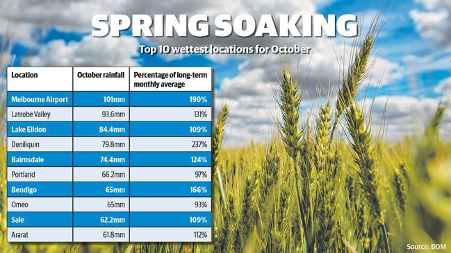
Spring rain has continued to fall across much of Victoria and southern NSW this week, with 17 out of 35 weather stations monitored by The Weekly Times already exceeding their long term October averages.
Topping the charts was Melbourne, which recorded 101mm so far this month, 190 per cent of its long term October average.
Deniliquin hit 237 per cent of its monthly average after heavy falls on Thursday and Friday brought its total to 79.8mm, and Bendigo reached 166 per cent with falls of 65mm.
Heavier rain early this month was topped by even heavier falls last week in some regions, with Bendigo, Mortlake and Lake Eildon recording more than half their monthly totals in the seven days to Monday.
Grain Growers chair Brett Hosking said the rain would help any green crops to fill and would help growers “finish off the season well”.
Meanwhile, late storms brought isolated reports of hail in Birchip and Ouyen this week.
Mixed grain farmer Craig Rickard said the hail hit his property 6km south of Birchip but was “not particularly severe”.
Agronomist Alistair Ferrier said the hail caused some damage to field peas but cereal crops on the property appeared to be unaffected.
Bureau of Meteorology duty forecaster Jonathan How said isolated showers would continue this week in some regions, with falls up to 20mm expected for areas east of Melbourne up to southeast NSW and across the Snowy Mountains and Southern Tablelands.
Growers could also expect temperatures to start warming, particularly across the Mallee and Murray regions, with temperatures in the high 20s to low 30s forecast for Thursday and Friday, he said.
‘Bring on autumn’: Farmers pin their hopes on a break
As temperatures soar in an old-fashioned summer, farmers across parts of southeast Australia are pinning their hopes on an early autumn break.
Where the rain fell in January
Rain has been scarce in a lot of places in Victoria at the start of 2025, but one region has been fortunate. We break down the best totals.