
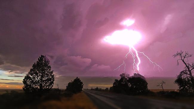
More storms on the way as Geelong cleans up damage
More storms are forecast for Victoria today ahead of a ‘brief reprieve’ for parts of the state on Saturday.

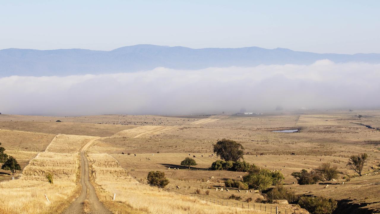
More storms are on the way for Victoria as residents in the state’s south west begin the clean-up from a night of damaging weather.
Bureau of Meteorology senior meteorologist Mark Anolak said he expected showers and thunderstorms to persist across Victoria today, particularly in the central parts of the state, including Melbourne.
Mr Anolak said the weather was expected to move east on Saturday, offering central parts of the state a “brief reprieve” before storms and humid conditions returned late in the weekend.
The humid conditions, caused by moist northerly winds, were “quite unusual” in Victoria, “particularly hanging around for this long”, he said.
The forecast comes as western parts of the state begin to clean up building damage from downed trees and flash flooding overnight.
Victoria’s State Emergency Service was still attending to dozens of calls for help in the Geelong area today.
Across the state the service had received almost 700 requests for assistance over the 24 hours to 11am Friday, with the majority of calls from the state’s south west.
Bit wet in Geelong tonight. Take care out there pic.twitter.com/ZwUgpe6IfG
— Anna🌸ðŸ‡ðŸ‡² (@Anna11608752) January 27, 2022
Power has now been restored to thousands of customers in Victoria’s west, after more than 20,000 lost power last night. More than 2000 remained without power as of 11am today, according to energy provider Powercor
AusNet reported nearly 500 customers without power in the state’s east due to unplanned outages, mainly in Melbourne’s outer northern suburbs.
From the storm last night in Geelong at mum’s. Only roof tiles damaged, luckily. pic.twitter.com/4NBrE0DsG5
— Titiana Booberini (@ebboob) January 27, 2022
Inverleigh, west of Geelong, received the highest rainfall total in the state over the past 24 hours, at 70.4mm.
Falls of 30-40mm were recorded across the west of the state.
Getting a little rain down here in Geelong Australia pic.twitter.com/WIctmDaCaq
— LightmyWheels (@LightmyWheels) January 27, 2022
5pm Thursday January 27 - Storm damage to SA roads will cost millions and take years to repair
Damage to roads from storms in South Australia this week is in the millions of dollars and could take years to repair.
District Council of Kimba chief executive Deb Larwood said she estimated damage in her council area on the Eyre Peninsula to be between $2 million and $5 million, but “probably closer to $5 million”.
“We’ve got about 400km of re-sheeted roads, and the top surface of the road has just been washed off,” she said.
Ms Larwood said 80 per cent of the 1700km of roads in the region had been impacted by the storms to some degree.
“We’ve got roads where a creek has washed through quite deep. There is no way a vehicle would get through,” she said.
Ms Larwood said it may take five years to fully repair the damage, and “once we know the full impact, it might be longer”, she said.
“It is going to be a long term fix. We’re asking everyone to be patient,” she said.
“We’re looking at all avenues of funding, because the amount we’re talking about is significant for a small council like us. Our revenue for this financial year is $4.3 million, and we’re talking millions in replacement.”
— Luke Moroney (@moroney_luke) January 26, 2022
Grain Producers Australia chief executive Brad Perry said some grain growers in the state were facing “a lot of damage and clean up” on their properties – some of which were hit with downpours of more than 300mm over the weekend.
But he said the damage to roads would be the biggest challenge for growers heading in to the next season.
“A lot of roads have washed into paddocks, and paddock top soil has washed on to roads. It’s a real mess,” he said.
Mr Perry said growers were having trouble accessing their properties due to the damage and may struggle to control weeds that come up after the rain.
He said more support was needed to make sure roads were accessible before seeding for next season’s grain crops started in April.
“Councils are going to need some assistance to get these roads back up and running,” he said.
But Mr Perry said overall the rain was good news for growers.
“This is rain that we wouldn’t normally get around this time. Being able to get a bit of moisture into the soil is really, really going to give growers good start for when they go to seed in April,” Mr Perry said.
Yesterday’s deluge causing havoc on a number of roads in the district. More water flowing today as the heavy rain continues. But....we have substantial subsoil moisture going into season 2022! pic.twitter.com/GDKw4vNahE
— Cherylynn Dreckow (@chez_dreckow) January 23, 2022
2pm Thursday January 27 - Mildura sets new record
Homes and businesses were inundated by flash flooding in Victoria’s north west overnight as emergency services responded to hundreds of calls for help.
Victoria State Emergency Services north west duty officer Rebecca McDonald said the serviced had received over 300 calls for assistance in the past 24 hours, including four from people trapped in floodwaters.
Volunteers at the SES Mildura Unit were heavily impacted, receiving 128 calls for help after more than 80mm of rain fell overnight, breaking daily January rainfall records.
“VICSES Mildura Unit volunteers responded to four requests for assistance from people trapped in their vehicle in floodwater,” Ms McDonald said.
“The volunteers were successfully able to rescue all the trapped persons, which is a great outcome but it could so easily have been a different story. We remind you never to drive through floodwater; it may be the last decision you make.”
Weatherzone reported 193,204 lightning strikes struck within a 200 km radius of Mildura between midday Wednesday and 9am Thursday in a storm that dumped about four times Mildura’s January average rainfall and notched up the town’s heaviest January daily rain total since records began.
Flash flooding affected mainly the Mildura CBD area and houses close to the Murray River.
Oh shit!! Just looked in my backyard!!! #Treedown#Flooded#Mildurapic.twitter.com/TOswVeW2Kl
— Charlie Bucket Alias ðŸ³ï¸â€ðŸŒˆðŸ³ï¸â€ðŸŒˆðŸ³ï¸â€ðŸŒˆ (@CharlieBBucket) January 26, 2022
This WATCH & ACT - FLASH FLOOD - Stay Indoors
— VicEmergency (@vicemergency) January 26, 2022
has been issued for Mildura and Surrounding areas.
Heavy rainfall is causing localised flash flooding.
You can stay safe by avoiding flooded and low-lying areas.
More details at https://t.co/Bohktv0K9fpic.twitter.com/jIJzc5EvdM
The Bureau of Meteorology issued a severe thunderstorm warning for the Mornington Peninsula and Western Port areas south east of Melbourne this morning as the storm front travelled west across the state.
The bureau warned heavy rainfall may lead to flash flooding in those areas.
Earlier today the storm travelled west across central Victoria, dumping heavy rain.
Malmsbury Headwall recorded 56.2mm in the 60 minutes to 5:15am.
Springhill-Tylden Road recorded 23mm in 30 minutes to 5:45am.
Trentham Reservoir recorded 38.6mm in 60 minutes to 6:00am.
Arthurs Creek has recorded 41.6mm in the hour to 8:02am and 57.8mm in the 2.5 hours to 8:41am
Coldstream has recorded 37.2mm in the hour to 8:46mm
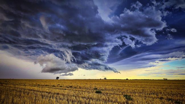
4pm Wednesday January 26 - Storm gives West Wimmera firefighters a reprieve
A storm front has arrived in Victoria from South Australia, dousing fires in the West Wimmera that have been flaring for weeks.
Mixed farmer and Poolaijelo fire captain Celia Scott said the rain had been a big relief after weeks attending to spot fires caused by burning tree stumps from a New Years blaze.
“It won’t have put fires out, but it will give us a reprieve for a few days,” she said.
Ms Scott said she had received 22mm of rain on her property. She said the rain would help to grow some feed for stock after the New Years fires damaged at least 18 properties and forced farmers to euthanise thousands of animals.
“It’ll help in some of the perennial pastures, but it won’t do much for annual. It’s too early,” she said.
She said the weather would also give fire recover charity BlazeAid and volunteer community members a boost after weeks spent “in 35 degree heat, ash and dust” replacing fences.
The storm front is now moving west across the state, and the Bureau of Meteorology has issued a severe thunderstorm warning for Victoria’s west on Wednesday afternoon.
The agency warned thunderstorms are likely to produce heavy rainfall that may lead to flash flooding and damaging winds in Mildura, Horsham, Warrnambool, Bendigo, Maryborough and Ballarat.
Horsham recorded a wind gust of 89 km/h at 2.48pm.
Natimuk received 19.4mm in the 30 min to 3.25pm
A sight for sore ash/dust filled eyes. Hopefully the beginning of the end of ppl having to hear Poolaijelo brigade call in re-ignitions of the NYE fires…..after 27 long, exhausting and draining days. Amazing community kindness shown and help given to us all pic.twitter.com/hUQngj0m52
— Celia Scott (@ArdmeenFarms) January 26, 2022
2pm Wednesday January 26
Western Victoria is bracing for severe thunderstorms from this afternoon as farmers in South Australia share images of flooded country and full dams.
Bureau of Meteorology meteorologist Jonathan How said the bureau expected to issue severe thunderstorm warnings every day this week as storms moved east from South Australia across Victoria, NSW and Tasmania.
Western Victoria would be the first to receive rain today, with thunderstorms and falls of up to 15mm forecast for the Victoria-South Australia border region.
“Heavy rain leading to flash flooding is the primary threat (from storms over the coming week),” Mr How said. “Damaging winds and large hail are also possible.”
Meanwhile humid weather is continuing this week, causing headaches for grape and stone fruit growers.
In grape growing areas, horticultural information service GrowCare has warned powdery mildew infections were now “showing clearly” in grape crops after weeks of humid weather.
BOM issued an advisory to stone fruit growers on Wednesday that humid conditions were conducive to a “heavy outbreak” of brown rot.
In the 24 hours to 1pm Wednesday, the Victorian State Emergency Service reported it had responded to 72 requests for assistance, including for downed trees and building damage, with the majority of requests from the central and north east parts of the state.
Bright, in the state’s north east, received the biggest falls overnight, with up to 28mm recording in surrounding areas.
A severe thunderstorm warning was issued for eastern South Australia on Wednesday as the storm front moved west, with damaging winds and heavy rainfall forecast for the Murraylands, Upper South East, lower south east and parts of the Riverland districts.
Meanwhile on the Eyre Peninsula and northern SA, farmers were taking stock of how much rain had fallen on their properties and clearing up damaged roads and fences.
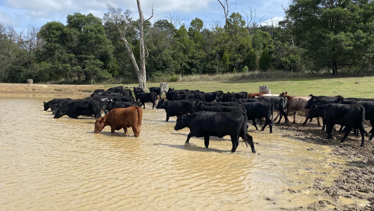
Sheep farmer Claye Peters from Cleve on the Eyre Peninsula posted footage of a full dam on his property to Twitter on Wednesday.
Well that was one eventful weekend, pretty happy that now all the dams are full across the properties pic.twitter.com/MTW5YxEAe9
— Claye Peters (@ClayePeters) January 25, 2022
Tuesday January 25
More rain is expected across the eastern states at the end of this week.
According to the Bureau of Meterology’s eight-day forecast, anywhere from 10-150mm of rain is expected across the eastern states.
And while no farmers are complaining, as they’d prefer wet than drought, wet weather in some areas is causing havoc with harvest, shearing and getting stock out of paddocks.
The forecast for more rain this week is also a positive for livestock markets, with producers confident to continue their cattle herd rebuild in the north.
Most of NSW is forecast to receive 10-50mm of rain in the coming week, Victoria is expecting 25-50mm across all areas, while eastern parts of South Australia is forecast to receive 10-50mm and Queensland ranges from 5mm up to 150mm in the far north.
Just over three weeks into the new year, Leigh Creek in outback South Australia has already received more than 55 per cent of the rain it would normally expect in a 12-month period.
Driving down the road past our house pic.twitter.com/cTbFz9kHOE
— Scott Michael (@ScottMichael83) January 24, 2022
Lake Cargelligo in NSW has recorded 194mm for the year — or 46 per cent of its annual average followed by Griffith (141mm or 36 per cent), Albury (214mm or 35 per cent), Narrandera (151mm or 35 per cent). In Western Australia, Kununurra has recorded 280mm for the month so far, followed by Halls Creek with 167mm and Fitzroy Crossing with 157mm.
AgForce Queensland cattle board president Will Wilson said the season across Queensland is “pretty positive” with a bit of a dry patch in the middle of the state.
“The thing people have now is optimism and everyone is optimistic to restock. It is amazing how quickly we can forget seasons,” Mr Wilson said.
Mr Wilson said there was some hot weather which was putting pressure on some areas, but “rain can’t be ordered”.
“In the next 10 days there isn’t too much rain expected, so the season could flatten out and we could have a good season rather than a super wet season. Rain in moderation would be good.”
Sheep farmer, Greg Rogers, from Yarto at Booligal, NSW, said while they haven’t had any significant rain since November — even though 130km away at Hay they have had more than 60mm since the start of the year — they were having a good season and everyone in the district was positive.
“It is starting to dry off now, but we had a green Christmas and it’s not often we get a green Christmas.”
Mr Rogers said they are expecting rain at the end of this week and the wind was “from the east so it might happen”.
Victorian Farmers Federation livestock group president Steve Harrison from Giffard West said they had, had about 30mm in the area in the past few weeks.
“It’s been difficult weather for those trying to harvest and for hay production. These wet summer conditions typically make the worm issue in sheep hard,” he said.
Mr Harrison said with delays due to weather, and labour shortages, some shearing teams were about a month behind.
Meanwhile, the best falls in the Northern Territory have been at Darwin (249mm), Victoria River Downs (112mm), Elliott (110mm) with Weipa leading the charge in Queensland with 258mm, ahead of Cairns (242mm), Bundaberg (172mm), Miles (110mm) and Burketown (109mm).
The best falls of the year so far in Victoria have been at Omeo (178mm), Gelantipy (116mm), Gabo Island (103mm), Bairnsdale and Benalla (92mm) and Rutherglen (85mm).
GrainProducers South Australia chief executive Brad Perry shared this photo on Twitter of damage from too much rain.
Receiving reports from growers of significant damage to farms and infrastructure on the EP. Some areas have had up to 280mm. The @GrainProducerSA team will continue to gather information on the impacts. Photo: @PetaWillmott@BrookeNeindorf@ABCNorthWest@SA_PIRSApic.twitter.com/8eyy4EsYgo
— Brad Perry (@BPerry0410) January 23, 2022
“GPSA is seeking feedback from grain growers on the damage from rain and flooding so we can get this information into government.”
“Growers in areas of the Eyre Peninsula and Yorke Peninsula are reporting significant damage with movement of topsoil impacting fences and roads,” Mr Perry said.
He said some areas had up to 320mm in a short period and “they haven’t been able to even see what impact that has had on grain still in bags on their property”.
‘Severe deficiency’ of rain takes hold in Victoria
Close to half of Victoria is experiencing severe rainfall deficiency, according to a new Bureau of Meteorology prognosis.
Read more
‘Not going to handle it’: Drought concerns grow
Dry, windy weather continues to hammer Western Victoria with farmers warning the mood is fragile amongst their community.
Read more