
January rains reduce areas officially in drought
A RED bite taken from the south western corner of Victoria reveals rain starved areas of the state.
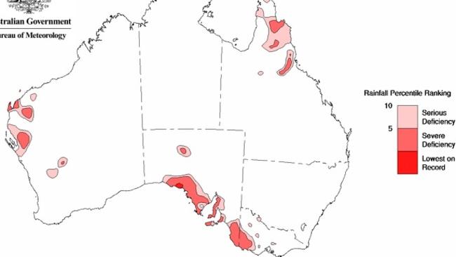
A RED bite taken from the south western corner of Victoria shows the latest rain starved areas of the state.
The Bureau of Meteorology’s latest drought statement shows January’s big rains have taken most of the southern Mallee and Wimmera “out” of the official drought map.
The latest map records seven-month deficiencies in rainfall.
Monthly rainfall was above to very-much above average (highest 10 per cent of records) in a broad band extending from the Kimberley in Western Australia, through the Northern Territory and covering most of south-eastern Australia, as well as smaller parts of eastern and western Queensland.
The bureau said the rainfall “has moderated deficiencies” in north-western Victoria and adjacent areas and, to a lesser degree, moderated deficiencies in central northern and inland Queensland as well.
Rainfall across most of south-eastern Australia, but excluding West and South Gippsland and central southern Victoria, was more than one and a half times the long-term January average. Totals were more than three times the January average in areas of the eastern half of South Australia and parts of adjacent western New South Wales.
“It should be noted, however, that January and February are climatologically the driest months throughout much of this region, and the unseasonable January rainfall was not high enough to clear rainfall deficiencies between western Victoria and the central West Coast district of South Australia,” the bureau said.
Fonterra steps up farmgate figure for New Zealand suppliers
New Zealand suppliers of Fonterra have received some welcome news from the Auckland-based processor — but it’s still the farmgate status quo for Australian farmers.

Top tales of survival in the bush
The miraculous discovery of missing man Robert Weber is just the latest tale of survival in the bush in Australia. These are some of the most famous and heartwarming from our history.