
Heaviest rainfall in 30 years forecast for Adelaide and South Australia by Bureau of Meteorology
UPDATE: HEAVY rain is falling in the north of South Australia and gradually heading south to more populated areas.
UPDATE: HEAVY rain is falling in the north of South Australia and gradually heading south to more populated areas.
While tired Country Fire Service and State Emergency Service crews start to recover from the week-long Sampson Flat bushfire that has ravaged the Adelaide Hills, they prepare to cope with the heaviest rainfall event in the state since January, 1984.
At midday on Friday, the Bureau of Meteorology said heavy falls of up to 120mm had already occurred in the north of the state.
BOM SA regional director John Nairn said up to 150mm of rain would fall across parts of SA between now and Sunday, with localised higher falls of up to 200mm possible.
He said the Pastoral districts and some of the Flinders Ranges would be the worst hit.
The rainfall at times is forecast to be torrential, creating a serious risk of flooding.
Mr Nairn said flooding could occur in the Pastoral, Flinders, Mid North, Riverland, Murraylands and Upper South East districts.
The rain could also lead to significant stream rises and possible flooding in the Mount Lofty Ranges, with Adelaide expecting 25-50mm of rain over the next three days.
“In summer, there is a warmer atmosphere, which is when we tend to see heavy rainfall events,” he said.
“January 1984 is the last time we saw an event of this nature.”
A tropical low over the northwest of the state combined with an upper trough developing over western parts of South Australia are causing the rain band.
It will develop over northern parts of the state on Friday, then extend over the ranges and eastern districts on Saturday and Sunday.
More than 7mm of rain fell across most of Adelaide to 9am this morning, with the northern suburbs feeling the brunt of the thunderstorm.
The Bureau reported that 20mm of rain fell at Buckland Park to 9am, while 18mm hit Roseworthy and 45mm was recorded at Two Wells.
Many parts of the Adelaide Hills, including the area northeast of Adelaide where just days ago an out-of-control bushfire was raging, received up to 30mm of rain to 9am, including 14mm in Gumeracha, 27mm in Birdwood and 11mm in Woodside.
Across the state, the Lower Lakes and parts of the western agricultural district received the most rainfall.
There was 37mm of rain recorded in Milang, 44mm in Callington and 20mm in Cummins.
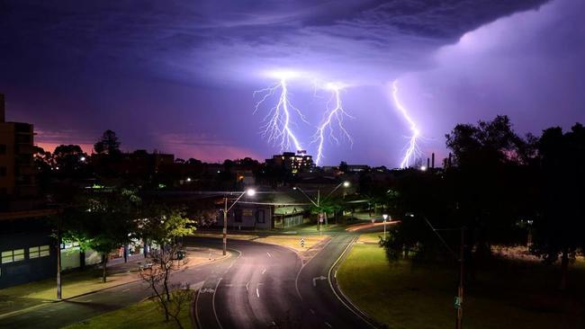
Since midday yesterday, there have been 123,000 lightning strikes.
State Emergency Service deputy chief officer Dermot Barry said there was a risk to travellers and campers across the state.
“We encourage people not to drive through flood waters and monitor the weather forecasts,” he said.
The SES has responded to more than 100 call-outs since 2pm on Wednesday.
Meantime, more than 6000 homes remain without power, as wind and rain continue to ravage the state.
On Thursday afternoon, SA Power Networks reported around 6500 homes were currently without power because of storm damage.
The largest outage is affecting more than 1300 homes in Aldinga Beach, Sellicks Beach and Sellicks Hill.
Work will continue this afternoon to restore power to these homes, but SA Power Networks has warned that this could take a while.
“Apart from one safety-related job, planned work has been cancelled and we are mobilising additional crews to worst-affected areas,” the company announced on its Facebook page.
“However, given the number and spread of outages and ongoing thunderstorm activity, customers please be prepared for extended outages.”
Late last night, more than 14,000 homes were without power.
Click here for outage details.
Gorge Road will remain closed for several days due to the risk of falling trees and rock slides in the area https://t.co/yDifSx69B1
— SA Police News (@SAPoliceNews) January 7, 2015
SA Police have advised that Gorge Rd will remain closed for several days to due to the risk of falling trees and rock slides in the area.
The maximum temperature in Adelaide reached 42.2C just after 2.30pm on Wednesday — more than 4C warmer than the Bureau of Meteorology’s initial forecast.
But the temperature dropped down to the high 30s an hour later.
Patchy rain — typical of thunderstorm activity — was seen across the Hills, northern suburbs and south towards Victor Harbor late yesterday.
Heavy downpours started falling on parts of the fireground, including Humbug Scrub and One Tree Hill, about 2.30pm.

Fonterra steps up farmgate figure for New Zealand suppliers
New Zealand suppliers of Fonterra have received some welcome news from the Auckland-based processor — but it’s still the farmgate status quo for Australian farmers.

Top tales of survival in the bush
The miraculous discovery of missing man Robert Weber is just the latest tale of survival in the bush in Australia. These are some of the most famous and heartwarming from our history.