
Bureau of Meteorology drought map has Victoria in the red
THE weather bureau has painted a large chunk of western and central Victoria in a red “danger” colour.
THE Bureau of Meteorology has painted a large chunk of western and central Victoria in a red “danger” colour.
The red denotes the parts of the state that have suffered the their lowest rainfall on record over the past years.
A weather bureau spokesman said the numbers showed many Victorian locations “had suffered their worst one-year drought in history”.
This record “rainfall deficiency” now spans three years in most of these areas. Almost half the state is either having a “serious” or “severe” lack of rain.
While many people still hesitate to call it drought, the fire engine red is most apt — these are dangerous times with farmers and their communities living rain to rain.
With an official El Niño warning in place, everyone has their eyes on spring which, like last year, will make or break the season.
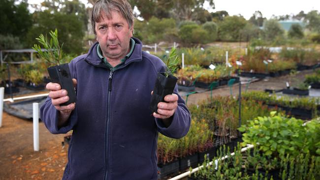
“There’s been absolutely nothing from last winter to this winter,” Dimboola nurseryman Vern Hallam, from the Wimmera Native Nursery, said.
After emptying 5mm from his rain gauge after the weekend’s disappointing offering, Mr Hallam said it was the driest 12 months he had seen.
After last spring’s lack of rain wiped out the season’s grain hopes, the Wimmera’s wheat farmers hope they can squeeze one big downpour out of the rains gods in September before the feared El Niño’s dry weather patterns arrive.
Horsham’s rain since July last year has been 240mm, down from the average of 372mm. Kaniva’s measly 268mm total for the past financial year is well shy of the 442mm average, while Warracknabeal’s 260mm for the past year compares with an average of 395mm.
“It’s surprising the crops are doing as well as they are given they’ve hardly had any rain,” Nhill wheat farmer Geoff Bone said.
“There is no moisture in the seed bed. We’ve never had that one big rain to put some juice into the soil.”
Mr Bone said the weekend’s falls ranged widely between his own 4.5mm and 20mm recorded on some farms in the area.
“The totals varied so widely and that’s just what we have been seeing over the past years. There’s not been the general rains like we used to have.”
READ MORE: Good rainfall welcome, but grain farmers need more
The bureau’s red zone extends all the way south alongside the Grampians to the sea.
Across into central Victoria, the area is also ringed in red.
Some farmers in the Wedderburn and Inglewood areas have been carting water for three years.
Victorian Farmers Federation Wedderburn branch president Graham Nesbit said it was the worst drought in living memory.
“When it doesn’t rain you call it drought,” Mr Nesbit said.
Central Victoria recorded good falls of more than 25mm in some areas, to average between 15-20mm.
One good spring rain may save the season for farmers, but much more rain is needed to fill dams, build fodder reserves and boost soil moisture.
The record dry also has the Wimmera and Mallee on an anxious footing.
Grampians water storages are now 28.35 per cent full against 37.21 per cent the same time last year and the Grampians Wimmera Mallee storages are the lowest since the end of the Millennium drought.
Fonterra steps up farmgate figure for New Zealand suppliers
New Zealand suppliers of Fonterra have received some welcome news from the Auckland-based processor — but it’s still the farmgate status quo for Australian farmers.

Top tales of survival in the bush
The miraculous discovery of missing man Robert Weber is just the latest tale of survival in the bush in Australia. These are some of the most famous and heartwarming from our history.