
Amazing pictures emerge of destructive river tornado
UPDATE: MILDURA’S devastating weekend storm may not have been a tornado after all.
UPDATE: MILDURA’S devastating weekend storm may not have been a tornado after all.
Experts at the Bureau of Meteorology have examined photographs supplied by Weekly Times of the storm at Gol Gol, near Mildura, on Saturday evening.
The experts also wound back the clock on the radar to examine the storm’s passing.
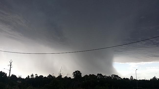
Local resident Steven Forbes-Wilson took a series of photographs with his mobile phone, showing what he believed was a tornado forming and passing close to his home in Gol Gol.
Gol Gol is a small community on the NSW side of the Murray River, adjacent to Mildura.
Millions of dollars of damage was done to the district, which includes a rich irrigation area, on Saturday about 5pm.
Victoria’s severe weather manager, Steven McGibbony, said on radar the thunderstorm showed the classic hallmarks of what is known as a “supercell”.
“These types of storms certainly have the potential to generate a tornado,” Mr McGibbony said.
“It’s clear from the damage that the storm generated some extremely strong winds, but without eyewitness reports of a funnel cloud it’s hard for us to confirm whether or not this particular storm did, in fact, generate a tornado.
“The impressive photos appear to show the storm’s main downdraft region, where colder air and heavy rain is falling out of the thunderstorm.
“For information, tornadoes do not occur in the downdraft region of a thunderstorm.”
Mr Forbes-Wilson said there was “definitely rotation in the system and there was an updraft, wind rushing towards the cloud”.
Mr Forbes-Wilson sheltered inside as the storm cell passed nearby, dumping marble-size hail on his property.
“Wind direction in the clouds above me at the time of taking the images was directly towards me from the system (westerly), initial surface wind direction was directly towards the system (easterly).
“This rotated to westerly as the system went overhead, with severe hail hitting one side of the house and then the other as the system went overhead.
“This indicated that the winds were rotating about the centre of the system which was slightly to the north of us.
“I observed the system on the Doppler radar and estimate its position in the images as being from 10km initially, down to two kilometres or so, before I stopped taking pictures.
“We were about one or two kilometres from the tornado. We were lucky I guess.”
Many people have also commented on how the storm appeared to closely follow the Murray River.
READ MORE: ‘Tornado’ hits farms at Gol Gol
Fonterra steps up farmgate figure for New Zealand suppliers
New Zealand suppliers of Fonterra have received some welcome news from the Auckland-based processor — but it’s still the farmgate status quo for Australian farmers.

Top tales of survival in the bush
The miraculous discovery of missing man Robert Weber is just the latest tale of survival in the bush in Australia. These are some of the most famous and heartwarming from our history.