
Cyclone Warning declared for region south of Dundee to WA border
The Top End won’t be hit by a tropical cyclone but authorities say torrential rain still poses a risk to lives. MORE INFORMATION AND ADVICE
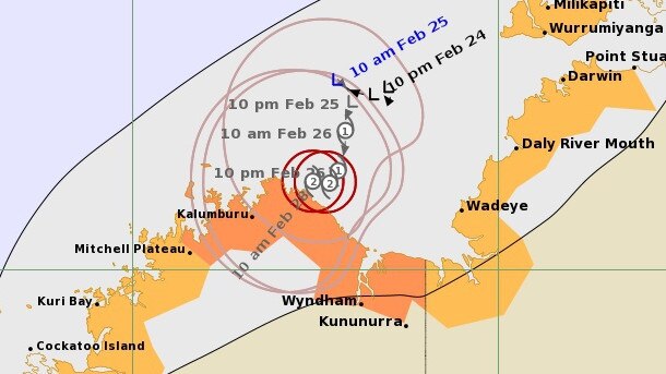
UPDATE SATURDAY 1PM: CYCLONE Anika will make landfall in Western Australia and won’t pose a risk to the Top End, despite earlier fears it could track toward Darwin.
But an active monsoon is still impacting the Top End, with concerns of torrential rain creating hazards on the road and posing a flood hazard.
Cyclone Anika will intensify to a category two storm tomorrow morning before making landfall north of Wyndham on the WA coastline.
A cyclone watch covering Darwin has been cancelled, but a warning remains in place for the western Top End between WA and Dundee beach.
Despite the cancellation, the Bureau of Meteorology on Saturday warned monsoonal showers would continue across the Top End.
NT Police northern command operations manager Mark Cunnington warned Territorians to drive safely and keep headlights on.
“Remain prepared, observe weather conditions and if necessary move inside if continues deteriorate,” Mr Cunnington said.
The wet conditions in the Top End are being driven by a La Nina, which has also created a flood emergency in southeast Queensland.
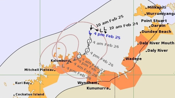
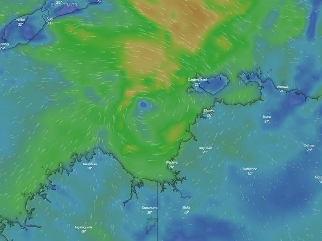
UPDATE SATURDAY 6AM: CYCLONE warnings remain in place for the region south of Dundee River towards Western Australia, with Tropical Cyclone Anika officially developing in the early hours of Saturday.
The Bureau of Meterology’s revised trackmap shows the movement of the front heading south, expected to make landfall on the coast near Kalumbura later tonight as a category two system.
Areas of the Top End remain on cyclone watch.
Wind gusts of up to 100km/h are expected around Kalumburu this morning, and could be seen around the NT border if the cyclone path changes.
People in or near Wydham and Kalumburu are on blue alert and urged to prepare of cyclonic weather.
The BoM have classed the cyclone as “slow moving”, with the possibility of the cyclone developing near the NT coast becoming less likely.
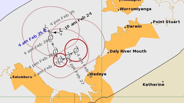
UPDATE FRIDAY 5PM: COMMUNITIES between Dundee River and Western Australia are bracing for gale force winds and torrential rain as a potential tropical cyclone bears down on the Top End.
Despite a revised track map on Friday afternoon showing the storm making landfall in WA, concerns remain about the potential for torrential rain and flash flooding in parts of the Northern Territory.
And the Bureau of Meteorology hasn’t yet ruled out the risk of the erratic storm heading toward Darwin.
Residents in Greater Darwin are being urged to brace for a monsoonal deluge, with rainfall totals of up to 150mm possible in parts of the Top End over the weekend.
Despite the Bureau of Meteorology saying the cyclone will most likely track toward the WA coast, the unpredictable system could still track east toward Darwin.
The tropical low over the Timor Sea is expected to intensify into a cyclone sometime on Saturday and potentially reach category 2 strength. A cyclone warning zone for gale force winds within 24 hours has been declared between Dundee Beach, south of Darwin, and Mitchell Plateau in WA.
Wadeye and Daly River are among communities within the warning zone.
A further watch zone extends over the entire of the Tiwi Islands, and from Dundee Beach across Darwin to Point Stuart.
NT Police northern command operations manager Mark Cunnington warned Territorians to take care on the roads and around flooded storm drains amid the deluge.
“Residents within the warning area, particularly around Wadeye, should finalise their preparations and be prepared to take shelter, should the weather start to deteriorate,” Mr Cunnington said.

“All other areas, just monitor the situation, watch out for information being released throughout today.”
Mr Cunnington said heavy rainfall was still anticipated around Darwin and Palmerston, with residents urged to keep themselves and their children away from flooded storm drains.
Bureau of Meteorology NT manager Shenagh Gamble said the tropical low was located “in very favourable conditions” and the storm’s path remained very unpredictable.
“Darwin remains within the watch area which means it is still incredibly possible that the system could move further east and impact Darwin sometime over the weekend,” Ms Gamble said.
Secure NT and BOM will provide updates on Saturday.
UPDATE FRIDAY 1pm: A Cyclone Warning has been declared for the region south of Dundee to the WA border.
The current tropical low is currently located in the Timor Sea about 330km west of Darwin and is expected to develop into a tropical cyclone later on Friday or early on Saturday.
As a result a cyclone warning has been declared for the Northern Territory from south of Dundee through to the WA border.
A cyclone watch remains in place for the NT from Point Stuart around to the WA border including the Tiwi Islands and Darwin.
Bureau NT manager Shenagh Gamble said it was still a possibility for the system to change direction.
“While the current track takes the system further toward the Kimberly coast there remains the possibility that the system could move to the east,” Ms Gamble said.
“The large watch area reflects the uncertainty aroun dthe possible tracks that this system could take.”
A flood watch also continues for the Northern Territory’s northwest coast.
UPDATE FRIDAY 10.30am:
AREAS of the NT remain on cyclone watch, with a tropical cyclone expected to develop tonight and move closer to the coast over the weekend.
Parts of the Top End remain on watch, from Point Stuart to Dundee Beach, including the Tiwi Islands, Wadeye and Darwin in the affected zone.
A warning has also been issued for Mitchell Plateau to the WA/NT border.
An updated track map shows the front has moved, with a statement from the BOM saying there is “uncertainty about the movement” of the current tropical low.
“There remains the possibly of a track moving to the east over the Top End though the track to the west southwest towards Western Australia is becoming more likely,” the update said.
Minister for Police, Fire and Emergency Services Nicole Manison encouraged Territorians to keep an eye on Secure NT for the latest advice.
“Make sure you have a think about your own personal situation right now. Make sure that your yard is clean, that you’ve got supplies in case we do get a cyclone,” she said.
“Don’t underestimate the dangers of what a cyclone might bring.”
The NTFL final series this weekend will be suspended if a cyclone warning is issued.
UPDATE FRI 7.45am: TOP end residents are being urged to have their emergency cyclone kits prepared as authorities warn of severe weather on the way, with a potential Category 2 cyclone forming off Darwin’s coast.
A slow moving tropical low remains over the Timor Sea and has the potential to develop into a cyclone on Friday or Saturday.
The Bureau of Meteorology’s latest track map forecasts the weather system moving towards Darwin in a northwesterly direction.
NT Emergency Service Commissioner Mark Cunnington said there were several things people should include in their emergency cyclone kits.
“People should be checking and making sure that their emergency kit at home is prepared and ready to go with any food items, extra water, battery operated radio and torches, any medicinal and baby needs,” he told ABC Radio on Friday morning.
“Make sure you have those important papers stored away out of any danger areas.
“Know where you’re going to shelter, whether that’s going to be at home with family or friends or in perhaps one of the public shelters within the community.”
Mr Cunnington also encouraged Top End residents to tune into the emergency broadcaster and follow Secure NT for updates.
The watch zone is in place from Point Stuart to Kalumburu, including the Tiwi Islands, Darwin, Wadeye and Wyndham.
Mr Cunnington said if people have pets they should make plans for them as well.
“The best thing you can do with pets is make sure that you have a pet emergency kit, make sure that your pets are registered, keep a list of any emergency phone numbers including your vet, the RSPCA and local council in case for whatever reason your dog might get away during an event,” he said.
“Know where you might take your pet – if you’re going to shelter them away from your home as well or if you’re going to move and not take them with you, then have a good idea of where that’s going to be.”
As wet weather wreaks havoc in the Top End, NT Police have called on motorists to drive to the conditions and switch their lights on.

It follows four minor motor vehicle accidents in the Darwin area in the 24 hours to Friday morning.
Delaneys Country and Western store owner Dwyn Delaney said he had put in place an action plan to get through a cyclone if it came.
“I went through Cyclone Tracy and I reckon I’m an expert now,” Mr Delaney said. “I get a couple of cartons and a leg of ham and sit tight.”
He said he would tape up the windows of his CBD store as a precaution.
BoM upgrades cyclone warning risk
THURSDAY, 6PM
THE chance of a cyclone forming off the coast of Darwin is growing by the hour, with the Bureau of Meteorology upgrading the risk on Saturday and Sunday to high.
The risk of a cyclone on Saturday had previously been deemed ‘moderate’, however an update to the Bureau’s website has upgraded the warning.
There is now a moderate chance of it developing on Friday.
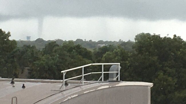
The threat of a cyclone wasn’t the only wild weather in the Top End on Thursday, with the Bureau of Meteorology tweeting an image of a waterspout off East Point and Nightcliff.
The tropical low in the Timor Sea northwest of Darwin is expected to intensity into a category two cyclone by Sunday morning and track to the southeast.
Darwin, the Tiwi Islands and Wadeye are inside a cyclone watch zone stretching from Point Stuart to Kalumburu on the West Australian coast.
The current tropical low is slow moving and is expected to bring heavy rain and squally winds to the Territory coastline from Thursday.

A flood watch has also been issued for coastal catchments from the South Alligator River to the Moyle River including the Tiwi Islands.
Bureau of Meteorology NT manager Shenagh Gamble said the exact path of the system remained uncertain.
“The future movement and development of this low is uncertain and several scenarios are possible,” Ms Gamble.
“Gales with gusts of up to 100km/h may develop on the Tiwi Islands early on Saturday morning. Extending further south to the mainland NT later that day.
“We encourage people to stay up to date with warnings on the Bureau website and our app.”
Ms Gamble said the strength of the system could be determined by how long it stayed over water, with a slow moving storm expected to be more dangerous.
Updates will be issued by BOM through Friday.
Warm surface water temperatures are creating conditions favourable for the formation of a cyclone.

Northern Command operations Manager Mark Cunnington advised Territorians to prepare for dangerous floodwaters and winds.
“It’s prudent for people in those areas to prepare now for a cyclone,” Mr Cunnington said.
“Prepare your emergency kit at home, have food, water, emergency stocks of any medicines and baby needs on standby.
“With heavy weather around street rises will be quite strong, never drive into crossings or flooded roads.”
If the tropical low does form into a Cyclone it will be known as Vernon.
Mr Cunnington advised residents on the Tiwi Islands to prepare to either shelter in place or leave early via plane or ferry.
Delaney’s Country Western store owner Dwyn Delaney said he had put in place an action plan to get through a cyclone if it came his way.
“I went through Cyclone Tracy and I reckon I’m an expert now,” Mr Delaney said.
“I get a couple of cartons and a leg of ham and sit tight.”
Mr Delaney said he would tape up the windows of his CBD store as a precaution.
Top End put on Cyclone Watch
THE Top End has been put on Cyclone Watch heading into the weekend.
A monsoonal trough over Territory waters has been predicted to have a moderate likelihood of developing into a tropical cyclone on Saturday.
The watch area extends from Point Stuart to Kalumburu in Western Australia with that area including Darwin and the Tiwi Islands.
The current tropical low is slow moving in the Timor Sea and is expected to bring heavy rain and squally winds to the Territory coastline from Thursday.
A flood watch has also been issued for coastal catchments from the South Alligator River to the Moyle River including the Tiwi Islands.
Bureau NT manager Shenagh Gamble said the exact path of the system remained uncertain.
“The future movement and development of this low is uncertain and several scenarios are possible,” Ms Gamble.
“Gales with gusts of up to 100km/h may develop on the Tiwi Islands early on Saturday morning. Extending further south to the mainland NT later that day.
“We encourage people to stay up to date with warnings on the Bureau website and our app.”
Northern Command operations Manager Mark Cunnington advised Territorians to ensure they’re prepared for dangerous floodwaters and winds.
“It’s prudent for people in those areas to prepare now for a cyclone,” Mr Cunnington said.
“Prepare your emergency kit at home, have food, water, emergency stocks of any medicines and baby needs on standby.
“With heavy weather around street rises will be quite strong, never drive into crossings or flooded roads.”
If the tropical low does form into a Cyclone it will be known as Vernon.
EARLIER: A POTENTIAL cyclone is forming on Territory waters with a moderate likelihood of a trough and two tropical lows turning into a cyclone by Saturday.
According to the Bureau of Meteorology (BoM), the trough sitting over Northern Australia waters is expected to become more active and one or two tropical lows may form within the trough on Thursday.
The environment is generally favourable for development and the risk of this system developing into a tropical cyclone in the Northern Region increases to Low on Friday and Moderate on Saturday.
There is high uncertainty in the track this system will take.
More information will be released after a cyclone press conference later in the day on Thursday.
More Coverage


Originally published as Cyclone Warning declared for region south of Dundee to WA border

WPL WRAP: Premiers toppled as Tigers deliver 100-gamer a win
It was another exciting round of WPL action with a litany of post season defining results playing out across the competition. Read our Round 16 wrap here.
Read more

Local orgs leading climate change solutions
Two Northern Territory initiatives have won a share of $685,242 for their work leading local climate change solutions. See the projects.
Read more