This was published 7 months ago
How climate change accelerated spring winds
By Caitlin Fitzsimmons
Strong winds in eastern Australia this week are being driven by climate change interfering with jet streams, the powerful high-altitude winds that encircle the globe.
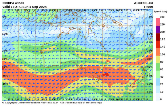
Australia’s two jet streams – subtropical and polar – have combined over the continent’s south-east. This has caused strong winds on the surface of the earth that have brought a cold front to Victoria and southern NSW, and flipped between hot desert air and cool winds over Sydney and further north.
Wild winds have battered Victoria and NSW, fuelling bushfires and felling trees and powerlines, but the strong winds may have also generated a record amount of wind energy. This comes as official figures released on Monday show last month was Australia’s hottest August on record.
Dr Milton Speer, a visiting fellow in the School of Mathematical and Physical Sciences at the University of Technology Sydney, said: “The jet streams are the main thing affecting the weather in south-eastern Australia at the moment.”
The jet streams blow from west to east, driven by the earth’s rotation. They are at their strongest about 10 kilometres above the surface, usually about 200km/h stretching across a horizontal area of 100-200km. They are used by intercontinental jetliners travelling eastward to save on fuel. The less intense, yet strong, surface winds caused by the polar jet stream have been known as the Roaring Forties by sailors for centuries.
Speer said Bureau of Meteorology data showed the polar jet stream moving at 200-280km/h as of 4am on Monday, and stretching horizontally across several hundred kilometres to affect a large swath of the southern part of the continent. The subtropical jet stretched 150-200 kilometres with weaker speeds and was almost merged with the polar jet on the NSW Mid North Coast.

The jetstreams with a scale showing wind speeds as of 4am on Monday.
Speer said the subtropical and polar jet streams were usually split during the cooler months from about April to October. While they came together in summer, they usually sat over the Southern Ocean below the continent, he said.
Speer said the latest research suggested that the extent of sea ice melting in Antarctica this winter had pushed the polar jet further north, while the marine heatwave in the tropics had pushed the subtropical jet further south. The result was that the two had combined over south-eastern Australia, amplifying the effect.

Emergency crews work on a tree downed by strong winds in Victoria.Credit: Victorian State Emergency Service
A 2023 study in Nature Climate Change found the fastest upper-level jet stream winds will accelerate by about 2 per cent for every degree the world warms. Speer said this was already causing more turbulence on flights.
Dr Martin Jucker, an atmospheric dynamics and climatology expert at the University of NSW, said the polar jet affected surface winds more than the subtropical jet.
While there are jet streams over central and Western Australia, Jucker said the polar jet was only over the south-east, the region where the jets interact most.
Jucker said climate change was making the jet streams move further south on average, and this could result in prolonged periods during which they sat below the continent and any heatwaves or dry spells in Australia would last longer. But climate change could also mean jet streams move around more often.
“It’s almost like a water hose in your garden. If you don’t hold the end and you increase the water pressure, what will it do?” Jucker said.
“It will just wiggle around like crazy, right? The flow in the water hose is going to be stronger – that’s your stronger jet stream, but it will also wiggle around much more, and that’s the variability I was talking about.”
Windlab wind engineer David Osmond said Victoria’s wind generation has been setting records, generating twice normal levels in recent days. In a post on X, he said it was rare for wind turbines to shut down due to high winds.
While many weather stations have recorded gusts of more than 100km/h, the sustained 10-minute average was usually below 72 to 90km/h, the threshold for shutting down turbines.
National climate figures from the Bureau of Meteorology show winter 2024 was the second warmest on record (since 1910) for Australia and the hottest for Western Australia. This was based on the national mean temperature being 1.48 degrees above the 1961 to 1990 average.
The national average maximum temperature for winter was 1.66 degrees above the long-term trend, and the national average minimum temperature was 1.3 degrees higher than usual.
The winter heat was largely driven by the warmest August on record nationally and for NSW, Victoria, Tasmania, Queensland and South Australia, and the second-warmest for Western Australia and the Northern Territory.
The national mean temperature was at 3.03 degrees warmer than the 1961-1990 average, the average maximum was 3.50 degrees and the average minimum was 2.56 degrees, all the warmest on record.
August 2024 was hot compared with more recent climate trends as well. Weatherzone’s Ben Domensino said the mean temperature was 2.43 degrees above the 1990-2020 average.
Australia’s hottest August day on record was August 26, when it reached 41.6 degrees at Yampi Sound in WA.
Victoria had its driest winter since 2006, 30.2 per cent below the 1961-1990 average. The state’s August rainfall was 55.4 per cent below the norm.
Get to the heart of what’s happening with climate change and the environment. Sign up for our fortnightly Environment newsletter.