This was published 8 months ago
‘Astonishing intensity of heat’: Australia just recorded its hottest ever winter’s day
By Caitlin Fitzsimmons and Bianca Hall
Trees are blossoming, cafe dining has shifted outdoors, and Sydneysiders have flocked to beaches and parks as temperatures hit 30 degrees across the city on Friday.
The freakishly hot end to winter has also sent local and national climate records tumbling, sparked wildfires around NSW, and led to early closures and patchy snow at many ski resorts.
The hottest winter day ever recorded for Australia was this week: 41.6 degrees at Yampi Sound in the Kimberley region of Western Australia on August 27. London-based meteorologist Scott Duncan described this on X as an “astonishing intensity of heat for winter”.
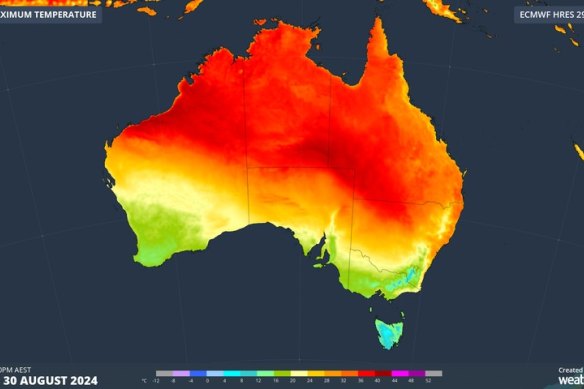
On Friday, a record-breaking hot air mass was focussed on parts of Qld, NSW, SA and the NT. Credit: Weatherzone
The Bureau of Meteorology said Sydney on Friday recorded preliminary record temperatures for August at several weather observation stations, including Observatory Hill, Sydney Airport, Bankstown and Penrith Lakes.
Ben Domensino from Weatherzone said Queensland broke its winter record on Friday with a reading of 39.6 degrees at Birdsville at 3.30pm, about 15 degrees above average for this time of year. The previous state record was 38.5 degrees at Bedourie in August 2009.
Local records also tumbled this week including Bourke in NSW, Moomba in South Australia, Alice Springs in the Northern Territory and Broome in Western Australia.
The unseasonably warm weather coupled with strong winds could be driven by the jet stream, a powerful ribbon of strong winds high in the atmosphere that are snaking rapidly across the southern hemisphere from west to east.
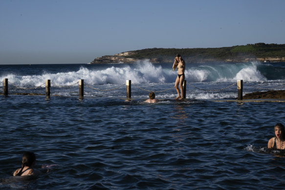
People take advantage of a warm winter’s day at Mahon Pool, in Maroubra, Sydney.Credit: Janie Barrett
Studies have found the jet stream is associated with an increased chance of heatwaves, and a 2023 study in Nature Climate Change found the fastest upper-level jet stream winds will accelerate by about 2 per cent for every degree that the world warms.
It might feel like only yesterday that we were talking about a “polar vortex” bringing freezing weather to eastern Australia. But don’t be fooled: the cold snap didn’t last long.
Bureau of Meteorology senior climatology specialist Zhi-Weng Chua said “despite some cool temperatures at times, winter has been warmer than usual across the country”.
In Sydney, Chua said figures from June 1 to August 29 show temperatures were well above average for winter, and that they are tracking to be in the top 10 per cent of data records going back to 1910. Rainfall was about average for the season.

Chloe Beeler takes advantage of a warm winter’s day in the Ross Jones Pool at Coogee.Credit: Janie Barrett
Chua said winter was tracking at about 1 degree above the 1961–1990 average for maximum temperatures, and minimum and mean temperatures were 1 to 2 degrees above average. For August so far, the maximum and mean temperatures were 2 to 3 degrees above average, and the minimum temperature was 3 to 4 degrees above average.
The bureau’s outlook for spring is for warmer than usual weather across most of NSW, while there could be more typical conditions in Sydney. Most of the state has an increased chance of above average spring rainfall, and there is an increased chance for unusually high spring rainfall in northern NSW.
Sydney temperatures this week have been in the mid to high 20s, well above the average maximum temperature of 17.9 degrees for Observatory Hill in August. The record maximum for August is 31.3 degrees.
Rural Fire Service inspector Ben Shepherd said the heat and strong winds created bad fire conditions and, during a 24-hour period on Wednesday, there were 97 bush, grass and scrub fires across NSW. This included a grass fire near Liverpool in Sydney’s south-west that threatened homes on Wednesday.
Shepherd said the outlook remained for a neutral fire season, after three years of relatively quiet fire activity.
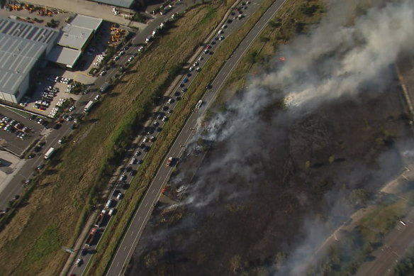
Helicopter vision of a fire along Camden Valley WayCredit: Nine News
Jo Dodds from Tathra on the NSW South Coast, president of the Bushfire Survivors for Climate Action, said her phone was running hot all week with calls and messages from friends and neighbours alarmed by the unseasonably warm weather.
“This is a reminder of what we’ve already been through and what we know is coming with increasing frequency and ferocity, being climate-generated disaster events like bushfires, but also floods and storms,” Dodds said. Tathra had severe bushfires twice in 2018 and again in 2019-20.
In the Australian Alps, it took until late July for decent snow cover, and it was patchy again by mid-August.
Sam Beaver, policy lead at climate activist group Protect Our Winters, and research officer at the Australian National University, said the past few weeks of 10-degree days, rain and strong winds had depleted the snowpack at most resorts.
At Perisher, it was only possible to ski between all four resorts for 30 days, while Smiggin Holes and Guthega will close by September 1 rather than stay open for spring skiing.
Vail Resorts vice president and general manager for Perisher Ski Resort, Nathan Butterworth, said it had been a “solid season”.
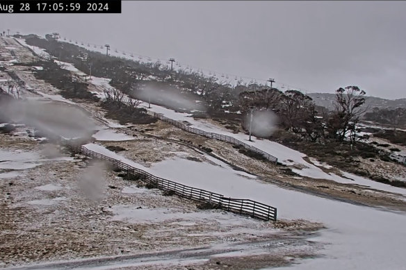
Screenshot of the snowcam showing conditions at Guthega on Wednesday August 28.
“As we move into the tail end of the season, warmer temperatures and rain have reduced operating footprints across Perisher, but that doesn’t mean there’s not still excellent spring skiing and riding,” Butterworth said.
“We’ve had some good conditions, and we’ve had some really terrible conditions, but overall, the trend is that we’re just seeing less snow, and our winters shortening,” Beaver said. “In the last few weeks, it’s deteriorated really rapidly.”
Emeritus Professor Lesley Hughes at Macquarie University, a founding councillor of the Climate Council, said the Australian winter was warm on average, with only a brief period of cold weather.
“We’ve had a short winter and a warm winter,” Hughes said. “The number of records broken this winter is an ominous warning.”
As well as the record in the Kimberley, Hughes said Roma in Queensland was 11 degrees above average for August, and Oodnadatta in South Australia was 3 degrees above average.
Weatherzone’s Ben Domensino said 2024 was on track to be Earth’s hottest year on record, beating the record set in 2023, even if a La Nina system formed and brought cooler weather later in the year.
Get to the heart of what’s happening with climate change and the environment. Sign up for our fortnightly Environment newsletter.