
Burdekin flood threat eases as BOM investigates gauge glitch
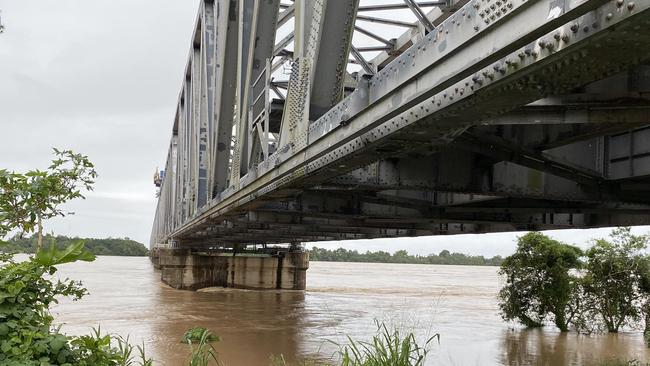
The Burdekin River is no longer expected to reach major flooding levels at Inkerman Bridge, with the Bureau of Meteorology set to investigate an issue with an automated gauge at the site.
Townsville
Don't miss out on the headlines from Townsville. Followed categories will be added to My News.
UPDATE: The Burdekin River is no longer expected to reach major flooding levels at Inkerman Bridge, with the Bureau of Meteorology (BOM) set to investigate an issue with an automated gauge at the site.
Meteorologist Shane Kennedy confirmed that despite earlier concerns, the Inkerman Bridge was unlikely to experience major flooding on Sunday.
Water levels had surged beyond moderate flooding at around 11m on Saturday night but are now expected to peak at around 11.5m — just shy of the major flood mark of 12m.
Due to problems with the automated gauge at the bridge, BOM has been relying on manual readings provided by the council to keep its flood warnings updated.
The technical issue left some residents taking matters into their own hands — literally — heading out with torches on Saturday night to check water levels themselves and share their findings on social media.
“There was an issue with the automated gauge that’ll be looked at after this event,” Mr Kennedy said.
“So we’ve been getting manual readings instead, and that’s what’s feeding into the model.”
He added that the exact cause of the fault remained unknown and would require further investigation.
Premier David Crisafulli, speaking in Brisbane on Sunday, said he understood the bridge’s automated flood gauge was a council asset.
He was aware of reports it was not working currently and had spoken with the mayor, but indicated that it would be among the many vital infrastructure assets that would be rebuilt in a resilient manner so they did not fail in the next natural disaster.
“We’re actively getting more information. If there are issues with that infrastructure (the gauge), we’ve got to improve it. It’s as simple as that,’’ he said.
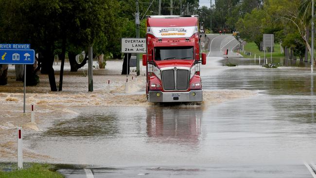
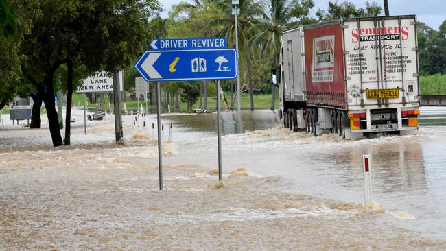
Due to moderate flooding, the Bruce Highway at Plantation Creek was closed to traffic early Sunday morning. By lunchtime, it had reopened to high-clearance heavy vehicles.
Burdekin Mayor Pierina Dalle Cort stressed that getting essential food trucks through to those in need up north was a priority.
But floodwaters aren’t the only concern. Mayor Dalle Cort also issued a stark warning about local wildlife, particularly in Groper Creek.
“There’s also been mention at Groper Creek that there’s some crocodiles in the water,” she said.
“So I dare say, the residents in Groper Creek are well aware of the fact to stay away, out of the water there.
“I’d rather not see anybody here walking through the water at Plantation Creek either because that could be an issue as well—for hygiene and also those creepy crawly things that could be in the water.”
Meanwhile, stranded travellers were left scrambling for accommodation as only trucks were allowed to cross Plantation Creek on Sunday.
Bowen man Robbie Beresford, visiting Townsville for his daughter’s 21st birthday, found himself stuck in Ayr but was touched by the town’s generosity.
Despite Park Motor Inn Motel being fully booked, the owner offered him a mattress in the laundry and a spot in the office to watch TV.
“I said, ‘Good, I can watch the cricket.’ And she said, ‘Oh no, I hate cricket,’” he recounted with a laugh.
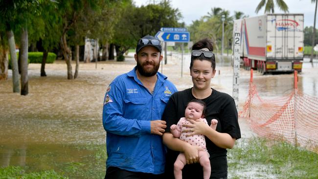
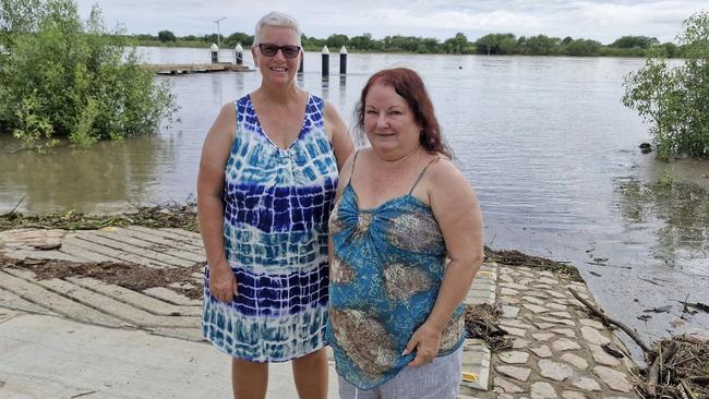
Onlookers gathered at Plantation Creek to witness trucks navigating the floodwaters, including Aaron and Shannon Benato, who brought their three-month-old baby Myla to see her first North Queensland flooding event.
Mrs Benato, a lifelong local, recalled the 2019 floods as the last major weather event she experienced.
“We’re pretty good where we are,” Mr Benato said, adding that Myla had handled the wild weather well. “It doesn’t really phase her — she’s just been cooped up inside.”
The BOM reported that, as of 9am Sunday, most parts of the Burdekin region had recorded rainfall between 20mm and 60mm over the past 24 hours.
But the rain isn’t done yet. More wet weather is expected this week, with heavier falls predicted from Tuesday onwards.
“We’re expecting daily rainfall will generally be in the 30 to 50mm range for Sunday and Monday, but there still is the potential we could see some isolated falls in the 100 to 200mm range,” Mr Kennedy said.
“Then on Tuesday, there will likely be a slight increase in rainfall — more in the 30 to 80mm range, with totals of 100 to 200mm or more becoming more likely.”
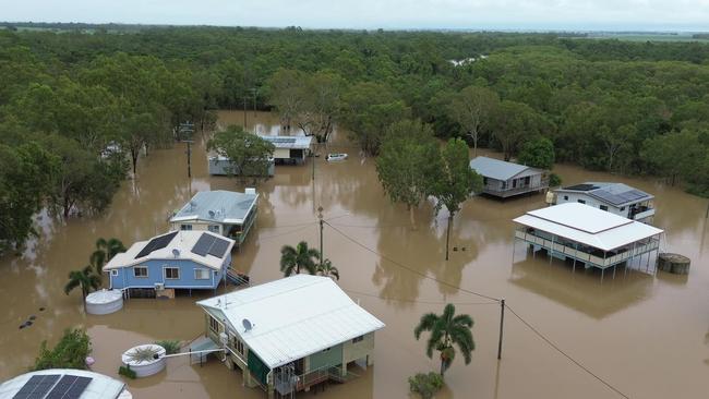
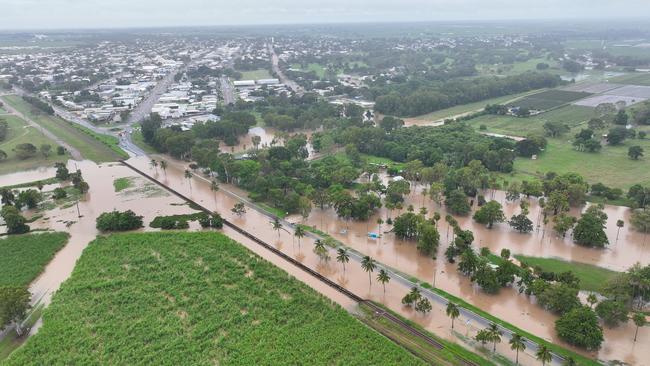
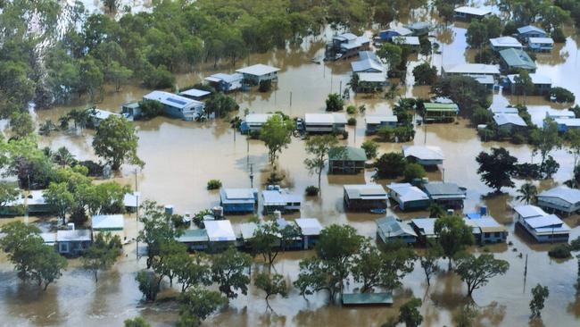
EARLIER. Saturday, February 8. Home Hill businesses and residents are preparing for potential flooding of which they haven’t seen in more than three decades, with the Burdekin River likely to reach major levels Sunday.
Floodwater covered the Bruce Highway before 2pm Saturday, only open to high-clearance vehicles and with police on site. At 6pm Saturday, Queensland Police advised the highway was closed to all traffic.
The Burdekin Falls Dam hit 200.06% at 6.45pm on Saturday. The historical high was 221.15% on February 21, 1991.
The Burdekin Shire Council advised residents to prepare now for potential major flooding of the Burdekin River at Inkerman Bridge, with the Bureau of Meteorology expecting it to reach the 12 metre major flood level Sunday afternoon.
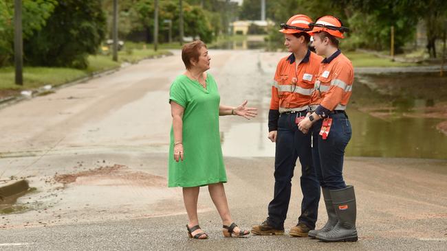
Speaking after the latest round of briefings for the Local Disaster Management Group, Burdekin Shire Mayor Pierina Dalle Cort said they were monitoring the challenging weather situation closely and preparing for the worst case scenario.
“The Bureau of Meteorology has told us that the Burdekin River at Inkerman Bridge continues to rise during this flood event,” Ms Dalle Court said.
“Targeted messaging to the Home Hill community has commenced. The Home Hill community has been very proactive in sandbagging and protecting homes and businesses, but at this stage, there is no impact to Home Hill.
“Giru is currently experiencing major flooding, and reports from Giru Queensland Police Service is that the river is steady and no issues have been reported and power still remains.”
She said they would continue to monitor the situation closely.
“I want to assure the community that we hope it won’t reach the higher (water) level. However, we are preparing for the worst case scenario,” she said.
“Drivers, do not drive through flood waters, rivers or creeks. If it’s flooded, forget it.”
She said there were plenty of emergency services resources on the ground, the hospitals were well prepared, the well-stocked supermarkets were prepared to open on Sunday, waste facilities were functional, there was no shortage of fuel, and the lines of communications were still connected.
There was plenty of sand still available at the SES depots at Ayr and Home Hill.

“If you’re able, please assist our SES crew by filling your own bags and leaving the pre-filled ones for those who need extra support,” she said.
“There is still time to ensure you and your household are prepared. Residents are urged to secure essential supplies, including food, water, medication, emergency kits, and don’t forget to make arrangements for household pets and other animals.
“Watch for the warnings on the Burdekin Disaster Dashboard and Bureau of Meteorology.”
With childhood memories of Plantation Creek “which always came over” to cut the highway, Ms Dalle Cort hoped that a portion of the government’s money being promised to upgrade the Bruce Highway, would go towards building a bridge to floodproof the troublesome stretch of road.
She applauded the work of the region’s team of SES volunteers, encouraging community-minded people to play their part by stepping up and joining the organisation.
For people seeking additional information, she said the council’s customer service centre would remain open on Saturday and Sunday from 8am to 5pm.
Groper Creek — a fishing village of about 60 residents and home to Groper Creek Caravan Park — is downstream of Inkerman Bridge, with residents already having been cut off by floodwater for more than week.
Caravan park manager Jeanette Garvey said the last time the area saw major flooding was in February 1991, when Inkerman Bridge peaked at 12.53m.
Other major floods were experienced in 1974 (12.30m), 1972 (12.04m), 1968 (12.04m) and 1958 (12.62m)
“Further rainfall and thunderstorms are forecast over the next few days. A severe weather warning is current for parts of North Tropical Coast and Tablelands and Herbert and Lower Burdekin Forecast Districts,” the Local Disaster Management Group update said.
In their 6pm update, the Bureau of Meteorology advised the Burdekin River at Inkerman Bridge (manual gauge) was at 10.90 metres at 1pm and rising, with the level likely to reach the major flood level (12.00m) Sunday afternoon. Further rises are possible with forecast rainfall.
Referencing the record of past flooding events, floodwater will move towards the Home Hill township and farms when the river level hit 11.28m at Inkerman Bridge.
Historically, at 11.58m this level impacted the lower business section of Home Hill, lower Jarvisfield and Rita Island farms.
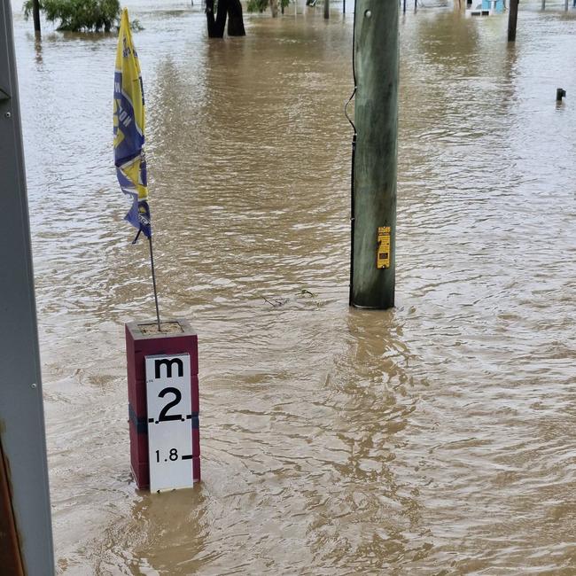
At 11.89m, at least half the cane growing area was flooded and after the major flood level was reached (12m) water came in the Home Hill business section out the outskirts of the Ayr township.
“You may become isolated until flood waters recede,” the LDMG warned.
“You may lose services like power, communications, water, sewerage and gas.”
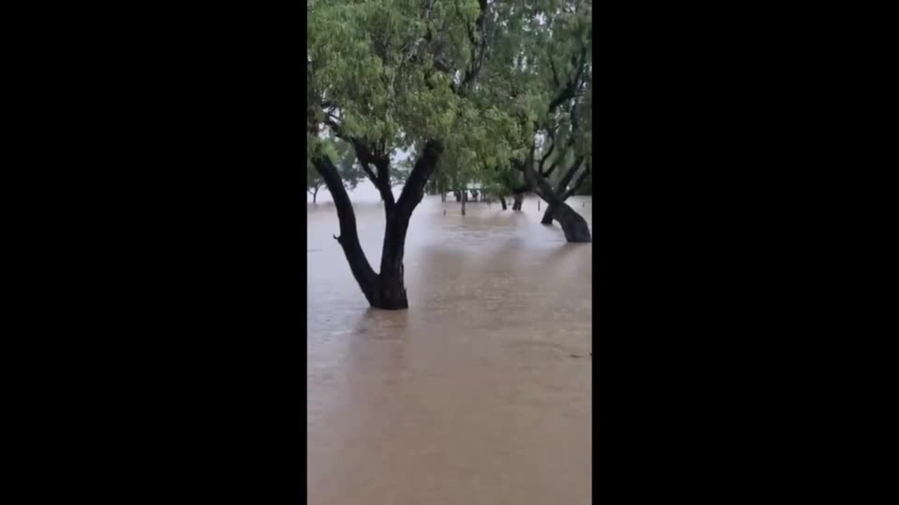
Earlier this week, with their huts built on stilts to withstand major flooding, even the long-term residents of Groper Creek were “caught by surprise” with the relentless rain and flooding lashing North Queensland.
The 60-odd residents of the small fishing village in the Burdekin, 15km from Home Hill, have been cut off since Friday night.
Groper Creek Caravan Park manager Jeanette Garvey said it had been all hands on deck as the community prepared for major flooding, likely to isolate residents for days.
“The latest advice from the Bureau is that the Burdekin River will reach 10 metres at Inkerman Bridge Wednesday morning so we’re expecting about 1.5 metres of water under huts, but it depends in the coming hours,” Mrs Garvey said.
The Bureau of Meteorology said further rises were possible with the arrival of upstream flow that comes from Charters Towers, and forecast rainfall.
In the 15 years of living at Groper Creek, the long-term Burdekin local has experienced floodwater under her hut about 10 times.
Long-term locals have weathered dozens more floods and cyclones.
“All the community down here, we’ve all been communicating with each other and those who have been here a long time and been through plenty of floods have been helping the newer residents,” Mrs Garvey said.
“It’s all about neighbours helping neighbours and we’ve secured everything in the caravan park which is always hard work.”
The unofficial Groper Creek besser block ‘flood marker’ sits outside Mrs Garvey’s house, built by her husband Danny who died in 2023, which shows how high flood waters had risen in past years.
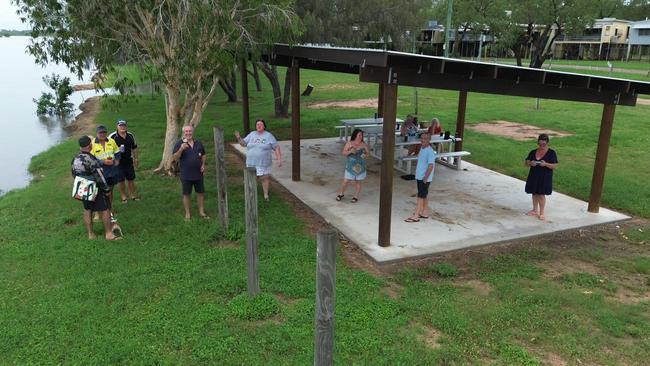
Locals gathered with a few drinks at the newly-opened public shelter built in Mr Garvey’s honour to check on the creek level on Tuesday afternoon before heading home, where they’ll likely stay for several days until waters recede.
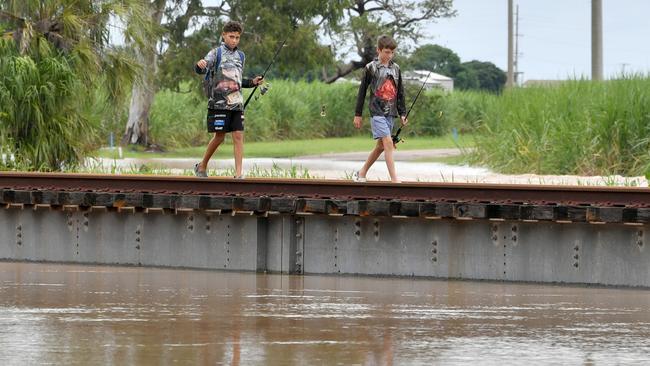
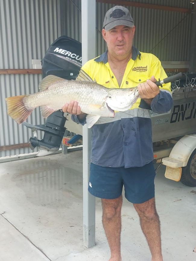
“There’s still been plenty of fishing … actually all this rain has brought out the barramundi so it’s been a great start to barra season already,” Mrs Garvey said.
The 2019 flood claimed the life of Home Hill man Justin Scott, who was swept away when a boat collided with a jetty pylon. His body has never been found.
Earlier in the day, Burdekin Shire Mayor Pierina Dalle Cort gave an update on the Burdekin flooding.
She said the Bruce Highway had reopened between Ayr and Townsville about 9am Tuesday morning, allowing supplies to restock Giru, along with the Burdekin’s two supermarkets.
The Giru township remains under essential water use restrictions until supply levels can be replenished, a process that could still take some time, with residents advised to only use water for essential needs.
More Coverage


Originally published as Burdekin flood threat eases as BOM investigates gauge glitch
Join the conversation

Man rushed to hospital with burns after large house fire
A man has been taken to hospital with burns as multiple fire crews work to battle a large house fire. DETAILS
Read more
Small family bakery a must try for matcha and focaccia
Known for their fresh bread, sandwiches and treats a North Shore cafe is quickly building a community of loyal customers. See why.
Read more