
Rainfall records smashed, Tasmania sees equal-warmest January
The Apple Isle has felt the heat with the first month of the year equalling the hottest on record, and several areas recording their highest daily rainfalls. FIGURES + FORECAST >>

Weather
Don't miss out on the headlines from Weather. Followed categories will be added to My News.
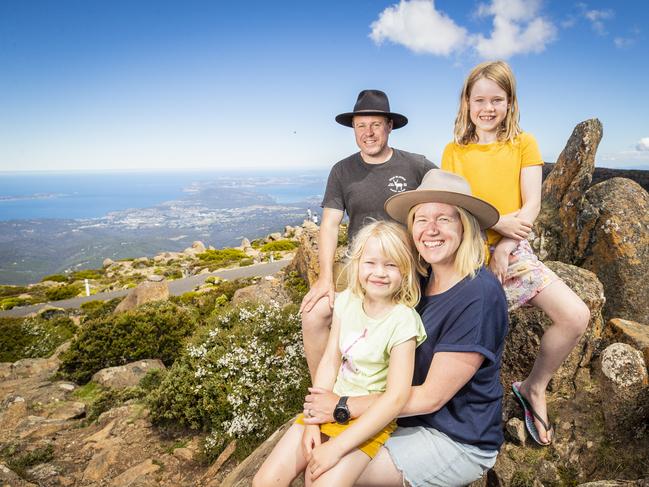
Cameron Upshall and his family have relished the views from atop kunanyi/Mt Wellington and explored the state on their Tassie leg of a truck trip around Australia.
The Victorian, his wife Reannon Upshall and their children Madison, 8, and Georgie, 7, have been blessed with stellar January weather on their journey through Hobart, Freycinet, St Helens and the West Coast.
“It’s been fantastic really, especially the last couple of weeks,” Mr Upshalll said.
“I think I’ve been burned most days but we’ve loved it so far.”
The Apple Isle has felt the heat with the first month of the year equalling the hottest on record, and several areas recording their highest daily rainfalls.
It was very warm and humid around #Tasmania overnight (you could even call it sultry!). Hobart's minimum temperature of 20.7°C is the warmest since December 2020. pic.twitter.com/1UY0EIPQRz
— Bureau of Meteorology, Tasmania (@BOM_Tas) January 27, 2022
The Bureau of Meteorology said Tasmania experienced the warmest nights on record and the third hottest days compared to previous Januaries.
Strahan Aerodrome, Cape Grim, Mount Read and Scotts Peak Dam broke records for the highest daily maximum average temperature, and a whopping 26 zones including kunanyi/Mt Wellington, Cape Bruny and Liawenee recorded their highest overnight temperatures on average.
“The mean maximum temperature for Tasmania as a whole was 2.71 °C above average, the third-highest on record and the warmest since 2019,” the BOM website said.
“The mean minimum temperature for Tasmania was 2.32 °C above average, making it the warmest on record.”
Overall, it was the hottest January on record equal with 2019’s mean temperature 2.51C above average.
Rainfall was above average in the northeast and below average in the typically wet west region.
“The drier than average conditions in the state’s west saw fires start later in the month that destroyed property and put residents of Tullah on alert for evacuations,” BOM said.
Cornwall, Nunamara, Targa Mountain Views, Mount Dromedary, Mount Seymour and Mount Barrow smashed their January daily rainfall records on January 7 and 8 amid a statewide downpour.
Gray was saturated with 281.8mm on January 7 and was the wettest area overall, recording 366.2mm.
“Humidity was above average during January, with vapour pressure very much above average across Tasmania,” BOM said.
Hobart’s temperatures averaged 22.1C maximum and 14.3C minimum, with both figures being above average.
The capital also recorded a significant 54.4mm of rainfall last month, compared to the long-term average rainfall of 46.9mm.
Launceston had the warmest daytime temperatures overall, averaging 27C, with the Bass Strait’s Hogan Island recording the warmest nights with an average of 20.7C.
BOM Tasmania meteorologist Anna Forrest said the week ahead in February would see temperatures climb gradually to sit above the monthly average, with Thursday being the coolest day.
She said conditions were mild about the state “under the influence of another high pressure system”, with a cooler change expected mid next week.
Hobart is predicted to reach 20C on Friday and Saturday, 22C on Sunday, 24C on Monday and Tuesday and 25C on Wednesday.
For the latest weather updates visit bom.gov.au/tas


Floods, snow and sun: A week in Tasmanian weather
The weather is keeping Tasmanians on its toes with a few changes on the way, including promising signs for a slightly warmer weekend before another wintry blast brings snow. FORECAST >>
Pictures: King tide rolls in as low-lying coastal community braces
An abnormally high tide has begun to roll in across the state’s South East after a coastal hazard warning was issued. Pictures >>