
Tasmania braces for a cool, wet and windy weekend
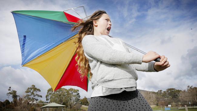
The Bureau of Meteorology has issued a severe weather warning for damaging south-westerly winds across much of Tasmania during Saturday.
Tasmania
Don't miss out on the headlines from Tasmania. Followed categories will be added to My News.
UPDATE: DAMAGING south-westerly winds are expected across much of Tasmania during Saturday, with peak gusts of 100 km/h possible.
A severe weather warning issued by the Bureau of Meteorology on Friday morning said a very deep low pressure centre is set to cross southern Tasmania early Saturday, with strong south to south-westerly winds to follow.
Locations which may be affected include Devonport, Burnie, Swansea, Strahan, New Norfolk and Hobart.
“Damaging south-westerly winds, averaging 60 to 70 km/h with peak gusts around 100 km/h, are possible across much of Tasmania apart from parts of the North-East,” the warning reads. “Gusts in excess of 100 km/h are possible about elevated areas as well as exposed coastal areas.
“The strongest gusts are expected to develop very early Saturday morning, with winds beginning to ease later in the day.”
Damaging surf is also expected along coasts about the far South and South-East, as well as King Island.
“Damaging surf, which may lead to localised damage and coastal erosion, is possible along coasts about far South and South-East Tasmania as well as and King Island (including Tasman Peninsula, Bruny Island and Currie),” the warning continued.
“Damaging surf is expected mainly along the west to south facing coasts in these areas.
“Note that tides about south and southeastern Tasmania are expected to be higher than the usual tide, so local inundation may occur with damaging surf.”
THE STATE EMERGENCY SERVICE ADVISES THAT PEOPLE SHOULD:
* Supervise children closely.
* Check that family and neighbours are aware of warnings.
* Manage pets and livestock.
* Secure outdoor items including furniture and play equipment.
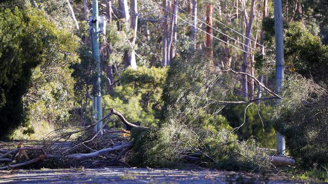
* Be prepared in case of power outages and report any outages to TasNetworks on 132 004.
* Beware of damaged trees and power lines and take care when driving.
* Surf Life Saving Tasmania advises no swimming in areas exposed to large surf.
* Listen to the ABC radio or check www.ses.tas.gov.au for further advice.
* For emergency assistance contact the SES on 132500.
EARLIER: WINTER is well on its way as Tasmania braces for a cool, wet and windy weekend.
Bureau of Meteorology meteorologist Luke Johnson said although the cold weather would not hit Tasmania quite as badly as the mainland, the state still needed to brace for the chilly conditions.
“We’re expecting very cold, wintry conditions and wet conditions for the rest of this week and into Saturday for Tasmania,” he said.
“With the peak of the cold air coming over us later Friday and early Saturday morning, we’re likely to see snow drop to around 800 metres.”
MORE NEWS:
TIGER KING’S TAKE ON THE THYLACINE
SPEAKER OF THE HOUSE SUSPECTED OF COVER-UP
HOW THE VIRUS SPREAD THROUGH THE NORTH-WEST
Intermittent showers are expected throughout the state until Saturday, and thunderstorms and hail could be possible for the North and West of the state.
Mr Johnson said in the South and East, rainfalls from Thursday to Saturday were expected to total 2-10mm, in the North 5-15mm, and in the West and far South 40-80mm.
Hobart’s forecast top of 11 degrees on Saturday is expected to be the coldest day since September 7.
He said wind gusts on Saturday could reach 90 to 100km/h, with a severe weather warning for damaging winds possible to be required.

‘Evolution’: Pumphouse Point to unveil two luxe new stays
One of Tasmania’s premier nature-based hotels, Pumphouse Point, has unveiled two new boutique accommodation offerings on the edge of Lake St Clair.

Unions still asking if Premier supports privatisation
“When you change your position on an issue by 180 degrees, it’s reasonable for people to ask some questions”: Unions are still questioning the Premier’s privatisation stance, up to the day of voting polls opening.