
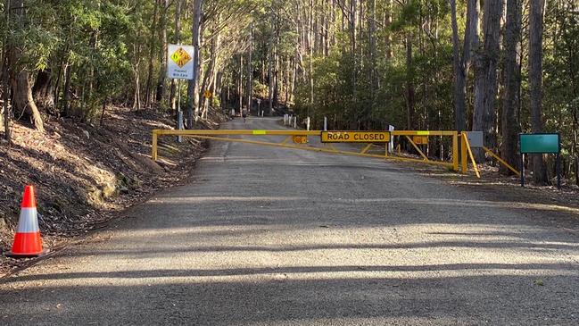
Road to Mount Wellington closed due to strong weather
Gusts of 150km/h have already been reported this morning, as the Bureau warns Tasmanians more wild weather — including hail and snow — is on the way this afternoon and tonight. FULL FORECAST + VIDEO >>
Tasmania
Don't miss out on the headlines from Tasmania. Followed categories will be added to My News.
The strong cold front is crossing Tasmania this morning, with strong and gusty west to north-westerly winds being felt across the state.
The Bureau of Meteorology warns a colder south-westerly change is coming during the day, with strong winds and snow falls possible down to 500 metres this afternoon.
Hail is also possible in the south this evening, the Bureau says.
Get ready for a #wintery blast #Tasmania. #Snow is expected to fall as low as 500m on Tuesday afternoon, with gusty and potentially damaging #winds during the day. Bushwalkers Alert, Sheep Graziers Warning and Severe Weather Warnings are current at https://t.co/ItqnPP0O23 pic.twitter.com/AWsktal9mf
— Bureau of Meteorology, Tasmania (@BOM_Tas) June 15, 2020
Already, 150km/h wind gusts have been reported at Maatsuyker Island, with 81km/h gusts in Hobart and 96km/h recorded at kunanyi/Mount Wellington.
The road to Mount Wellington has been closed to motorists due to the severe weather.
Further damaging gusts in excess of 100km/h is possible about southern, eastern and northern Tasmania throughout today.
LATEST NEWS:
- Bandidos members charged over $500,000 Spirit ice bust
- Border battleground as opening date remains a mystery
A severe weather warning for damaging winds is current for southern, eastern and northern Tasmania with other strong gusts recorded so far today including:
- 119km/h at Mount Read
- 115km/h at Scotts Peak
- 109km/h at Low Rocky Point
- 104km/h at Cape Grim
- 98km/h at Cape Bruny
- 96km/h at kunanyi/Mount Wellington
- 91km/h at Maria Island
- 81km/h at Hobart
Rainfall continues with 10–20mm forecast in the west and far south today, up to 30mm possible in elevated areas, 5–10mm in elevated areas of the north east and 2–5 mm elsewhere.
Temperatures will cool tonight with overnight minimums to reach subzero temperatures in central areas bringing a high likelihood of frost.
Locations which may be affected include Devonport, Launceston, St Helens, Swansea, Strahan, New Norfolk and Hobart.
The State Emergency Service advises that people should:
- Supervise children closely.
- Check that family and neighbours are aware of warnings.
- Manage pets and livestock.
- Secure outdoor items including furniture and play equipment.
- Be prepared in case of power outages and report any outages to TasNetworks on 132 004.
- Beware of damaged trees and power lines and take care when driving.
- For emergency assistance contact the SES on 132500.
A sheep graziers warning is current for the Upper Derwent Valley and South East districts on Tuesday due to the wet, cold and windy conditions.
A bush walkers alert is also current for the Western forecast district due to the low-level snow.
Hobart forecast
Rest of today: Cloudy. Very high (90%) chance of showers, most likely during the morning and afternoon. Possible hail in the south this evening. Winds north-westerly 30 to 35 km/h turning westerly 30 to 45 km/h in the late morning and afternoon.
Wednesday: Min 5 Max 12. Partly cloudy. Winds westerly 25 to 35 km/h becoming light early in the morning.
Thursday: Min 2 Max 13. Mostly sunny. Areas of morning frost. Light winds.
Friday: Min 5 Max 15. Partly cloudy. Light winds.
Saturday: Min 6 Max 14. Cloudy. High (70%) chance of showers. Light winds.
Sunday: Min 8 Max 14. Cloudy. Medium (60%) chance of showers. Light winds.
Launceston forecast
Rest of today: Cloudy. Very high (90%) chance of showers during the morning and afternoon. Winds north-westerly 35 to 55 km/h tending west to north-westerly 25 to 35 km/h in the late afternoon then becoming light in the late evening.
Wednesday: Min 1 Max 12. Partly cloudy. Areas of morning frost. Light winds.
Thursday: Min 3 Max 13. Cloudy. Slight (20%) chance of a shower. Light winds.
Friday: Min 7 Max 16. Cloudy. Slight (30%) chance of a shower. Light winds.
Saturday: Min 6 Max 15. Cloudy. Very high (90%) chance of showers. Light winds.
Sunday: Min 5 Max 15. Cloudy. Medium (50%) chance of showers. Light winds.

Election counting continues, result likely in two weeks
It is a nervous wait for some candidates in Saturday’s election but the make-up of the House of Assembly should be known by August 2. The latest from the TEC.

Tassie’s snow show
After the dumping of vote ballots on Saturday, Tasmania braced itself for an overnight dumping of fresh snow on the major peaks. What’s in store for the week ahead.