
Heavy rainfall, damaging winds forecast for northern Tasmania
Severe weather warnings have been issued as Tasmania braces for heavy, flooding rain and damaging winds of 100km/h. SEE THE WARNINGS >>

Tasmania
Don't miss out on the headlines from Tasmania. Followed categories will be added to My News.
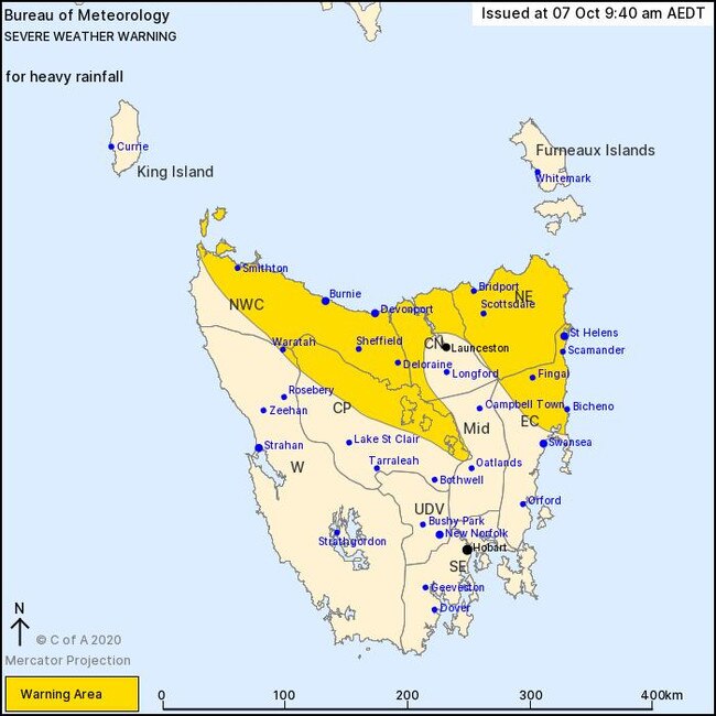
Northern and upper eastern Tasmania are set for a wild day of weather, with a number of warnings issued for strong winds and heavy rain that may lead to flash flooding.
The Bureau of Meteorology said a deep low pressure centre will develop near King Island on Thursday, directing a strong, moisture-rich easterly airstream over Tasmania throughout the day.
The low will move over the state and away to the southeast during Friday.
Heavy rainfall which may lead to flash flooding may develop across parts of northern Tasmania, as well as parts of the upper east and central highlands during Thursday.
BOM is forecasting 60 to 90mm of rainfall is expected throughout those areas, with higher falls possible about elevated areas in the northeast.
>> GET A MERCURY DIGITAL SUBSCRIPTION FROM JUST $1/WEEK
The heaviest rain is expected to occur during the late morning and the afternoon, with rain easing during the evening.
Soils and catchments are very wet across much of northern Tasmania, so rainfall run-off, flash flooding and river rises may occur more easily.
It will be a rainy day right across Tasmania tomorrow, with totals of 10–20mm forecast for remaining areas of the state.
>> FLASH SALE: $89 flights to tropical destination
BOM said damaging north-easterly winds averaging 50–60km/h would impact most of the
state tomorrow with peak gusts of 90–100km/h possible at times.
Thunderstorms are possible for the Bass Strait islands and the northeast.
Flood warnings are current for the Macquarie River, Jordan River, Coal River and
River Derwent following a wet weekend.
The Bureau said conditions would slowly improve from Friday, but rain will continue to fall with 20–40mm forecast in the west, 10–20mm in the north and locally higher falls possible
in the northeast, and 5–10mm elsewhere.
Significant weather is expected across Tasmania tomorrow. A Severe Weather Warning for Heavy Rainfall has been issued for parts of northern Tasmania, and a Severe Weather Warning for Damaging Winds has been issued for much of the state. More info here: https://t.co/NHL3HY0zFO pic.twitter.com/ryoxv0ga4j
— Bureau of Meteorology, Tasmania (@BOM_Tas) October 7, 2020
The rainfall on Thursday and Friday may result in flash flooding and further riverine rises with soils and catchments already wet in northern and eastern Tasmania.
BOM said people travelling for school holidays, especially those visiting unfamiliar areas,
should pay attention to warnings and drive to conditions.
“People located in the forecast areas can expect heavy rainfall, particularly during late Thursday morning through to the late afternoon,” SES Northern Regional Manager Mhairi Revie said.
“Damaging east to north easterly wind gusts up to 80-100km/h are forecast. Rainfall catchments across the State are already wet, meaning that these winds will likely cause trees and tree limbs to fall.”
Ms Revie advised that road users should be particularly vigilant as road conditions may be dangerous.
“It is likely that there will be water on and around roads, and drivers also need to be cautious of debris on roads. This reminder is particularly timely during these times of school holidays when our roads are extra busy, with people travelling on roads unfamiliar to them.”

UTAS takes out top spot in global ranking
The University of Tasmania has once again excelled in the Time Higher Education Impact Rankings, retaining its position as the world’s number one educational institution for climate action.

Mayor, former Tasmanian of the Year unveiled as Labor candidates
Labor has announced its state election candidates for Clark, Franklin, and Lyons, tapping several prominent community leaders to help the Opposition win government.