
Hobart floods: Havoc as wild weather floods city and Tasmania’s South East
UPDATED: POWER has been restored to nearly all homes across Tasmania with residents being warned to watch out for hidden hazards when they return to flood-affected homes. Emergency service crews conducted three rescues during the overnight flood event that stunned Hobart with its ferocity. MEGA GALLERIES, VIDEOS
Tasmania
Don't miss out on the headlines from Tasmania. Followed categories will be added to My News.
A RECORD 236.2mm of rain fell on kunanyi/Mt Wellington in the 24 hours to 9am and 129.2mm in Hobart.
The deluge flooded the city as the Hobart Rivulet broke its banks and lower lying areas in Sandy Bay, South Hobart, New Town, Lenah Valley and Kingston were also flooded.
Cars were swept away in Collins St and Syme St and McRobies Rd in South Hobart.
Homes lost their roofs in Sandy Bay as winds lashed the city and SES crews responded to more than 280 calls.
MORE: HOW THE FLOOD DRAMA UNFOLDED
MORE ‘A WALL OF WATER CAM CRASHING THROUGH’
MORE: FLOOD RECOVERY COULD TAKE MONTHS
MORE: TOWN CUT OFF FOR THREE DAYS
EARLIER: POWER has been restored to nearly all homes in the Hobart area with just a few homes around Sandy Bay still affected.
EARLIER: NEARLY 10,000 homes remain without power across Tasmania tonight as TasNetworks carries out repairs to significantly damaged infrastructure.
About 30 power lines remain down after the heavy winds and floodwaters swept across the state’s south with close to 9500 homes still without power around Hobart, the Tasman Peninsula, Kingborough, the Glenorchy municipality, the Derwent Valley and even some suburbs around Launceston.
TasNetworks said if a customer is without power after 9pm, that power supply will remain off overnight.
“If a customer’s power is restored before 9pm, power may still be intermittently interrupted overnight,” the utility said.
“Our crews will remain working overnight to assess damage and make safe with further restoration work beginning at 8am.”
People without power can seek alternative accommodation with family and friends or head to the recovery centre at 108 Bathurst St, Hobart.
All water-damaged property requires sign-off by a licensed electrician before reconnection can be arranged. Property owners must provide TasNetworks with a Certificate of Electrical Compliance before reconnection.
People must remain 10m away from downed power lines and and report them to 132 004.
EARLIER: EMERGENCY services will continue working over the weekend after a huge number of requests for assistance as a result of the severe weather event around Hobart, police say.
SES crews have received 395 requests for assistance since last night. They have attended 373 with 22 outstanding.
Tasmania Police said the SES was in contact with those with whose requests were outstanding, and they are being prioritised accordingly.
EARLIER: RESIDENTS are being warned to watch out for hidden hazards when they return to flood-affected homes.
Tasmania Police said people needed to contact TasNetworks if their power was still on and they believed their homes had been water damaged.
“If your power has been restored, be aware your electrical appliances may be water damaged and present a danger and need to be checked by a qualified electrician,” police said.
“Also be aware of contaminants, biohazards and debris.”
Emergency services have received more than 300 calls for assistance with wind damage to roofs and sheds and trees blown over. There have been flash flooding events in Blackmans Bay, Kingston, Sandy Bay and the Hobart CBD.
SES crews – including from the North and North-West – are continuing to work through requests for assistance. There are no reports of injuries.
An evacuation centre remains open at Mathers House at 180 Bathurst St (next to the State Library) for people requiring information support or shelter. The Kingston centre has now closed.
While conditions are expected to ease in the south later today, motorists are strongly urged to avoid unnecessary travel in the CBD, New Town and Sandy Bay areas.
Major roads in the CBD are still significantly affected by floodwaters and debris, and power outages are affecting some traffic lights. The roads are unlikely to be open for several hours.
Only people with medical emergencies should present at the Royal Hobart Hospital.
Significant delays are expected across the CBD as roads remain closed during peak
hour. Emergency crews also require access to the roads to clear debris.
EARLIER: EMERGENCY service crews have conducted three rescues among hundreds of call-outs during an overnight flood event that stunned Hobart with its ferocity.
Tasmania Fire Service deputy regional chief Greg Butters told reporters today there had been more than 110 fire calls, the majority of which were for building alarms.
“We also assisted SES and Tasmania Police with two rescues, one gentleman out at Risdon Rd trapped in his vehicle and also a worker at UTAS was trapped in a room that was swelling so we had to break in and rescue him,” Mr Butters said.
“Neither of them were serious, however the gentleman that was trapped in a room at UTAS due to an electrical fault, he couldn’t get out the door, so the water was rising when the firefighters got there.
“The water was about a metre off the floor, they forced entry, and that gentleman was rescued.”

The man was not injured, but was understood to be quite shaken.
The second rescue was of an unknown number of people trapped in a car at Risdon Rd after they ignored the floodwater warnings.
Then the Westpac chopper was called to New Norfolk this afternoon to retrieve a 15-year-old boy stranded on an inundated cricket oval at Tynwald Park.
MORE: CHOPPER PLUCKS STRANDED BOY FROM FLOODWATERS
Mr Butters said it was miraculous that no one was seriously hurt in the floods.
State Emergency Service director Andrew Lea said the SES had received more than 300 requests for assistance since 6pm yesterday.
Mr Lea said the municipalities of Glenorchy, Clarence, Hobart, and Kingborough had been hit the hardest, but requests for assistance had come from as far north as Spring Bay and as far south as Huonville.

About 80 SES workers were responding to the floods, with a further eight volunteers travelling down from both the North and the North-West.
“I’ve been in this job for 17 years and I haven’t seen an event of this scale in the Hobart area, so it very significant,” Mr Lea said.
Tasmania Police Commissioner Darren Hine said police had received more than 280 calls for assistance, but were not aware of any reports of injury.
He said most people had heeded the weather warnings.
“Unfortunately there have been a few instances where motorists have ignored road closed signs, we have booked at least one person and possibly more in relation to ignoring road closed signs,” Commissioner Hine said.
Bureau of Meteorology acting state manager Simon McCulloch said South-East of Tasmania experienced an “exceptional rainfall event” over the past 24 hours.
“To put it into historical perspective, Hobart has had 129mm of rain since 9am [Thursday], which is the fourth highest on record and only the fifth time since 1882 that Hobart’s had over 100mm of rain in the one day,” Mr McCulloch said.
Premier Will Hodgman praised the efforts of the emergency services.
“The response has not only been rapid but very well co-ordinated, and I want to thank our emergency services personnel across the board for their vigilance and for their effective response in what are, clearly, quite extraordinary services,” Mr Hodgman said.
EARLIER: The Royal Hobart Hospital was put on an emergency footing as it dealt with the wild storm that lashed the capital overnight.
A code yellow, signifying an internal emergency, was called by hospital management to co-ordinate a response to the severe weather.
The RHH’s emergency department sustained some water damage but remains open.
Three beds were closed in the intensive care unit and six in paediatrics.
The day surgery ward sustained water damage, while lifts in two blocks are being repaired after they broke down.
“There have been numerous instances of water leaking and flooding across the hospital,” the Tasmanian Health Service’s Susan Gannon said.
Surgery is continuing but some appointments could be affected following the massive storm.
A statement from the Royal said all elective and day surgery would take place as scheduled.
“For anyone who has an outpatient’s appointment, you will be contacted if your appointment has been cancelled,” Ms Ganno said.

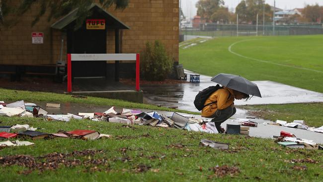
Meanwhile, the University of Tasmania remains in the early stages of assessing the impact of flooding at its Sandy Bay campus.
The campus has been closed and locked down after floodwater inundated the law and engineering faculties overnight.
Books from the law library have been left scattered throughout the carpark and nearby oval.
About a foot of water inundated the law library, with mud spread over lower shelves and furniture inside.
A UTAS spokesman said at this stage the University was focused on ensuring the safety of staff and students, but was likely to have further comment later today.
EARLIER: SEVERAL people were rescued from floodwaters in Hobart overnight, with emergency service crews pleading with motorists to avoid driving through inundated areas.
Tasmania Fire Service crews helped police rescue two people whose car became trapped at Risdon Rd, New Town.
A Tasmania Police spokesman said firefighters also rescued a security guard from an alarm monitoring room at UTas Sandy Bay campus.
He was trapped as the room, which had no windows, filled with water.
The man was luckily uninjured.
“Quick action by firefighters also prevented a boat from sinking at Kings Pier marina,” he said.
“Motorists are strongly urged to avoid unnecessary travel in the CBD, New Town and Sandy Bay areas.”
The spokesman said major roads in the CBD were significantly affected by floodwaters and debris, and power outages were affecting some traffic lights.
“The roads are unlikely to be open for several hours,” he said.
Sandy Bay Rd between Nelson Rd and Maning Ave in Sandy Bay is closed until further notice, with vehicles originally asked to use Churchill Ave as an alternative route.
Police now ask motorists to avoid the area altogether if possible as congestion is building, causing long delays.
FOR THE LATEST ROAD CLOSURES, CLICK HERE
“It is requested that people with medical emergencies only present at the Royal Hobart Hospital.”
SES crews are continuing to work through requests for help but there are no reports of injuries.
Surgery is continuing at the Royal Hobart Hospital but some appointments could be affected following the massive storm that hit the capital overnight.
A statement from the RHH says all elective and day surgery will take place as scheduled.
“For anyone who has an outpatient’s appointment, you will be contacted if your appointment has been cancelled,” a spokeswoman said.
“Anyone who can’t get the RHH for an appointment today will have their appointment rescheduled.”
For help, phone:
SES 132500
Life-threatening emergencies 000
Police non-emergencies 131444
EARLIER: Insurer RACT has already received 10 times the average number of claims in the wake of Hobart’s night of storm mayhem.
The company says the claims began overnight as torrential rain and strong winds battered the capital, with more expected today.
A record 236.2mm of rain fell on kunanyi/Mt Wellington in the 24 hours to 9am and 129.2mm in Hobart.
FOR THE LATEST ROAD CLOSURES, CLICK HERE
The deluge flooded the city as the Hobart Rivulet broke its banks and lower lying areas in Sandy Bay, South Hobart, New Town, Lenah Valley and Kingston were also flooded.
Cars were swept away in Collins St and Syme St and McRobies Rd in South Hobart.
Homes lost their roofs in Sandy Bay as winds lashed the city and SES crews responded to more than 280 calls.
RACT Insurance CEO Trent Sayers is urging Tasmanians to put their safety first with the bad weather set to continue.
“Tasmania, along with the south east coast of Australia has experienced damaging winds and significant rainfall over the past 24 hours, and we expect this to result in an increase in property and vehicle damage,” said Mr Sayers
“If you have experienced flooding, please remember that safety is the number one priority and stay away from coastlines, tidal areas and to avoid driving through flood water.
“We have enacted our event response plan and our claims staff and services are positioned and ready to respond.”


TasWater is urging the public to be cautious with flood waters.
“People are reminded that any flood waters may contain sewage and to avoid contact for health and safety reasons and to follow the safety advice distributed by the SES in relation to flood hazards,” a spokesman said.
TasWater staff are receiving a high volume of calls and are only able to respond to the most urgent incidents.


“Once the weather has improved sufficiently, TasWater crews can assess the full impacts of the event,” the spokesman said.
EARLIER: POLICE have cautioned motorists against unnecessary travel into Hobart’s CBD and the New Town and Sandy Bay areas as wild weather continues to lash southern Tasmania.
In a statement issued early today, Tasmania Police said major roads in the CBD were significantly affected by floodwaters and debris, and power outages meant some traffic lights were not operating.
“The roads are unlikely to be open for several hours,” police said.
FOR THE LATEST ROAD CLOSURES, CLICK HERE
“It is requested that people with medical emergencies only present at the Royal Hobart Hospital.
“Significant delays are expected across the CBD as roads remain closed across peak hour.
“Emergency crews also require access to the roads to clear debris.
“Many roads are affected by floodwaters and debris. Stormwater has overflowed,
contaminating the floodwaters.”
More than 10,000 homes are in southern Tasmanian are without power as a result of the severe weather conditions.
Schools that have been confirmed as closed as of 6.30am are: Blackmans Bay Primary School, Elizabeth College, Goulburn St Primary School, Hobart College, Huonville High School, Illawarra Primary Primary School, Lenah Valley Primary School, Margate Primary Schooll, Mt Nelson Primary School, Princes St Primary School, Sandy Bay Infant School, South Hobart Primary School, Taroona High School, Taroona Primary School, Tasman District School, and Waimea Primary School.
The University of Tasmania has closed all its southern campuses including Sandy Bay, the Menzies Centre and IMAS.
Check here for updated school closures.
Bureau of Meteorology forecaster Debbie Tabor said the state was still under the influence of an intense low east of Flinders Island.
“Rainfall is locally heavy about the eastern, southern, and central areas this morning, things will ease this afternoon and then contract to the north-east tonight,” Ms Tabor said.
“We’ll still have some showers left around, but the heaviest falls are likely to be this morning in the south and then along the east coast in the afternoon.
“There is the possibility of thunderstorms in the south and the east also.”
Hobart has had 128mm of rain since 9am yesterday.
Leslie Vale and Mt Wellington have both had 222mm, and Grove, in the Huon Valley, 156mm.
“I think the last time [Hobart] reported this much rainfall was in 1960 on the 23rd of April of 132mm, so we’re 4mm off that record,” Ms Tabor said.
SEE ALL THE LATEST ROAD CLOSURES
MORE EMERGENCY INFORMATION
To report life-threatening emergencies, dial triple-0 (000)
To report flood and storm damage or to request SES assistance, call 132 500
Visit the State Emergency Service website www.ses.tas.gov.au
Visit the TasALERT website: www.tasalert.com
For current river levels and weather conditions, check the BoM website: www.bom.gov.au/tas/
Listen to your local ABC radio station for updates.
For more information on preparing for flood, visit www.ses.tas.gov.au
Current reported road closures are listed on the Tasmania Police website: www.police.tas.gov.au
UPDATED 5am: EVACUATION centres have been set up and emergency crews are dealing with hundreds of calls for help as southern Tasmania continues to be slammed by a storm of incredible fury.
Hobart copped the brunt of an extreme weather event overnight, with motorists being advised to avoid unnecessary travel this morning as authorities are faced with a massive clean-up.
At current estimates, Hobart received 126mm of rain to 4am and more is expected today.
The Hobart Rivulet broke its banks at the corner of Campbell and Collins streets about 2am, resulting in the closure to the lower part of the CBD.
Council officials are still trying to determine what streets will be closed to motorists as the early peak hour begins.

Earlier yesterday evening, authorities reported the rivulet had risen to unprecedented levels, breaking its banks and swamping vast areas of South Hobart and the CBD.
While that subsided in the early hours of the morning, fast-flowing water downstream saw it then break its 100-year-old banks at the corner of Collins and Campbell before spilling into Macquarie St and right through to the waterfront.
At least six parked cars were swept aside as the raging torrent made its way to the docks.

Hobart City Council workers on the scene could only watch helplessly at the force of the water took everything in its path.
A worker, who would not be named, said he had seen a similar event once before in the 1950s.
While some roads were blocked off early in the evening, police are continuing to monitor the situation.
The rivulet is expected to peak and break its banks again this morning and council workers said they could not predict whether more flash flooding was likely.
They said residents on the ground floors of the lower area of the CBD had been notified of the situation, but were not deemed to be in harm’s way.

The State Emergency Service has set up evacuation centres for those who cannot remain in their homes because of storm damage.
“Emergency services have received hundreds of calls for assistance – wind damage to roofs and sheds and trees blown over,” police said in a statement issued in the early hours of this morning.
“There have been flash-flooding events in Blackmans Bay, Kingston, Sandy Bay and the Hobart CBD.
“SES crews have been triaging calls and responding to the most urgent. Crews are continuing to work through requests for assistance.
“SES advises that evacuation centres have been established at Mathers House at 180
Bathurst Street (next to the State Library) and in Kingston at 99 Beach Road (behind
Raine and Horne Real Estate) for people requiring information support or shelter. Local
council staff will be available to assist.
“The weather event is persisting and further wind and heavy rain is expected between
8am and midday, and people are urged to be prepared and avoid unnecessary travel.”

Roads are significantly affected by floodwaters and road closures include;
The lower end of Macquarie St, Davey St between Campbell and Argyle St
Argyle between Campbell and Burnett
Brooker Hwy between Brisbane and Warwick
Channel Hwy between Browns Road and Beach Road
Risdon Rd, Morrison Street between Murray and Castray
Sandy Bay Road between Waimea and Derwent Water Avenues
Salamanca Place
McRobies Rd
Many other roads are also affected by floodwaters and debris.
For assistance call:
SES 132500
Life-threatening emergencies 000
Police non-emergencies 131444

EARLIER: MORE heavy rain, strong winds and possible flooding is forecast across parts of Tasmania as a wild night of weather caused havoc overnight.
The storm affected flights, caused power outages and flooding, swept away cars, uprooted trees and contributed to road crashes.
Hobart copped a deluge with 79mm of rain in just five hours causing flash flooding across the city. Flooding hit Salamanca, Collins St next to the Royal Hobart Hospital and the New Town Rivulet also burst its banks across Risdon Rd near the Brooker Highway, which was also flooded near Cleary’s Gates.
Cars were swept down the road and left flooded as the Hobart Rivulet broke its banks, flooding Collins and Campbell Streets. The flooding also set off sirens across the CBD.
Water also inundated the University of Tasmania Engineering building, with dramatic footage captured by Bryce Cui (see below).
At 10.30pm, about 14,000 homes were without power around Hobart, Kingston, Blackmans Bay, Tasman Peninsula, South Arm, Bruny Island, Berriedale, Cygnet and Derwent Valley areas due to the wild weather.
SEE ALL THE LATEST ROAD CLOSURES
At 11.20pm, Hobart had recorded 94.4mm since 9am and higher up the slopes on kunanyi Mt Wellington 137mm had fallen.
TasNetworks crews have been busy trying to restore power and updates can be found on its website.
The Rheban Rd Bridge at Orford was flooded while Highland Lakes Rd and Poatina Rd in the Central Highlands were closed due to snow.
SES assistant director Leon Smith said a Southern Regional Operations Centre was established last night to monitor calls.
NEVER MISS A STORY WITH THE MERCURY APP
By 10.30pm more than 50 calls for assistance had been made around the southern area to deal with to dislodged sheds and roofing as well as trees falling on to buildings.
Lightning, thunder and hail was also recorded around the Hobart area last night.
A Hobart airport spokesman said one Qantas flight was forced to return to Melbourne with three other inbound flights delayed. He said this had also caused delays to departing flights.
There was also a three-car crash on the Tasman Highway at Mornington last night.
The parched East Coast was hit hardest by the rain yesterday, with some serious drenching to continue today.

A severe weather warning for damaging winds of up to 100km/h will remain active across most of the state today. Heavy rain is also forecast for the east and southeast early today, with flash flooding possible, including for Hobart.
A flood watch is active for catchments in the North, NorthEast, East Coast, central and southeast areas, with a minor flood warning active for the Huon River. Thunderstorms are again forecast.
A deep low centred off Tasmania’s south east brought steady rain, with Buckland recording 106mm, Nugent 102mm, Triabunna 84mm and Maria Island 82mm.
Other sites to receive significant falls have been Grove (53mm), Little Swanport (47mm), Campania (45mm), Friendly Beaches (33mm), Fingal (30mm), Dunalley (31mm) and Tunnack (28mm).
The highest recorded wind gusts were on Mt Wellington (132km/h), Maria Island (107km/h), Bruny Island (106km/h), Campania (89km/h) Hobart (85km/h) Bushy Park (80km/h) and Dunalley (72km/h).
MORE EMERGENCY INFORMATION
To report life-threatening emergencies, dial triple-0 (000)
To report flood and storm damage or to request SES assistance, call 132 500
Visit the State Emergency Service website www.ses.tas.gov.au
Visit the TasALERT website: www.tasalert.com
For current river levels and weather conditions, check the BoM website: www.bom.gov.au/tas/
Listen to your local ABC radio station for updates.
For more information on preparing for flood, visit www.ses.tas.gov.au
Current reported road closures are listed on the Tasmania Police website: www.police.tas.gov.au
BoM supervising meteorologist David Matthews said the East, South East and Central parts of the state were expected to receive 30-60mm today, with isolated rainfall totals up to 80mm.
“There’s a low pressure system that’s formed off the East Coast of Tasmania producing strong and gusty south to south-easterly winds, which are bringing heavy rainfall into the eastern half of the state,” he said.
“Strong and dangerous flows and rapid rivulet rises are expected in small creeks and catchments in locations that receive heavy rainfall. “We will see the rain begin to ease during [this] afternoon.”
At 10pm last night the Huon River was at 1.9m and steady, 1m below minor flood level.
Mr Smith said crews were on standby for any possible issues relating to flooding.
“Nothing of alarm is happening at this stage, we expect it to be fairly benign ... but we’ll monitor the situation.”

Debbie Armstrong, who owns NVS hairdressing in Huonville, spent yesterday making preparations to protect her salon after losing everything during a similar weather event in June 2016.
“We’ve lifted everything that might be on flood level up to bench height, emptied cupboards, and put furniture on milk crates,” she said.
The wild weather has also impacted “tent city” at the Hobart Showground. Royal Agricultural Society of Tasmania chief executive Scott Gadd said he had to open buildings for people to shelter in after tents were inundated by yesterday’s downpour.
A road weather alert is also active across the Central Plateau, Midlands, East Coast, upper Derwent Valley and South East today. Showers are forecast in Hobart tomorrow but will ease Sunday, with a cloudy weekend forecast for Launceston.

‘Bad for democracy’: Integrity Commission drops plans to update state’s lobbying laws
Tasmania’s Integrity Commission remains tight-lipped about its decision to abandon the implementation of new rules for the state’s lobbying industry.

‘Disrespectful’: Margaret’s husband died while on the home care wait list
Margaret Poulter’s late husband, Tony, had been assessed as eligible for a home care package a year before he died but was only approved when he had days left to live. WIDOW’S FIGHT FOR CHANGE >>>