
Damaging winds, heavy rains and floods forecast for Thursday
The outlook for Thursday has ramped up since yesterday, with those travelling for the school holidays warned of flooding and strong winds. SEE THE FULL WARNINGS >>

Tasmania
Don't miss out on the headlines from Tasmania. Followed categories will be added to My News.
- Prison poo: Sewage spills on Risdon Prison grounds
- ‘It’s devastating’: Tributes for crash victim who lost house in Dunalley fires
UPDATE:
The outlook for Thursday has ramped up since yesterday, with those travelling for the school holidays now bracing for flooding and strong gusts.
Clear, calm conditions today and tomorrow have brought frost warnings for parts of the state, with early rising Hobartians experiencing a low of 1.9 degrees this morning.
But Thursday will see the blustery weather return.
Morning #Tasmania!
— Bureau of Meteorology, Tasmania (@BOM_Tas) October 5, 2020
The #weather will be fairly settled today and tomorrow, but there's rain a comin' on Thursday courtesy of a low pressure system.
Amounts will depend on the low's location - stay tuned!#forecast at https://t.co/uWHObb6wlu pic.twitter.com/8uciXVjzg1
Previous forecasts estimating between 30 to 50mm of rainfall have now jumped to 30 to 70mm around the north and east, with the potential for higher falls still in elevated areas.
Peak gusts in the same areas are predicted to reach 100km/h.
Just after 1.15pm today, Tasmania Police advised Clifton Vale Road between Elderslie and Cockatoo Gully Road is closed due to flooding.
The turbulent weather comes just days after heavy rains from Sunday and Monday soaked the state, which led to flooding at Sorell Rivulet and sewage spills on and around Risdon Prison grounds.
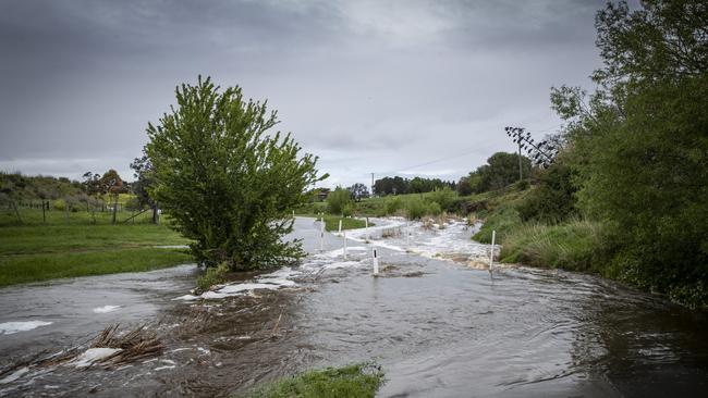
The Bureau of Meteorology says the recent rainfalls will increase the likelihood of flash flooding and riverine rises on Thursday, with flood warnings remaining for the Macquarie River, Jordan River, Coal River and River Derwent.
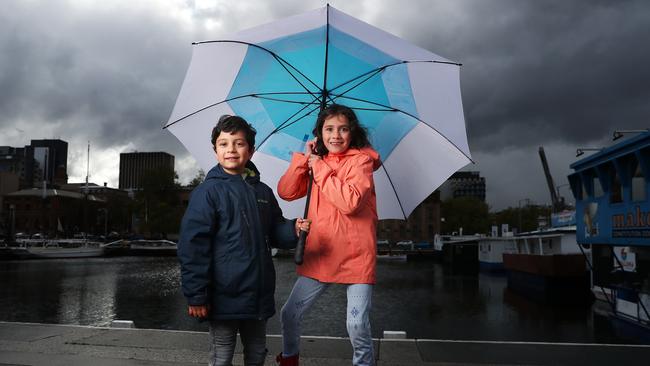
“People travelling for school holidays, especially those visiting unfamiliar areas, should pay attention to warnings and drive to conditions,” BOM said.
Other areas will experience 10-20mm on Thursday as a slow-moving low-pressure centre passes over the state.
EARLIER: YOU may have noticed the heavy rains beginning to thin out today, but the Bureau of Meteorology has warned we haven’t seen the last of the wet and wild weather this week.
Between 40 and 70mm of rain has hit southern and western areas of Tasmania over the last three days, while the northeast levels remained under 10mm.
BOM recorded as much as 6cm of snow atop the Central Plateau this morning.
The rainband that's been sitting over #TAS on weekend (blue in this enhanced IR sat image) is moving away to the east today. It's being pushed aside by cooler SW winds and lighter more isolated showers (speckled grey cloud). https://t.co/sE8cPnCNXP pic.twitter.com/6b9ZNHr8cK
— Bureau of Meteorology, Tasmania (@BOM_Tas) October 4, 2020
Snow settled elsewhere above 700m this morning, with Tasmanians likely to have felt a chill in the air after getting up an hour earlier than usual following the recent daylight savings switch.
Minor flood warnings remain for the Jordan River, Coal River, North Esk River and River Derwent despite mostly fine weather expected for Tuesday and Wednesday.
The fine weather will bring with it morning frost to much of Tasmania, with frost warnings for the Midlands and Upper Derwent Valley.
âš ï¸Initial Minor #Flood Warning issued for #Derwent River catchment for Monday. See https://t.co/V9LYfDAYDq for details and updates; follow advice from @SESTasmania. #TasFloods pic.twitter.com/xfBZaub8ci
— Bureau of Meteorology, Tasmania (@BOM_Tas) October 4, 2020
Downpours will return on Thursday estimated to reach 30 to 50mm about northern and eastern parts of the state.
The wet weather and strong north-easterly winds will continue into Friday due to the slow-moving, low-pressure centre moving over the state.
The northern and eastern affected zones can expect flood warnings later this week as catchments and soils are already drenched.
For the latest forecasts and warnings visit bom.gov.au/tas and follow @BOM — Tas on Twitter.

‘Reputation in tatters’: Former Miss Australia weeps in court
Kathryn Hay was once a respected Labor MP, now the former Miss Australia’s ‘reputation is in tatters’. She wept in court during sentencing for the emotional abuse of her former husband.

Archie’s gift: Teesdale blesses kind act
A simple, instinctive act of kindness from a small boy has underlined the importance of caring and of human connection for new Bass MP Jess Teesdale.