
Ferries, self-driving cars and more cycles ways are part of RACT’s 30-year vision for Hobart’s CBD
PARK-and-ride services, ferries between the CBD and Eastern Shore and funding for major infrastructure projects are part of a 30-year plan to help solve Hobart’s traffic woes. SEE THE VIDEO
Tasmania
Don't miss out on the headlines from Tasmania. Followed categories will be added to My News.
PARK-and-ride services, ferries between the CBD and Eastern Shore and self-driving vehicles are part of a 30-year plan to help solve Hobart’s traffic woes.
The RACT has revealed its 30-year traffic plan to drastically reshape how Tasmanians interact with the CBD.
Overall, the staged plan will gradually shift Tasmanians from being highly car dependent to relying on public and active transport.
The proposal would cost $1.6 billion with major infrastructure included or $335 million without.
Some of the key elements of the plan include:
CREATE park-and-ride facilities to service key population areas such as Bridgewater, Kingston, Sorell, Howrah and Claremont, with low cost/free parking.
REMOVE on-street parking in key locations such as Main Rd/Elizabeth St, Sandy Bay
Rd for public transport as well as separated cycleways.
UPGRADE public transport infrastructure and access to information
ENFORCE clearways on Macquarie and Davey streets, as well as a review of pinch points to
determine other priority locations for clearways
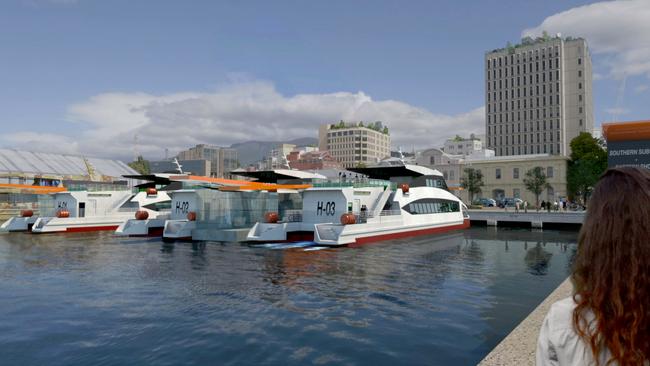
FERRY service with up to three routes between the CBD and Eastern Shore before expanding the ferry network with to up to eight terminals, each within a kilometre of key cycleways and
footpaths, stretching north and south of the city.
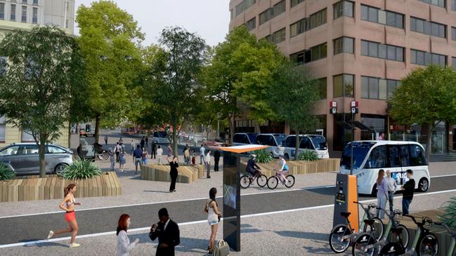
HI-TECH technology such as self-driving cars and smart-city options that allow traffic signals to communicate with vehicles to ensure smooth traffic flows.
MORE ON RACT’S HOBART MOBILITY VISION:
HAVE YOUR SAY ON HOBART’S TRAFFIC FUTURE
EDITORIAL: LOOK BEYOND THE HORIZON
IDEAS FLOATED TO EASE CITY CONGESTION
RACT executive general manager Stacey Pennicott said the club’s staged approach mapped out changes across infrastructure, public and active transport, urban planning, social and community issues, as well as future mobility and emerging technology.
“The first two stages focus on shifting people’s behaviours and patterns to embrace new
technology and mobility options,” she said.
“Hobart’s mobility network cannot improve without behaviour change.
“This takes time, real alternatives and a willingness to change.”

MORE OF TODAY’S NEWS
ASSANGE KICKED OUT OF EMBASSY, ARRESTED
RETIRING MLC JIM WILKINSON PRAISED FOR WISDOM AND INTEGRITY
NORTH AND NORTH-WEST TIPPED AS KEY ELECTION BATTLEGROUNDS
WOMAN JAILED FOR ROLE IN BODY PARTS MURDER
HAMMER KILLER COLLECTED DISABILITY SUPPORT PAYMENTS OF VICTIM
BREAKDOWN OF 30-YEAR STRATEGY
Years 1-5
Indicative cost: $64 million
Focus on “quick wins” for mobility, making public and active transport more affordable and
usable, improving land use planning and analysing access options for major infrastructure
projects.
Years 6-10
Build on the first five years, continuing to strengthen public transport and support multiple
occupancy modes of transport, as well as separating active transport modes from vehicles. Business case(s) would also be developed for major infrastructure project(s).
Indicative cost: $31 million
Years 11-20
Separated into two streams, dependent on whether the 20% mode share is achieved in the first 10 years or whether major infrastructure project(s) are required. This stage would also include the integration of low/zero emission transport options.
Indicative cost with major infrastructure: $1.5 billion
Indicative cost without major infrastructure: $214 million
Years 21-30
Focus on emerging technology such as autonomous vehicles and smart-city options including vehicle communication with traffic signals to ensure smooth flow.
Indicative cost $26 million

‘Roads are unsafe’: Councillor struck by car in scary city incident
A Hobart councillor has spoken of a frightening experience where he was struck by a car while jogging in the city recently, as he pushes for further pedestrian safety upgrades across the capital.

Lucky Tasmanian quickly retires after $900k lottery windfall
After learning they had won more than $900,000 on a winning TattsLotto entry over the weekend, a Tasmanian resident has quit their job and is now busily considering new life opportunities.