
400mm drenching: Weather model predicts wild weekend for SEQ
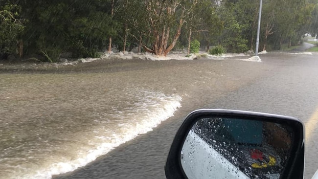
Torrential rain smashing large parts of the state overnight – with 243mm falling in a matter of hours in one place – leading to a dramatic rescue, as a low-pressure system was set to form to deliver a dangerous weekend-long drenching.
QLD News
Don't miss out on the headlines from QLD News. Followed categories will be added to My News.
Torrential rain is smashing large parts of the state – with 243mm falling at Coops Corner on the Noosa River, and 211mm at Tin Can Bay overnight – with life-threatening flash flooding and a swift water rescue adding to the drama ahead of a dangerous weekend-long drenching.
SCROLL DOWN FOR THE LATEST STORM WARNINGS AND FLOOD WATCHES
“The system is expected to drift gradually to the south, and it may affect South East Queensland later on Saturday or during Sunday, though there is still a large amount of uncertainty in the forecast position and track of this system,” the Buream warned on Friday.
“Heavy rainfall, which may lead to flash flooding, is forecast for areas east of Seventeen Seventy, Biggenden, Jimna and Maroochydore.”
Police are responding to reports of heavy rainfall and flash flooding near the Bruce Highway at Gympie. Police are also directing cars away from floodwaters on Rainbow Beach Road at Cooloola. Please follow police directions and remember #IfItsFloodedForGetIt. pic.twitter.com/VPLbTnmhXE
— Queensland Police (@QldPolice) October 21, 2022
Six-hourly rainfall totals between 100mm and 160mm were likely to continue, potentially becoming more extensive later on Saturday, with 24-hourly rainfall totals between 200mm and 300mm possible.
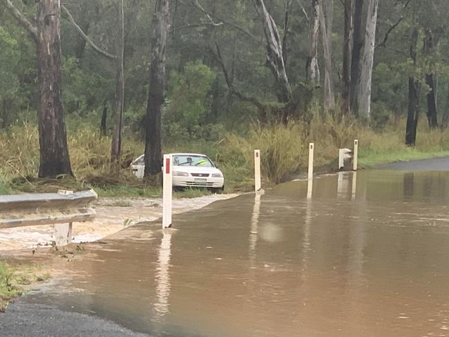
Emergency services on Friday rescued the occupant of a car after it went off a causeway into floodwaters in the Gympie region.
It was reported a person was trapped inside the car which went off the causeway near the Bauple Drive-Bruce Higjhway exit, with multiple fire crews in attendance, a Queensland Fire and Emergency Services spokesperson said.
The wet and wild weather caused congestion around Brisbane, with northside motorists heading north on the Gateway Motorway facing 55-minute delays.
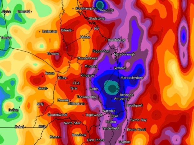
Up to 400mm could drench South East Queensland this weekend, bringing the risk of major widespread flooding, according to the latest weather models.
The European weather model known as the ECMWF has predicted a system along the coast that will bring heavy rainfall ranging between 300mm and 400mm over two days.
Another main weather model, GFS, has predicted the region will see lower tops of around 120mm fall in the South East region but experts can’t say yet which model is more accurate.
According to the ECMWF model, Brisbane will see more than 200mm on Saturday and Sunday, Caboolture more than 250mm, Sunshine Coast more than 250mm, Gold Coast more than 190mm and Toowoomba more than 130mm.
Helen Reid from the Bureau of Meteorology said almost the entire South East region would see a continuation of thunderstorms.
“We’re looking at a wet weekend with thunderstorms on the cards into next week,” she said.
“In terms of how much rainfall, that depends on where you’re located under the storms. But overall it’s not looking very good. They’re also keeping a close eye on what the rivers are looking like.”
Gold Coast City was placed on high alert from Friday morning, with Mayor Tom Tate saying it was “all hands on deck”.
Heavy rainfall was expected in the area over the weekend with the potential for flash flooding, while hazardous surf conditions are also expected.
“We’re on top of it but mother nature is unpredictable,” Mr Tate said.
Sandbagging locations are also open now at Pimpama, Bilinga and Burleigh.
Brisbane Lord Mayor Adrian Schrinner said Brisbane City Council stood ready to activate evacuation and community centres across the city if required.
Currently, more than 126,000 prepacked sandbags are ready for collection at Brisbane depots in Dara, Lota, Morningside, Newmarket and Zillmere.
“We have also distributed more than 55,000 bags since staging our three super sandbag weekends,” Mr Schrinner said.
“Our new flood mapping is free and available so residents can learn the risks related to their property.”
With a large amount of moisture in the air and troughs lurking off the coast, Ms Reid said authorities were now just waiting to see when flood warnings would need to be sent out.
Some councils have already started preparations with Brisbane City Council and Moreton Bay Regional Council offering up 24/7 sandbagging stations for all residents.
David Taylor from Brisbane Weather said on Friday the next 24 hours would be crucial in monitoring the developments of each weather model.
“If the EC model is correct, we know that it is going to create significant flooding around many parts of South East Queensland because it’s already waterlogged,” he said.
CURRENT STORM WARNINGS
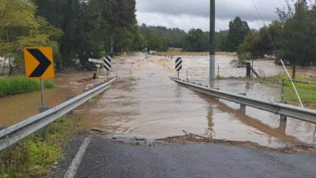
Gympie, Fraser Coast and Noosa Regional Councils on Friday issued emergency alerts warning residents of life-threatening flash flooding.
They warned over the next 36-48 hours intense rainfall totals of up to 200mm were possible.
Seqwater advised gated releases from Wivenhoe Dam have increased in response to the current weather conditions.
Minor gated releases from Wivenhoe Dam started on Saturday, October 15 to drain down water within the dam and provide additional flood mitigation storage for the 2022-23 summer season.
These releases, combined with runoff from downstream catchment flows, resulted in temporary closure of Colleges Crossing from Friday evening.
Twin Bridges and Savages Crossing remain closed until further notice due to dam releases.
There is a warning in place for severe thunderstorms that are likely to produce heavy rainfall that may lead to flash flooding for people in parts of the northern Darling Downs and Granite Belt and parts of Central Highlands and Coalfields, Capricornia, Wide Bay and Burnett and Maranoa and Warrego forecast districts.
Locations that may be affected include Roma, St George, Biloela, Goondiwindi, Mungindi and Tara.
By 6pm, intense rainfall in the warning area around Gympie and Noosa had temporarily eased. However, the redevelopment of intense rainfall remains likely, the Bureau warns.
The situation is being closely monitored and further detailed warnings will be issued as necessary.
South-West Queensland’s dam operator has advised outflows from Beardmore Dam are occurring at a rate of 11,000 ML a day.
Sunwater advised all persons in the Balonne Shire who have pumps near the river to monitor its level and consider removal.
QUEENSLAND AREAS UNDER FLOOD WATCH
South East Queensland, Wide Bay and Burnett regions were under flood watch, according to the Bureau on Friday.
Minor to moderate flooding was flagged as possible from Saturday onwards with isolated moderate to major flooding possible during the weekend.
Already wet catchments will be likely to respond quickly to rainfall, according to the warning, with a small tidal anomaly of up to 20cm forecast for the weekend which could increase river and creek levels in tidal areas.
Another flood warning has been issued for the Mary River with minor flooding likely at Dagun Pocket tonight and at Gympie overnight into Saturday.
There is expected to be increased showers and thunderstorms over the weekend and the chance of heavy to intense rainfall over the South East region from Saturday night into Monday.
This means creek and river levels could rise rapidly and flash flooding is likely from Friday night.
Regional Harbour Masters have asked boaties to be alert of increased water flows in creeks and rivers with heavy rain and saturated catchments.
Catchments likely to be affected include:
Baffle Creek
Kolan River
Burnett River
Burrum and Cherwell rivers
Mary River
Noosa River
Sunshine Coast rivers and creeks
Pine and Caboolture rivers
Upper Brisbane River
Lower Brisbane River (creeks and tributaries only, flooding not expected in lower Brisbane River itself at this stage)
Logan and Albert rivers
Gold Coast rivers and creeks
Originally published as 400mm drenching: Weather model predicts wild weekend for SEQ

Driver trapped, lanes closed after motorway crash
A woman has been injured and the peak-hour commute thrown into chaos following a two-vehicle crash on the Ipswich Motorway.
Read more

Two shots heard before victim collapsed outside Hervey Bay unit
A young man is fighting for life after being shot possibly twice outside his grandmother’s unit in Hervey Bay, with neighbours reporting hearing gunfire near a school in the community’s second shooting in days.
Read more