Rivulet bursts banks as deluge smashes Tasmania’s south and alpine areas record snow
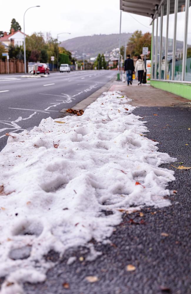
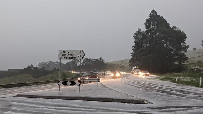
Some Tasmanians have woken to a winter wonderland after alpine areas recorded a dumping of 20cm of snow overnight. WARNINGS + FORECAST >>
News
Don't miss out on the headlines from News. Followed categories will be added to My News.
Latest updates on the severe weather conditions:
Ben Lomond received a 20cm dusting of snow overnight Friday - a month before the snow season proper opens.
“Snow is dumping down,” Ben Lomond Snow Sports said on Saturday morning.
“Conditions are still very wild up here so if you are visiting today be prepared . There are no facilities open on the mountain and snow chains are a must.”
Dane Liepins from Ben Lomond Snow Sports said the snow season would open on the June 11 long weekend.
“The early snow has got everyone excited about the season ahead,” Mr Liepins said.
“Hopefully it is a snowy winter. I came down from the mountain this morning and there were a number of vehicles heading up and the rangers were there to ensure everyone stayed safe.”
A new $2.1m public shelter is under construction on Ben Lomond to enhance the visitor experience and provide a modern entry point to the ski village.
“We are excited it is finally going ahead,” Ben Lomond Alpine Resort managing director Ben Mock said when the state government announced work was due to start.
“The pub burnt down in 2018 and since then the Parks and Wildlife Service had installed two shipping containers with heaters to allow people to wait for buses and other services.”
Rain will ease in Hobart on Sunday before fine conditions dominate on Monday, Tuesday and Wednesday. Showers will return on Thursday and Friday.
The low currently centred near the SE of #Tasmania will slowly move to the E during today. It will be mainly fine about the central N today with showers elsewhere. Those showers will generally be heavier about the SE and the far S. Stay safe and heed warnings. pic.twitter.com/u8briXNvJW
— Bureau of Meteorology, Tasmania (@BOM_Tas) May 6, 2022
The Tasmania State Emergency Service said it responded to close to 140 requests for storm damage assistance between Thursday and Friday night.
About 50 volunteers clocked up about 400 work hours.
Acting Deputy SES Director Nick Connolly said the worst of the weather appeared to be over, but Tasmanians should still exercise caution.
“We’re not expecting any more major issues but we are asking people to be mindful of increased river flows as the rain continues,” he said.
“People should stay away from affected creeks and rivers and be aware of potential debris on roads and in other areas.”
‘Volatile situation’: Hobart records biggest rainfall in four years
5pm, Friday May 6
TASMANIANS have been warned to brace for more wild weather amid a “volatile situation” which has already seen heavy rainfall and widespread flooding across the South.
The Bureau of Meteorology called for people to remain vigilant while a low pressure system continues to linger over the region.
BOM senior meteorologist Simon Louis said the severe weather warning would remain in place and had been extended to parts of the Northeast.
“With the low moving around we’re expecting damaging winds may develop in the Northeast on Friday night,” Mr Louis said.

“We’re expecting quite a windy and showery wet day tomorrow for Hobart and the lower East Coast – there is some risk that if that low behaves a bit differently or intensifies a bit more than expected, we could see damaging winds develop there as well.”
It comes after homes were flooded and battered by heavy rainfall and thunderstorms across the South in the early hours on Friday.
Clarence and Glenorchy lay right in the path of the thunderstorms and were the areas hardest hit, according to SES acting director Leon Smith.
Mr Smith said emergency services had received more than 250 calls for assistance Friday morning and responded to 128 separate incidents, the majority for homes inundated due to overflowing stormwater drains and gutters.
The SES operations building itself was struck by lightning, experiencing a brief power outage along with surrounding businesses on Bathurst and Argyle St.
The outage did not affect the service’s ability to respond to calls, Mr Smith said.
“After 4am this morning, we thought we’d actually dodged a bit of a bullet to tell you the truth, before the thunderstorms hit,” he said.

“A lot of people actually slept through the night only to wake this morning and find their homes inundated.”
kunanyi/Mt Wellington copped the most rainfall for the night, recording 124mm, while Nugent had 120mm, Leslie Vale recorded 108mm and South Hobart 106mm.
St Aloysius Catholic College in Kingston and Sacred Heart Catholic School in Geeveston were forced to close for the day, impacting over 1300 students, while damage suffered at MacKillop Catholic College in Mornington meant the school would be shut until next week.
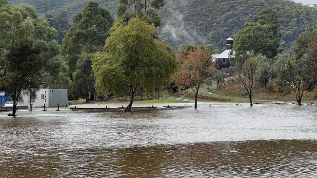
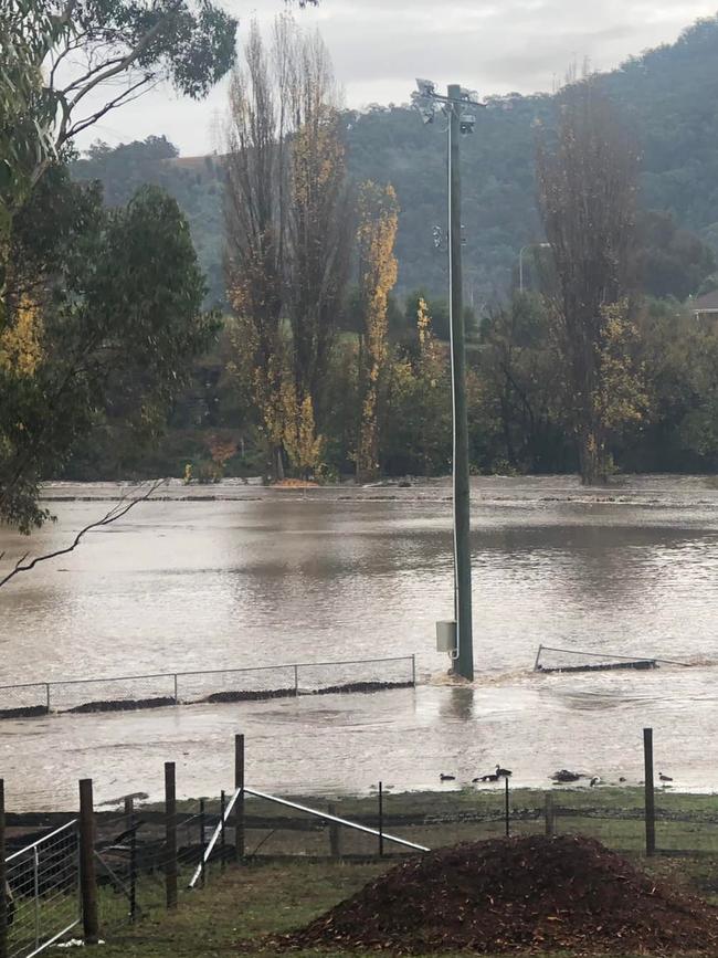
Tynwald Park in New Norfolk resembled a swimming pool with goalposts on Friday morning, as Derwent Valley mayor Michelle Dracoulis warned the ground would be closed for at least a week, affecting the junior football club.
“We need to address the debris and health and safety issues around the access, gravel and playing surfaces,” Ms Dracoulis said.
“We’ll work hard to minimise the impact on the community.”
Flood alerts remained late Friday for the Huon, Macquarie, Jordan and South Esk rivers, while a minor warning was also in place for rivers fed by the Lower Derwent.
Rainfall of up to 25mm was expected for the Hobart region and Huonville on Saturday, with river levels anticipated to keep rising throughout the day.
Southern District Police Commander Tim Dooley said motorists had taken heed of all warnings so far but needed to continue to exercise great caution.
“Please leave early and allow additional time to travel if driving, and leave extra distance between vehicles,” Mr Dooley said.
Hundreds of insurance claims to roll in as schools flood
1pm Friday, May 6
Hobart has recorded it’s sixth highest rainfall in 120 years as RACT prepares for a significant increase in insurance claims following wild weather overnight.
RACT Group CEO Mark Mugnaioni said they have already received an influx of calls regarding water damage to homes, overflowing gutters and wind damage to roofs.
“If we take our historical experience of claims, we can expect somewhere up to 300 households to lodge over the next few weeks,” said Mr Mugnaioni.
“The sooner customers lodge their claims, the sooner we can go about assessing and fixing the damage caused by the conditions.
“As Tasmania’s only local insurer, our storm recovery efforts are in full swing with our assessors and claims staff on the ground helping with emergency make safes, cleaning up and drying out homes that have been impacted.
A total of 14 schools in southern Tasmania have closed for the day due to the wild weather with MacKillop Catholic College at Mornington suffering some damage.

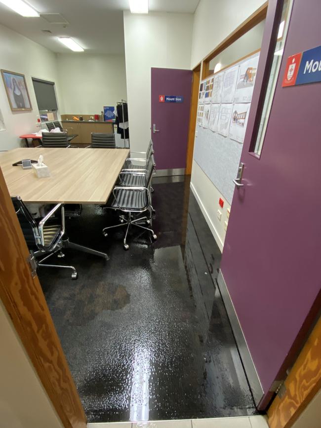
“Unfortunately, MacKillop Catholic College at Mornington has suffered some damage due to the rains and while the small amount of students in attendance were being supervised, the school will not be operational until next week.” said Executive Director of Catholic Education Tasmania, Dr Gerard Gaskin.
“A number of Hobart region schools of Catholic Education Tasmania have encouraged students to stay at home for today if possible.”
Although rainfall has eased in southern Tasmania a severe weather warning remains current with heavy rainfall possible to continue around the far south into the afternoon.
Minor to moderate flooding is likely to develop in rivers in a matter of hours with local creeks and small rivers also rapidly rising.
This includes east coastal rivers (south of Bicheno), and creeks flowing down from Mt Wellington (such as Humphreys, Hobart, North West Bay, and Browns rivulets and Mountain River) and the Wellington Ranges (such as Styx and Plenty rivers).
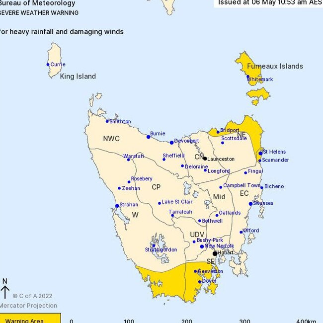
The following warnings are current:
- A Moderate Flood Warning is current for the Jordan River.
- Minor Flood Warnings are current for Huon, Derwent, South Esk, and Macquarie. Flooding is also expected along the Coal River.
- Additional areas of localised flooding may develop during Friday with further heavy rainfall and thunderstorms, particularly in southern parts covered by the Severe Weather Warning.
Footy fields turn to swimming pools
11:00am Friday, May 6
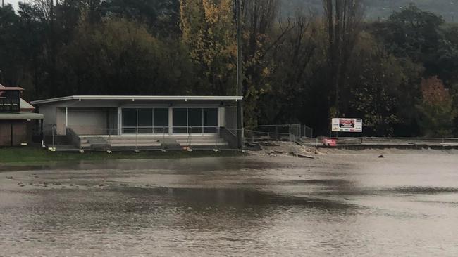
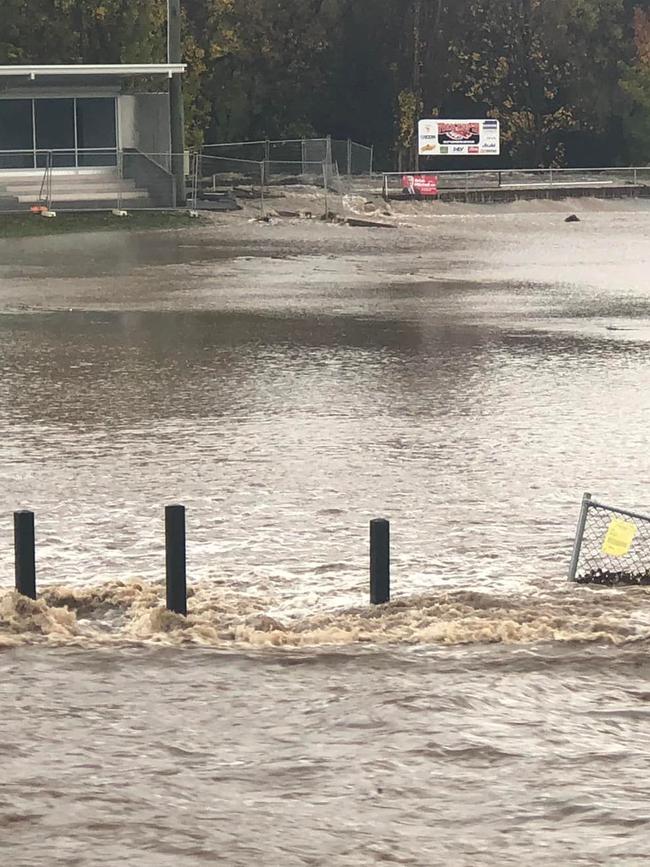
Tynwald Park in New Norfolk has been washed out as heavy rain turned the football field into a swimming pool.
“The last time we were flooded we were unable to use the oval for four weeks, this is worse.” posted New Norfolk Junior Football Club to Facebook.
There are currently 11 power outages affecting 2482 customers across the south of the state with TasNetworks attending a pole fire in Montagu Bay following multiple reports of fallen trees and powerlines.
A severe weather warning remains current for parts of Tasmania’s Western, South East, North East and East Coast districts with heavy rainfall expected to ease during over the day.
Rainfall totals in parts of the south cracked over 100mm in 24 hours, with Mt Wellington recording 124mm, South Hobart recording 106mm and Hobart CBD recording 85mm.
School closures:
- Blackmans Bay Primary School
- Glenorchy Primary School
- Huonville Primary School
- Kingston Primary School
- Montagu Bay Primary School
- South Hobart Primary School
- Waimea Heights Primary School
- Huonville High School
- Kingston High School
- New Norfolk High School
- Rose Bay High School
- St Aloysius Catholic College
- Sacred Heart Catholic School
- MacKillop Catholic College
Road closures:
- Bay Road, New Town.
- Enfield Lane, Campania, open to 4WDs and Trucks only.
- Ford Road, Pontville
Hazardous Roads
- Back Tea Tree Road, Richmond, 1km from Grass Tree Hill Road.
- Brooker Highway, Granton.
- Charlotte Street, Huonville.
- Glen Huon Road, Huonville near the Huonville Bridge.
- Glenluck Road, Berriedale (rocks on the road).
- Huon Highway, Grove near Willie Smith’s.
- Huon Highway, Glendevie. Surface water on road, passable with caution.
- Lyell Highway Granton.
- Main Road, Moonah near Springfield Avenue.
- Marguerite Street, Ranelagh.
- Mary’s Hope Road, Rosetta.
- Mill Road, Collinsvale.
- Pass Road, Rokeby.
- Risdon Road, New Town.
- Rosny Hill Road, Rosny near Eastlands Shopping Centre.
- Sally Peak Road, Buckland.
- Tasman Highway between Orford and Runnymede.
- Tasman Highway, Rose Bay – Slip Lane Underpass.
- Tea Tree Road, Tea Tree, 1km East of the train tracks.
- Tottenham Road, Gagebrook.
High rainfall totals so far …
- 124mm Mount Wellington
- 106mm South Hobart
- 108mm Leslie Vale
- 85mm Hobart CBD
- 79mm Hobart Airport
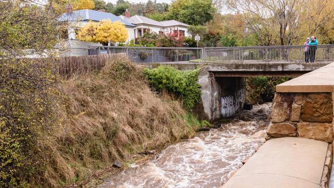
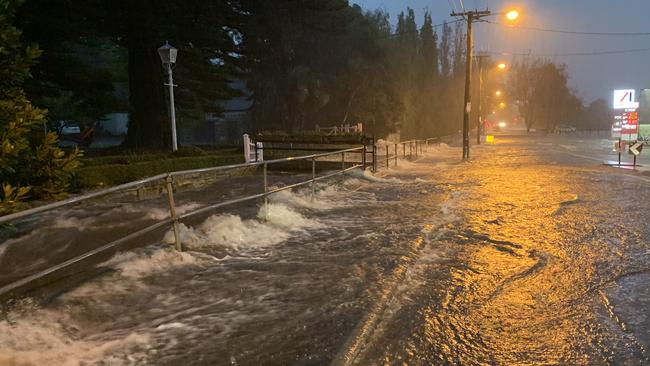
Rivulet bursts its banks and cars become stuck in floodwaters
A rivulet has burst its banks, and a number of Hobart schools have closed for the day, as authorities warn more “intense rainfall” is on the way.
Radio stations across the city were down for at least two hours due to the severe weather conditions and multiple cars have become stuck in floodwaters at Rosny.
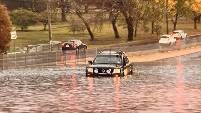
“Police advise motorists to avoid Risdon Road, Hobart between the Ampol Service station and the Brooker Highway due to flooding,” a police statement said.
âš ï¸Minor #Flood Warning current for #Huon River. Up to 40 mm of rainfall recorded since 9 am Thursday. Moderate flooding is possible if widespread heavy rainfall continues. See https://t.co/V9LYfDAYDq for details and updates; follow advice from @SESTasmania. #TasFloodspic.twitter.com/y5rfUq2QF2
— Bureau of Meteorology, Tasmania (@BOM_Tas) May 5, 2022
“The rivulet has broken it’s banks. The road will be closed until further notice.”

The Bureau of Meteorology warns heavy rainfall and damaging south-easterly wind gusts will impact eastern and southern Tasmania.
“Heavy rainfall which may lead to flash flooding is forecast for the southeastern half of Tasmania, including the South East and Upper Derwent Valley districts, and parts of the East Coast, Midlands, Central Plateau and Western districts,” a BOM statement said.
“Six-hourly rainfall totals between 40 to 60mm are likely.
“Heavy rainfall is expected to contract south and west of Hobart by Friday afternoon and then ease during Friday evening.

Locally intense rainfall which may lead to dangerous and life-threatening flash flooding is also possible with very heavy showers and thunderstorms over parts of the East Coast and South East districts during this period, with six-hourly rainfall totals of 80 to 100mm.
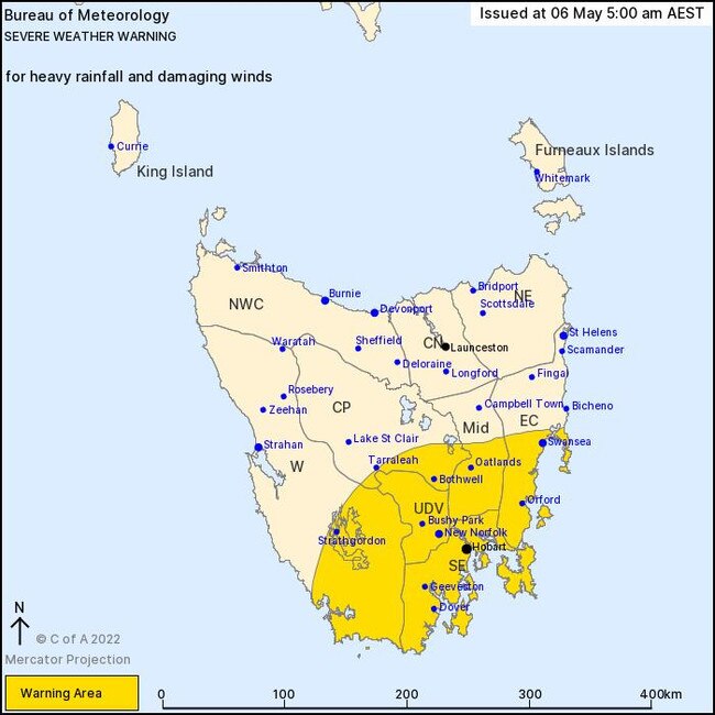
Locations which may be affected include Orford, New Norfolk, Dodges Ferry and Bagdad.
The SES expects the most dangerous weather to occur this morning, easing over the afternoon.
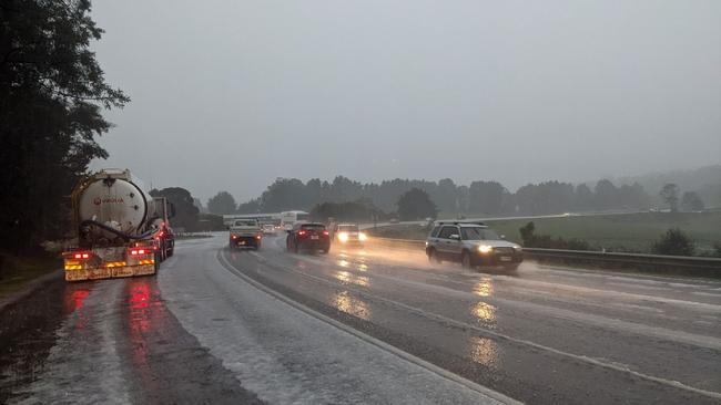
The weather event has also forces the closure of at least one school in the Hobart region.
Rose Bay High School alerted parents and students on Social media that it would be closed due to water damage.
“ATTENTION – Our school is closed today as a consequence of water damage,” it said.
Students of MacKillop Catholic College are also asked to stay home today due to flooding at the College.
“We would like to encourage our families to keep their children at home,” it said
“If you have no alternative, there will be staff at the College to supervise your children today.”
SES Acting Director Leon Smith said crews had attended roughly 30 calls for assistance overnight, including 15 due to water inundation.
“There continues to be a particular risk of moderate flooding in the Huon River, however other areas should not be complacent,” he said.
“SES crews and local police have been out door knocking residents, businesses, and caravan parks in the Huon area overnight to ensure they are prepared in the event of major flooding of the Huon River.
“All residents in the Huon Valley and other flood prone areas are urged to remain vigilant and keep up to date by checking the BOM and SES websites.
“With thunderstorm activity currently being experienced in the greater Hobart area we may also expect flash flooding, so people are advised to remain alert.”
SEVERE WARNING: Tassie braces for rain, wind, snow and floods
Thursday, May 5
The SES is urging Tasmanians to prepare for heavy rains and flooding as a severe weather system passes through the south east of the state tonight.
Heavy rainfall and damaging winds are expected to hit the Huon Valley, greater Hobart and parts of the East Coast with the most dangerous weather forecast for the early hours of Friday.
Low pressure to intensify and move over #Tas Friday, bringing rainfall totals of 50-100mm in parts of the lower east and through the south. Heaviest rainfall to be overnight. Southeasterly wind gusts of 80-100kmh developing late tonight and early Friday. https://t.co/8cvZh1myxcpic.twitter.com/7Ioj7XXDuj
— Bureau of Meteorology, Tasmania (@BOM_Tas) May 5, 2022
SES Acting Director Leon Smith said the community would feel the impact of the rain.
“We know there is a particular risk of moderate to major flooding in the Huon Valley, but other areas should not be complacent,” Mr Smith said.
“With potential thunderstorm activity, we can also expect flash flooding, but we can’t predict exactly where this may occur.”
“We’re anticipating we may start to receive calls for assistance in the early hours of Friday morning, based on the forecast.”
Current warnings
Sheep Graziers – Furneaux Islands, Midlands, East Coast, Upper Derwent Valley and South East forecast districts
Severe weather warning – Upper Derwent Valley, South East, East Coast and parts of Western, Central Plateau and Midlands Forecast Districts.
Flooding
Macquarie River
Coal River
Huon River (minor)
Jordan River (minor)
Flood watch
South East
Huon
Derwent
North and North East
Moist and vigorous airstream to bring dangerous weathing
Thursday, May 5: A “very moist and vigorous” south-easterly airstream will build across eastern and southern Tasmania today is expected to bring damaging winds, heavy rainfall and possible flooding, the Bureau of Meteorology warns.
According to forecasters, a severe weather warning issued this morning will likely continue through Friday and early Saturday.
Warning include Strong south-easterly winds averaging around 50 km/h with damaging gusts of around 80 km/h possible over eastern and southern.
Heavy rainfall and possible flooding is forecast for the south eastern half of Tasmania from late Friday.
âš ï¸ Severe Weather Warning issued for damaging #winds & heavy #rain for Eastern and Southern #Tasmania from late Thursday. See https://t.co/V9LYfDAYDq for details and updates; follow advice from @SESTasmania. #TasStormspic.twitter.com/ltBHCIMMP8
— Bureau of Meteorology, Tasmania (@BOM_Tas) May 4, 2022
Areas on flood watch include including the East Coast, South East and Upper Derwent Valley districts, and parts of the North East, Midlands, Central Plateau and Western districts.
“Six-hourly rainfall totals between 40 to 60mm are likely, with higher totals possible in elevated areas and with thunderstorms,” the BOM warns.
Rainfall is expected to ease over Saturday.
Locations which may be affected by wind rain and potential flooding include St Helens, Swansea, Bicheno, Orford, New Norfolk, Bothwell, Hobart, Geeveston and Dover.
âš ï¸ Severe Weather Warning issued for damaging #winds & heavy #rain for Eastern and Southern #Tasmania from late Thursday. See https://t.co/V9LYfDAYDq for details and updates; follow advice from @SESTasmania. #TasStormspic.twitter.com/ltBHCIMMP8
— Bureau of Meteorology, Tasmania (@BOM_Tas) May 4, 2022
‘Dangerous’ storms, flash flooding and heavy snow to hit Tasmania
TASMANIANS may need to change their Mother’s Day weekend plans, the SES warns, with intense rainfall and potentially damaging winds forecast until Sunday.
The Bureau of Meteorology predicts the most severe weather will occur Friday, with rainfall of up to 100mm expected for parts of the state’s South and East.
The looming low pressure system could also bring heavy snowfall across the Central Highlands and damaging winds of about 100 km/h in coastal areas, senior meteorologist Simon Lewis said.
âš ï¸ Severe Weather Warning issued for damaging #winds & heavy #rain for Eastern and Southern #Tasmania from late Thursday. See https://t.co/V9LYfDAYDq for details and updates; follow advice from @SESTasmania. #TasStormspic.twitter.com/ltBHCIMMP8
— Bureau of Meteorology, Tasmania (@BOM_Tas) May 4, 2022
The mercury will drop to as low as 7C in Hobart on Thursday, with snow falling above 1000m on kunanyi/Mt Wellington.
Sunday will see a medium chance of showers and winds easing off in the afternoon with a maximum temperature of 15C.
“There’s a risk of significant flash flooding and riverine flooding across the South and East,” Mr Lewis said.
“(The weather system) is an East Coast low, which is going to develop on Thursday and hang around until Saturday.”
Mr Lewis said there was still uncertainty around the BOM’s modelling of the weather system and warned people to remain informed.
“It’s a dynamic situation, it is important people stay up to date with the latest warnings and forecasts,” he said.
“For the most part over summer we haven’t had a lot of heavy rain and people will not have seen some of these falls recently … this could develop into a high-end event fairly quickly.
“Probably the main areas of concern are the Huon Valley and the Hobart region, around Glenorchy and Kingston.”
A cold front crossing #Tasmania on Wed will see the start of a cool and wet period across the state. An area of low pressure will dominate from Thurs to Sat, with the location and strength of low centres difficult to pin down. Check your forecast at https://t.co/5mL3LaC8ps . pic.twitter.com/vFmwGVYTsQ
— Bureau of Meteorology, Tasmania (@BOM_Tas) May 3, 2022
Tasmania SES acting director Leon Smith said people considering travel over the weekend should heed the slogan “if it’s flooded, forget it”.
“Don’t enter flood waters under any circumstance, it’s extremely dangerous,” he said.
Mr Smith also told drivers to be mindful of debris on the road and potential large obstacles like fallen trees.
He said adapting usual driving habits to suit the conditions would be the key to safety on the roads this weekend.
“If the wind speeds we anticipate eventuate, along with the wet soil and rainfall, there’s great potential for trees to come down – it’s a threat to people outdoors.
“It’s essential you make other motorists aware of your presence on the road – turn your headlights on during daytime hours and monitor your speed proportionate to the situation.”
He urged Tasmanians to “remain vigilant” and to regularly check the SES website for updates.
“We don’t know exactly how the weather conditions will eventuate, which is why it’s so important that people closely monitor the forecast and warnings.”
SES advises people in these areas to do the following to prepare:
- Check bom.gov.au for the latest weather forecast and warnings
- Check that family and neighbours, especially those who are vulnerable, are aware of warnings and have a plan in place
- Be prepared for flash flooding
- Clear drains and gutters of debris so they flow freely
- Tie down loose items such as outdoor furniture and play equipment
- Have a plan for managing pets and livestock
- Be prepared for power outages
In the event of heavy rainfall:
- Supervise children closely
- Manage pets and livestock
- Never enter or drive through floodwaters, and when driving lookout for debris on roads including fallen trees and power lines
- Report power outages to TasNetworks on 132 004
- Listen to ABC radio or check www.ses.tas.gov.au for further advice
- Call SES on 132 500 for flood and storm-related emergency assistance
- Dial triple-0 (000) in a life-threatening emergency
Chaotic cold front could bring wild weather
Tasmanians have been warned to brace for heavy rain as a cold front begins to slowly move across the state on Wednesday.
As much as 75mm of rain could fall in Hobart between now and Saturday, with snow falls tipped on the west coast to an altitude of around 1000m and later in the week for kunanyi/Mt Wellington.
Bureau of Meteorology forecaster Tristan Oakley said rain could be expected statewide through Wednesday morning.
“There may also be a few showers in the afternoon – the coldest air will be quite late in the day, and early Thursday morning there could be some snow in the south, maybe up to 25mm around kunanyi,” he said.

Mixed farmer Sarah Jacobson said the forecast rain would be very welcome at her Copping property after a relatively dry last few months.
“We haven’t really had any rain for probably about five weeks now,” Ms Jacobson said.
“It would be nice if we get what is forecast for this week – if the (60mm) is spread out across three days or so that’s great – you don’t want too much too quickly because it will just run off instead of soaking in.”
Ms Jacobson said rain at this time of year was always a shot in the arm for farms heading into winter.
“Pretty much everything will benefit from it, especially while we’re still getting the warm and sunny days – if we get a good rain, that will boost our feed going into winter.”
While a strong low pressure system is forming off the east coast, Mr Oakley said there was still uncertainty as to how long the weather would linger.
“It all depends on where this low pressure system is going to end up over the coming days,” he said.
“Some of our modelling has it staying around the east and southeast of the state, some models have it moving away from the state completely.
It might mean there isn’t much rainfall at all, but if it moves further west we’ll see a fair bit, especially in the south.”
The wildest conditions are tipped for Friday, when up to 50mm of rain is forecast for parts of the south and southeast.


