
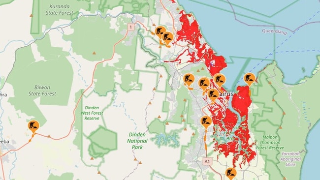
Large swathes of Cairns ‘under threat’ from 3.5m storm surge
Ergon Energy has explained how it considers early power cuts for storm surge zones, as a king tide coupled with heavy rain is expected to inundate large areas - red and orange zones - of Cairns.
Cairns
Don't miss out on the headlines from Cairns. Followed categories will be added to My News.
A storm surge of half a metre above a king tide of 3m is expected to inundate large swathes of Cairns which will combine heavy rain to place homes and infrastructure “under threat”.
King tides will be experienced in Cairns from Tuesday December 12, through to Sunday December 17 and a peak tide of 2.99m is expected on Thursday at 10.10am.
Tuesday’s peak will reach 2.98m at 9.27am.
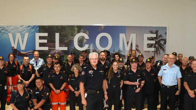
Far Northern Region Assistant Commissioner Brad Commens warned of the threat from the Cairns Airport on Tuesday where he welcomed the arrival of about 70 SES volunteers who have been deployed in response to Cyclone Jasper.
“At the moment the latest predictions are that the storm surge could be up to half a metre above the highest astronomical tide,” he said.
“It could mean inundation of large areas, particularly the low lying areas of Cairns, even the airport approaches and things like that may be under threat, so I’m advised that the airport will close tonight at 10pm for the last flight in.
“The storm surge and the king tide that will come, will converge to cause a higher than normal tide around the central CBD, North Cairns, Portsmith and along the northern beaches are the highest risk areas.”
A storm surge prepare to leave warning was issued by Cairns Regional Council at 9.30am on Tuesday.
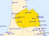
Residents in red and orange zones, which includes large areas of the city, Portsmith, most of the coastal northern beaches suburbs, Parramatta Park, Bungalow, and Manunda have been told to be ready to leave their homes.
Some Cairns councillors have issued statements on social media and radio that Ergon Energy was going to cut power to homes in red and orange zones on Tuesday afternoon.
An Ergon spokeswoman said localised power cuts would be considered as the situation developed but a blanket power cut to all homes in red and orange zones had not been planned.
“We will continue to monitor weather conditions and if we need to proactively de-energise any sections of the network for public safety we will, but that will depend on the impacts at the time,” the spokeswoman said.
“If critical assets are at risk of flooding … we can circumvent further damage by turning them off. These decisions are made on a case-by-case basis.”
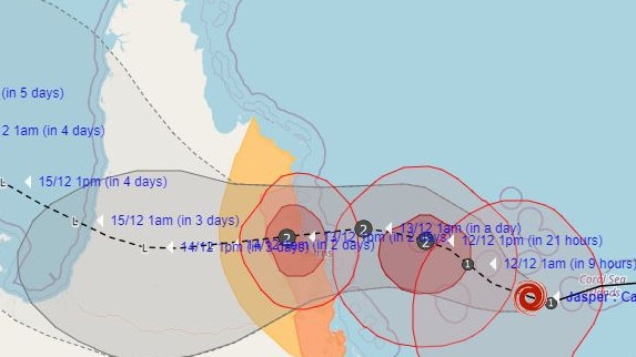
#CycloneJasper is steadily strengthening this morning east of Cape York Peninsula, Australia 🇦🇺🌀
— Zoom Earth (@zoom_earth) December 11, 2023
Jasper is currently forecast to become a Category 2 Tropical Cyclone (on the Australian scale) and make landfall between Cooktown and Cairns on Wednesday afternoon. pic.twitter.com/fpfIQdOKZT
Storm surge is when coastal waters rise above highest tide levels because of a cyclone.
According to council “tsunami-like waves” can go a long way inland and storm surge is a “threat to life and property”.
If you don’t have a safe place to go, public storm tide cyclone shelters will be opened at 10.30am on Tuesday.
Shelters out of the storm surge zone at 10-20 Walker Rd Edmonton and Redlynch State College on Jungara Rd are open now.
The Global Forecast System weather model has predicted a five day rain accumulation total of 497mm for Cairns, while other models have forecast a more conservative five day total of about 250mm. While in Port Douglas rain accumulation could range between 600mm and 300mm during the next five days.
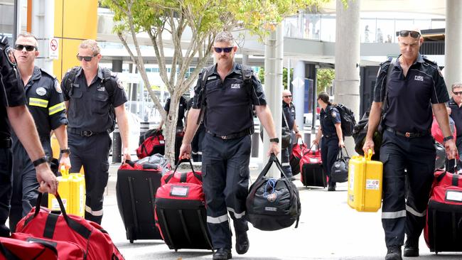
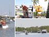
Asst Comm Commens said Queensland Fire and Emergency Services Disaster Assistance Response Teams are now on the ground and alongside SES crew personnel they will assist with rescues, securing properties, tarping roofs, clearing fallen trees and offering help to evacuees in emergency shelters.
Teams will be dispersed between Cairns and Port Douglas.
“Their main focus after the cyclone goes through, will be first of all rescue of course, and swift water rescues are always a challenge in this type of environment,” he said.
“There will be tree damage, there could be trees across roads, our SES staff are well trained to manage that, to cut the trees to reopen access to communities.”
The fresh SES crews add to a 12 specialist rescue teams that arrived in Cairns on Monday.
At 10.55am the latest Bureau of Meteorology update had Cyclone Jasper crossing the coast at the Indigenous community of Wujal Wujal as a category 2 system soon after 10am on Wednesday.
More Coverage
Originally published as Large swathes of Cairns ‘under threat’ from 3.5m storm surge
Join the conversation

‘Wanton lawlessness’: Teen carjacker caught after his second victim in a day got away
An 18-year-old who violently carjacked one man experiencing car troubles in Manunda, then tried the same crime with a knife on a 19-year-old woman returning home from work late at night, has been sentenced in Cairns District Court on three charges.
Read more
Health workers visit remote island following malaria outbreak
Health authorities are warning residents on a remote island in the Torres Strait to undertake “mosquito control measures” after a second case of locally acquired malaria was detected recently.
Read more