
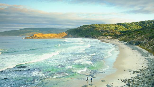
Tasmania is known for its spectacular shorelines. Freycinet is the state’s most visited national park and a key tourism site, attracting about 300,000 people a year before COVID-19 struck.
Images of Wineglass Bay at Freycinet and the Bay of Fires further north are virtually synonymous with Tasmania’s tourism brand.
But for many locals and visitors who would rather disappear into nature than show their botties at a Dark Mofo Winter Solstice Nude Swim at Sandy Bay, the state’s coastline is best experienced beyond the aspirational beaches.
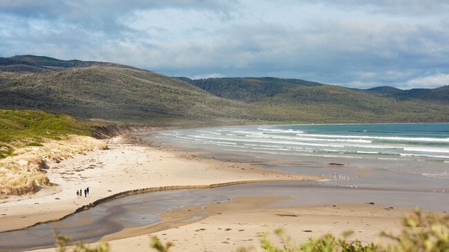
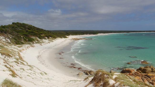
You would be one of many hikers on any given day to walk into Wineglass Bay, but you could well be the only person on the huge sweep of sand and red rock that is Friendly Beaches, just half an hour’s drive from the Wineglass Bay Walk carpark.
Picture: STUART GIBSON
Some wonderful sandy beaches are more off the beaten track. Such wonders include South Cape Bay, a four-hour walk from Cockle Creek along the famed South Coast Track in southern Tasmania; Hopground Beach on Maria Island; and Trousers Point Beach on Flinders Island. Others are well known to locals, such as Stumpys Bay in North-East Tasmania and Trousers Point Beach on Flinders Island.
There are also many rocky, cliff and surf beaches worth seeking out. The North West and South-East coast are good for surfing, including at Shipstern Bluff if you are a total crazy-brave able to ride giant waves
Wherever you drive near the coast and spot an unassuming little carpark, expect a beach beyond. And chances are it will be a beauty.
SOUTH
Eaglehawk Neck Beach
A one-hour drive east of Hobart on the Tasman Peninsula, the area is best known for its natural geological wonders, including the Tessellated Pavement and nearby Tasman Arch, blowhole and Devil’s Kitchen. The beach is on the eastern side of the isthmus, which connects the Tasman Peninsula to the Forestier Peninsula, and is a popular surfing spot and holiday destination for locals. The Lufra Hotel and cafe is a good place to sit and enjoy the view of the beach and Pirates Bay.
Mickeys Beach near Randalls Bay
About an hour’s drive from Hobart via Huonville and Cygnet, Mickeys is a sheltered bush beach popular with locals and families. Head to Randalls Bay, where there’s a barbecue and toilets, and continue on towards Eggs and Bacon Bay. Look for a small sign on the left, which marks the entrance to a bumpy dirt driveway that leads to a carpark above the beach. It’s a short walk from there to a protected, sandy beach with rock platforms at either end. There’s a nice 30-minute return walk around the headland to Randalls Bay.
Cloudy Bay Beach, Bruny Island
Cape Bruny and Cloudy Bay are at the far south of Bruny Island, near Cape Bruny Lighthouse – about an hour’s drive from the Bruny ferry terminal. It’s a popular surfing beach with two campgrounds (the Pines and Cloudy Corner; BYO water and firewood) and budget and luxury accommodation options nearby.
It’s great for long walks and fun in the sand dunes. There are more sheltered swimming options at nearby Cloudy Bay Lagoon and Jetty Beach.
South Cape Bay, Southwest National Park
It’s a four-hour return walk to this beautiful remote beach within the Southwest National Park. The walk starts from the end of Australia’s most southerly road at Cockle Creek and is at the eastern end of the popular seven-day South Coast Track to Port Davey. The walk takes in marshlands, forests and spectacular views of South Cape, Lion Rock and the turbulent ocean from hazardous cliff tops.
Dress warmly as it's next stop Antarctica. There are campgrounds and toilets inland near the creek leading to the beach. A parks pass is required.
NORTH AND EAST
Trousers Point Beach and Fotheringate Bay, Flinders Island
Yes, it’s a funny name, but it is a lovely beach. Trousers Point is a small jut of land on the west coast of Flinders Island with beaches either side of the point: Trousers Bay (Trousers Point Beach) and Fotheringate Bay.
Trousers Point Beach has spectacular views back to Mt Strzelecki as well as pristine white sands and crystal clear, calm water.
Fotheringate Bay Beach is known for its fascinating rock formations and granite caves. The fishing is excellent; if you cast a line, you are almost guaranteed to catch dinner. If you feel energetic, try walking to the 765m peak of Mt Strzelecki – on a clear day you can see the Tasmanian mainland.
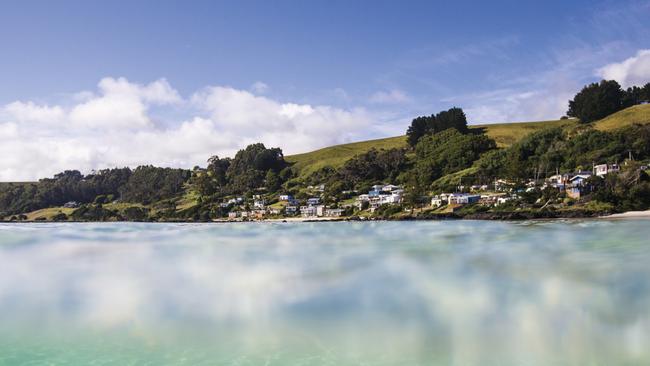
Binalong Bay
This is not exactly a secret location, but it’s a blissfully quiet beachside settlement well worth remembering. Situated at the southern end of the Bay of Fires on the East Coast, Binalong Bay is a 15-minute drive from St Helens, or about 2½ hours from Launceston.
Voted Lonely Planet’s hottest global holiday destination in 2008, it has been a favourite holiday spot for Tasmanians for much longer.
And in 2020, it retains its laid back charm.
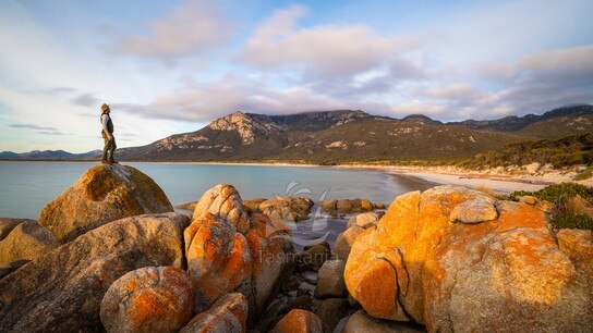
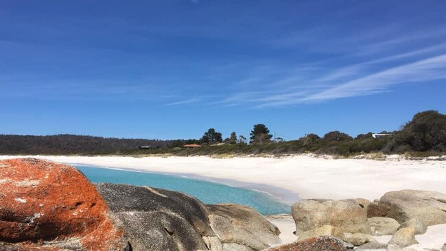
With its fine, white sand, stunning azure water and outcrops of massive granite boulders fringed with that iconic orange lichen, it is a beautiful place. As well as the main beach, there are numerous sheltered coves, gulches and inlets all the way along the Bay of Fires, so you are bound to find the perfect spot to stop and enjoy the scenery.
The town has plenty of services, including several eateries and accommodation options.
Stumpys Bay in Mt William National Park
Not far from the small town of Gladstone and Bay of Fires camping, Stumpys Bay beaches are popular with locals who will “set up a site and stay for weeks”, Fry says. “There are four separate camping grounds and it’s really beautiful.”
The area is known for its beach walks, fishing and diving; swimmers should take care. Eddystone Lighthouse is at the southern end of the national park. BYO firewood and water. A parks pass is required.
Beerbarrel Beach and Peron Dunes, St Helens
At the tip of St Helens Point, facing east to the sea, Beerbarrel Beach is a bit wild, a bit rugged and quite breathtaking.
You will need to walk down a track from the carpark to reach it, but the short trek through the scrub and dunes is worth it for the sense of awe and isolation when you reach the beach.
As it points to the Tasman Sea, the water is often quite cold and better suited to surfers than swimmers, but on a sweltering day it is a good spot to venture into the shallows to cool off.
Not exactly a gentle beach, it is the sort of place where you can just enjoy the power of the Tasmanian coast, while still getting your toes wet. The nearby Peron Dunes are an easy walk from the main beach.

Nine Mile Beach, Dolphin Sands (with views of the Hazards)
This sweeping stretch of beach runs along the Dolphin Sands subdivision on the East Coast. Facing south into Great Oyster Bay, the beach has panoramic views of the Hazards and Schouten Island.
The waters look enticing, but the beach is prone to rips and is unpatrolled, so exercise caution.
Much of the coastline here has been developed with private beachfront residences, but there are access roads cutting through the green boobialla from Dolphin Sands Rd at regular intervals, so access is not a problem.
The beach is situated a stone’s throw from the historic town of Swansea.
Kelvedon Beach
A little way south of Swansea, just south of the Spiky Bridge where the highway hugs the coast, is Kelvedon Beach. The weathered old boatshed is a famous landmark on this exposed strip of beach, which is also known for its cobbled rock patches and sands littered with beautiful shells. Facing southeast, it is prone to rips, so take care if venturing out too far.
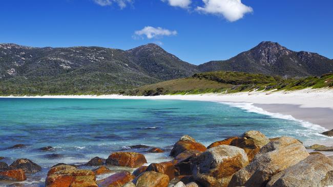
The Friendly Beaches
Situated a short drive north of Coles Bay is a long beach where you can walk for hours. Think white sand, rock pools and the red granite boulders more often associated with the Bay of Fires. It’s a popular spot for fishing and surfing, but the beach is unpatrolled and conditions can be dangerous. Keep an eye out for nesting birds, including Australian pied oystercatchers and hooded plovers. The Friendly Beaches campground is nearby. A parks pass is required.
Hopground Beach, Maria Island
Located at Maria Island National Park, a 30-minute ferry ride from Triabunna, Hopground Beach is about a 75-minute return walk or 30-minute return bike ride from the island’s main settlement at Darlington.
On the western side of the island, facing the Mercury Passage, the beach offers great snorkelling, crystal clear water and access to the famed Painted Cliffs.
“A lot of people know the Painted Cliffs but just before that area is the beautiful white sand of Hopground Beach,” Fry says. “And off that beach is some of the best snorkelling you can do in Tassie. It’s a protected area, but there’s huge crayfish and lots and lots of fish; it’s just a beautiful, calm spot. There’s also a rambling walk along the Painted Cliffs. It’s one of the state’s hidden gems.”
A parks pass is required.
WEST AND NORTH-WEST
Boat Harbour Beach
About 140km from Launceston and a 30-minute drive from Burnie, Boat Harbour Beach on the North-West Coast is one of Australia’s best beaches. It’s a quiet bay nestled between rocky headlands, with a small township perched above. Like Binalong Bay, it’s no state secret, but it is divinely low key. Its white sand, gentle waves, rock pools to explore and beautiful views make it a terrific family destination.
There is a playground built into the sand, a surf club nearby for a drink and something to eat, and with dolphins, seals and whales frequenting the bay, it is always a treat.
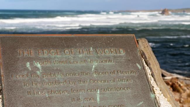
Arthur River
Situated very close to the westernmost point of Tasmania, about a two-hour drive from Burnie, the town of Arthur River is one of the most remote parts of Tasmania accessible by car.
There is a plaque on the coast, where the mouth of the Arthur River meets the sea, that says “Edge of the World”. It is a deserved title.
Facing straight into the wild seas rolling in from the Indian Ocean, lashed by the winds of the Roaring Forties, this is a place of violent beauty, pummelled by nature. The wild beaches are strewn with ancient logs washed in by the churning ocean as it meets the river current. It is one of the most spectacular places to see the sun set over the water.
With a population of little more than 20 people, Arthur River is certainly peaceful. Accommodation ranges from good campsites to holiday homes with picnic, barbecue facilities and meals at the local tavern.
Ocean Beach, Strahan (above)
Situated 6km west of Strahan’s town centre, Tasmania’s longest beach is known for its wild, pounding surf. The dunes behind the beach become a mutton bird rookery from October, when some return to their nests at dusk after a 15,000km winter migration.
“It has beautiful big dunes, it’s a massive long beach, and you can watch the shearwaters as they come in at nightfall and crash-land into the dune system above the beach,” Fry says. “The only issue is it’s a wild beach and there are rips.”
A road south of town leads to the start of the beach and a spot where you can look out over Hells Gates – the entrance to Macquarie Harbour – and across to Cape Sorell Lighthouse. Visit parks.tas.gov.au
What are your favourite Tassie beaches and why? We invite you to share your stories in our comments section below.
Add your comment to this story
To join the conversation, please log in. Don't have an account? Register
Join the conversation, you are commenting as Logout
‘They had to hold my throat open so I didn’t bleed out’
A Tasmanian local footballer has recalled the horror Bali accident which nearly killed him as he now sprints towards some unlikely Paralympic glory.
Meet the talented Tasmanians keeping traditional arts alive
In a world often dominated by consumerism and mass-production, these four talented Tasmanians are finding creative success in traditional arts while also showcasing Tasmania to the world