
South East Queensland weather: Cold snap across region
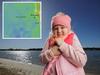
South East Queenslanders are once again waking up to temperatures well below zero in placers, with some “feels like” temperatures plunging to -4.8C this morning.


QLD News
Don't miss out on the headlines from QLD News. Followed categories will be added to My News.
South East Queenslanders are still waking up to freezing temperatures, despite a slight easing in conditions, with the mercury dipping below zero in multiple parts of the region.
Overnight, the Darling Downs and Granite Belt area felt the coldest conditions, with the apparent, or “feels like”, temperature down to -4.8C in Oakey and -4.7C in Dalby. In Dalby the lowest temperature recorded was -0.6C about 6.28am and -1.3C at 6.25am.
In Warwick, the lowest temperature was -0.8C at 3.54am with an apparent temperature at 0.2C, while Wellcamp recorded -0.8C.
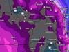
According to the Bureau of Meteorology, today will be the last day of the cold snap, with warmer temperatures expected, and more clouds and showers on the horizon.

Temperatures across Brisbane were as low as 9.4C, feeling like 7.4C, while the Sunshine Coast got to 7.3C with an apparent temperature of 7.8C.
Areas of Logan including Greenbank got down to 3.3C with a “feels like” temperature of 2.1C.
Bureau of Meteorology spokesperson Danny Johnson said the Wide Bay and Burnett region saw their lowest temperatures for decades.
“Bundaberg got down to 5.3C last night, it’s probably the coldest May morning since 1991, it could be as far back as 1968 but there’s a bit of missing data in between,” he said.
“The cold snap is pretty much over, yesterday was the coolest day.”
Places like Cairns were also cool overnight recording temperatures of 16C.
It marks the third day in a row of the cold blast in Queensland, with Tuesday predicted to have been the peak of the freezing temperatures.
According to the Bureau of Meteorology it has been on of the coldest starts to the month for a several years.
“May is one of those transitions months where we can see spikes in different weather patterns,” senior meteorologist Harry Clark said.
On Tuesday Oakey had the lowest apparent temperature of -9.8C.
Mr Johnson said over the next few days there will be a sunny outlook across the South East Coast.
“The worst of the colder temperatures are over, it will generally get warm,” he said.
“The overnight temperatures are getting back up to average.
“Around sort 8 to 13C across SEQ overnight with day time temps getting around 24 to 25C. Those mornings are warming up again.”
Mr Johnson said it would be cooler across the Darling Downs area with the coast experiencing the hotter temperatures.
“As we approach Thursday we will see a lot of coastal showers into next week and it could creep into the hinterland and Darling Downs,” he said.
“It looks like a wet mothers day.”
More Coverage
Originally published as South East Queensland weather: Cold snap across region

Reece Walsh melts hearts with touching gift to young fan
Reece Walsh has made one lucky Broncos fan’s day after the little boy was singled out from thousands of others to receive a special gift.

‘From C’s to straight A’s’: Meet Qld’s smartest student
A 17-year-old graduate will be named the state’s top student after receiving an ATAR of 99.95.
Guest list: Dutton’s $25k-a-head Brisbane fundraising soiree
Peter Dutton’s election fighting fund was boosted by more than $320,000 after a $25,000-a-head fundraiser at the home of a billionaire Brisbane businessman. SEE WHO ATTENDED

‘Everyone’s a Broncos fan’: Huge crowd turnout for community day
The Toowoomba Sports Ground was awash with maroon and gold during the Brisbane Broncos Community Day. See our photo gallery here.

‘Incredibly supportive’: Cody Simpson opens up on split rumours
Cody Simpson has addressed rumours about his relationship with Olympic gold-medallist Emma McKeon. WE’VE GOT THE SCOOP
Qld health boost as ambulance centre gets $8m upgrade
Queenslanders will get greater access to paramedics, specialist doctors and registered nurses following the announcement of a $8.31m health centre upgrade.