
Brisbane on alert as SEQ set for 24hrs of weather hell
Parts of South East Queensland have received up to 380mm of rain since Friday, and 150 roads are cut across the state, as the weather bureau warns the peak is yet to come. SEE LATEST
QLD News
Don't miss out on the headlines from QLD News. Followed categories will be added to My News.
Heavy rainfall will continue to smash South East Queensland throughout Saturday and Sunday after a drenching of more than 300mm overnight in some areas, leading to some areas going under emergency alert.
An emergency alert has been issued for Brisbane with heavy rainfall, possible severe thunderstorms and flash floods in the next 12 to 48 hours.
Rainfall totals of up to 150mm could be possible, while the Gold Coast and Wide Bay and Burnett were warned of falls of up to 300mm.
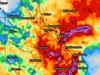
The Bureau of Meteorology issued a warning at 5pm on Saturday for “heavy, locally intense rainfall” over South East Queensland, including Brisbane and the Gold Coast.
“The peak in rainfall rates should occur during Sunday morning, with a potential clearance out of the southeast by late evening,” the bureau said.
Brisbane City Council urged locals to “prepare your home, warn neighbours and take care when driving”.
As of 4.30pm on Saturday more than 150 roads were flooded across Queensland, with RACQ urging motorists to limit travel in severe weather.
In the 32 hours to 5pm on Saturday, Queensland’s biggest rainfall totals were:
Rainbow Beach 378mm (9am Sat)
Tin Can Bay 300mm
Bundaberg 192mm
Lady Elliot Island 108mm
Maryborough 78mm
Gatton 59mm
Hervey Bay 79mm
Redcliffe 48mm
Brisbane 19.2mm
Ipswich 19.6mm
Coolangatta 8.4mm
Glasshouse Mountains 49mm
An emergency alert was also issued for residents in Redland City Council area at 2.40pm.
A wider severe weather warning was also current for the southeast coast from Bundaberg to Coolangatta, and extending inland for the next 24-hours before coming to a peak on Sunday morning.
Six-hourly rainfall totals between 90 to 150mm are likely, according to The Bureau.
Sandbags are available for collection at five Brisbane City Council locations including Darra, Morningside, Newmarket, Lota or Zillmere.
Heavy rainfall which could lead to life-threatening flash flooding is forecast to affect the Wide Bay and Burnett and South East coast with 24-hour rainfall totals likely to hit up to 300mm.
The bureau warned of a low-pressure system off the coast that’s expected to develop and move slowly south to southeast over the next 24 hours, but remain just offshore by Sunday morning.
The coast and the ranges are the highest risk area, with rainfall expected to increase in Brisbane tonight.
Gold Coast, Brisbane, Maroochydore, Gympie, Bundaberg, Ipswich, Coolangatta, Caboolture, Cleveland and Jimboomba are likely to be affected.
SCROLL DOWN FOR THE LATEST EMERGENCY ALERTS AND WARNINGS

Flash flooding is likely with rainfall expected to hit up to 160mm in six hours this morning, with the potential to become even more severe throughout the day.
The Bureau of Meteorology has forecast totals of up to 300mm that will smash the coastal and hinterland areas through to Sunday morning.
A flood warning has now been issued for the Mary River with moderate flooding possible at Tiaro from tomorrow afternoon. Meanwhile, minor flooding is likely at Dagun Pocket and Gympie from this afternoon.
Gold Coasters have also been warned to brace for the deluge.
Speaking to media on Saturday, Gold Coast Mayor Tom Tate said falls of between 200-300mm were expected to hit parts of the Glitter Strip from early Sunday morning.
“Brace yourselves,” he said.
“We all knew this was going to be happening.
“We will analyse it again at 3pm (to see if anything changes).”

He said at this stage minor flooding was expected but the rainfall would fall short of any forced evacuations.
Residents from low-lying areas have already taken 1500 sand bags to fortify their homes against the expected onslaught.
The Federal Government’s disaster management minister Murray Watt said he was “very concerned” about the rainfall continuing to hit the east coast with hundreds of Australian troops now mobilised across NSW and Victoria.
He said at this stage there did not seem to be similar concerns for Queensland, with the Wide Bay-Burnett region facing the biggest threats.
Floodwater rescues as more rain on the way
An elderly woman is lucky to be alive after her car was swept away in floodwaters south of Maryborough, prompting police to make an urgent plea to drivers to heed severe weather warnings.
The 85-year-old woman’s car was swept off a flooded causeway at Scrubby Creek Crossing near Bauple Dr about 3.25pm on Friday and pushed downstream into a tree.
Tiaro police had to pull her out of the vehicle through a back door and drag the woman to safety as the immense pressure of the floodwater weighed down on them.
Road Policing and Regional Support Command Acting Chief Superintendent Christopher Stream said the woman was “extremely lucky” to survive the ordeal.
“We have seen people, again, driving into flooded roadways and placing themselves at risk,” Superintendent Stream said.
“We’re going to again see localised flooding, we’re going to see localised heavy falls of water, and that flooding is going to be flash flooding.
“This is really, really simple. So for a matter of a couple of hours – wait.”

Superintendent Stream said flash flooding was likely, and urged drivers to listen to the warnings.
He said drivers would be fined hundreds of dollars if caught driving through a closed, flooded road.
“It’s very, very difficult for us to legislate against stupidity. But in some cases, again, we see people ignoring those warnings.
“We’re basically pleading with motorists to heed the warnings which are being issued by your local councils, your local disaster management groups, as well as the district disaster management groups, to stay out of floodwaters.”
A fatal example of flash flooding occurred in Aspley in December last year when a woman was found dead in the passenger seat of a car after being swept away in flood waters.
The woman, 44, and a male driver, 52, were driving out of Hungry Jack’s when the car lost traction.
It began floating in floodwaters from Little Cabbage Tree Creek and was swept 250m downstream.
The man was able to escape, but the woman’s body was found inside the car.
Superintendent Stream said these were the “very, very serious” consequences of driving through flood waters.
He urged drivers to stay safe to ensure their lives, and the lives of emergency responders, were not put at risk.
Noosa Mayor Clare Stewart said the Noosa local disaster management group had moved to an alert status, in line with a number of other local disaster management groups across South East Queensland.
“At this stage we’re on a watching brief and our disaster team are monitoring the event and are ready if required to take action,” she said.

Sunshine Coast lifeguard supervisor Trent Robinson said most of the protected beaches remained open this morning, October 22.
They included Noosa, Kings Beach, Mooloolaba and Alexandra Headland.
“The majority of our open stretch beaches are closed,” he said.
“I’d say after the noon incoming tide a lot more of the beaches will be closed.
“Make sure if those beaches are closed do not enter the water at all.”

It comes as areas north of Sunshine Coast were drenched last night with more than 300mm falling in Rainbow Beach and 286mm in Tin Can Bay from 9am yesterday to this morning.
Tops of 180mm fell in Bundaberg, while Gatton saw 55mm, Redcliffe had 38mm and Double Island saw almost 50mm overnight.
Emergency alerts and current warnings
Today, emergency alerts have been issued for the Biggenden and Dallarnil areas as well as for Noosa, Gympie and the Fraser Coast with the threat of heavy rainfall leading to flash flooding in the next 24 hours.
Meanwhile, the severe weather warning is covering heavy rainfall with the risk of flash flooding for areas between Seventeen Seventy to Coolangatta, extending inland.
A hazardous surf warning was also issued this morning for Fraser Island Coast, Sunshine Coast and Gold Coast waters.
A number of catchments across the state are under a flood watch including:
Belyando and Suttor Rivers to Burdekin Falls Dam (including Alpha Creek)
Dawson and Don Rivers
Comet and Nogoa Rivers (including Theresa Creek and the Gemfields)
Connors, Isaac and Styx Rivers and Plane Creek
Mackenzie and Fitzroy Rivers and Shoalwater and Water Park Creeks
Condamine Rivers
Wallam and Mungallala Creeks
Warrego River (QLD)
Paroo River (QLD)(Moderate flooding is occurring across the catchment)
The Big Warrambool River
Bulloo River (QLD)(Moderate flooding is occurring in the lower reaches)
Thomson River
Lord Mayor Adrian Schrinner said Brisbane City Council stood ready to activate evacuation and community centres across the city if required.
Currently, more than 126,000 prepacked sandbags are ready for collection at Brisbane depots in Dara, Lota, Morningside, Newmarket and Zillmere.
“We have also distributed more than 55,000 bags since staging our three super sandbag weekends,” Mr Schrinner said.
“Our new flood mapping is free and available so residents can learn the risks related to their property.”
Moreton Bay Regional Council also said it now had 105,000 sandbags available and was doing ongoing storm drain maintenance and large-tree monitoring as preparation.
Somerset Dam is likely to start releasing water into Wivenhoe Dam in the coming hours, but will be subject to change pending further rainfall, according to Seqwater.
Meanwhile, Gold Coast Mayor Tom Tate said it was “all hands on deck” as the city was placed on high alert on Friday morning.
“We’re on top of it but mother nature is unpredictable,” Mr Tate said.
Heavy rainfall is expected in the area over the weekend, with the potential for flash flooding, while hazardous surf conditions are also expected.
Road closures
Flash flooding has impacted roads around the state, with a number of roads under high priority alert.
Boonooroo Rd and Maryborough Cooloola Rd through Boonooroo Plains, Granville and Wallu, all near Maryborough, have water on the road in various areas.
Meanwhile, there’s flash flooding on Goodwood Rd in Alloway, Millmerran Inglewood Rd in Bringalily near Kooroongarra, Dawson Highway in Rolleston, Maryborough Biggenden Rd in Aramara west of North Aramara Rd, Bauple Woolooga Rd in Gundiah from Kanigan Ck and Beaudesert Boonah Rd in Coulson from Teviot Brook.
Rainfall totals from 9am Friday to Saturday morning
Rainbow Beach 378mmn
Tin Can Bay 283mm
Bundaberg 154mm
Lady Elliot Island 108mm
Maryborough 78mm
Gatton 55mm
Hervey Bay 52mm
Redcliffe 38mm
Glasshouse Mountains 32mm
Nambour 20mm
Brisbane 17mm
Ipswich 16.6mm
Coolangatta 8mm
More Coverage

Originally published as Brisbane on alert as SEQ set for 24hrs of weather hell

US nuclear attack submarine arrives in Qld
A nuclear-powered attack submarine has joined the USS Frank Cable in Brisbane. Find out why and see our exclusive first look inside the sub repair ship.

Queensland’s new ‘boot camps’ to tackle youth crime
Several new boot camp-style programs to target the youth crime crisis gripping Queensland will open up across the state, drawing comparisons to former premier Campbell Newman’s “expensive failure”.

‘Befriended rock stars, royalty and criminals’: Touching farewell for Beatty
A who’s who of Queensland television turned out to farewell their charismatic mate Michael Beatty at a celebration of life event on Sunday.

Major changes proposed to boost Queensland organ donation rates
Organ donation could become easier in Queensland under changes, including the consent process, proposed by the state government.

Teen girl hospitalised in Railway Estate crash
A 15-year-old girl hit by a car outside a Townsville pub is reportedly stable after being rushed to hospital with serious injuries Friday night.

Southside study reveals real cost of ignoring mental health
Taxpayers could save $482 million over the next decade if governments tackle root causes of mental distress in Brisbane’s southern suburbs and Logan, a groundbreaking study has found.