
Cyclone Owen: How to prepare in Central Queensland
UPDATE: See the latest Tropical Cyclone Owen details
Rockhampton
Don't miss out on the headlines from Rockhampton. Followed categories will be added to My News.
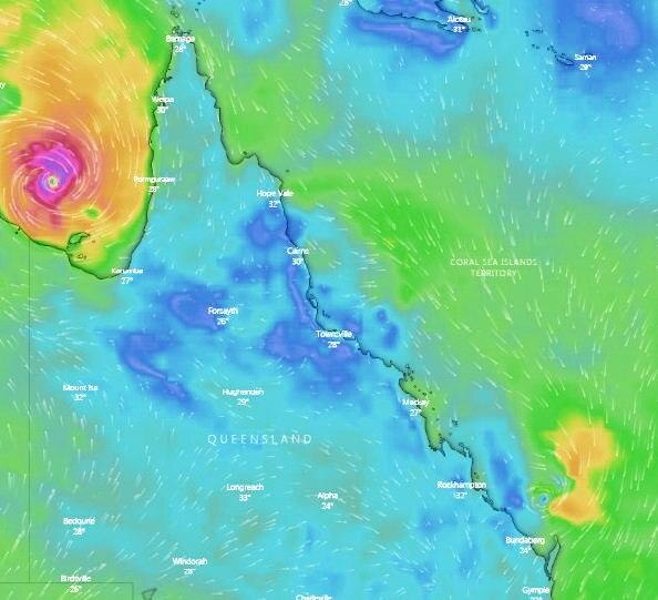
FRIDAY 4.20PM: AFTER strengthening overnight to a category four cyclone, Tropical Cyclone Owen is expected to have weakened to a category three cyclone early this morning.
Expected to have reached land by 5am today as a category four cyclone between Pormuraaw and Karumba, the system will have weakened further into a category one cyclone by 1pm this afternoon.
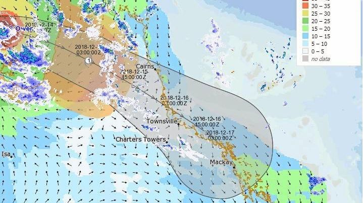
By Sunday, when Owen is expected to reach the Central Queensland coast, it will have weakened to a tropical low.
Bureau of Meteorology Weather Services Manager, Dr Richard Wardle, said Cyclone Owen may have slowed down, but it still has the potenital to brings severe weather conditions as it travels down Queensland.
"Due to this slow-down, Cyclone Owen is now likely to cross the Queensland coast on the western Cape York Peninsula later than initially anticipated," he said.
"Most likely early Saturday morning before moving in a southeasterly direction, rapidly weakening over land.
"While the system will weaken to a low over land, damaging to destructive winds will continue for several hundred kilometres inland as will areas of very heavy rainfall near the low."
Despite the weakening system, the Bureau said there was still a chance it could redevelop into a cyclone once it crossed back to the coast.
"There is also a moderate chance that Owen will re-develop into a tropical cyclone in the Coral Sea on Sunday or Monday if it moves over water," he said.
"This dynamic weather situation is compounded by severe thunderstorms for large areas of eastern Queensland with the potential for heavy rainfall due to the very moist tropical airmass in place and the upper low over New South Wales."
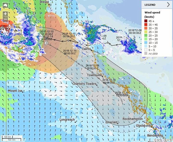
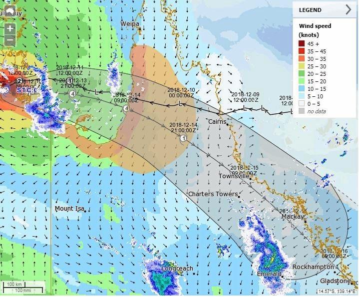
FRIDAY 2.15PM: THE Bureau of Meteorology has updated it latest tracking map of Tropical Cyclone Owen to show it making a slight left turn after it passes Mackay.
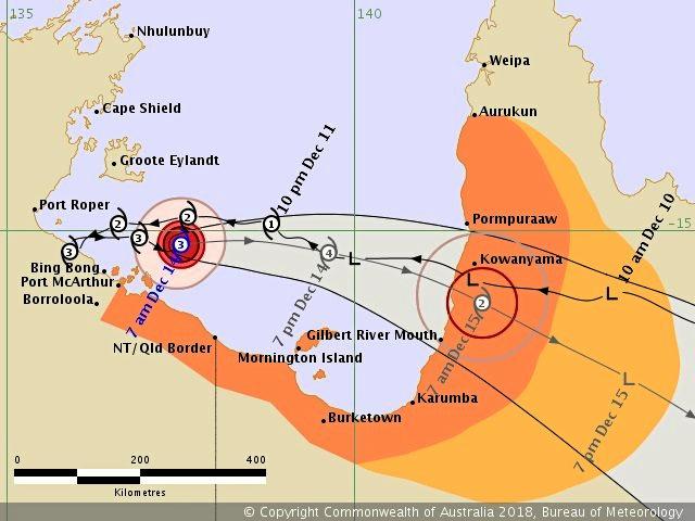
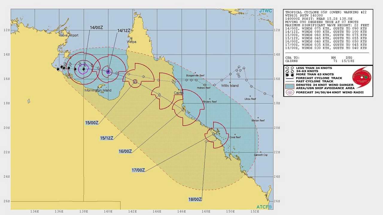
The category three system is located 195 kilometres north northwest of Mornington Island and is producing wind gusts of up to 195km/h.
The system is expected to strengthen as it tracks in an eastwards direction towards the southeast Gulf of Carpentaria coast.
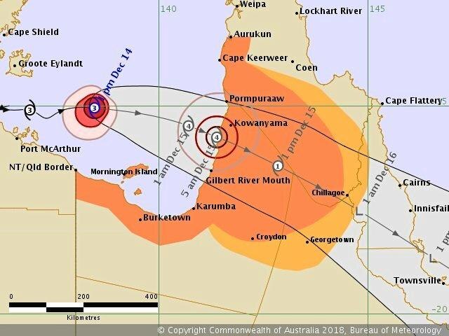
Owen is forecast to intensify to a category 4 system tonight prior to making landfall about the southeast Gulf of Carpentaria coast, between Gilbert River Mouth and Pormpuraaw.
After building to a category four cyclone, Owen will then weaken by Saturday morning into a category three cyclone and by 1pm Saturday the system will have weakened into a category one cyclone.
On Sunday when the system is expected to reach Central Queensland, it will have weakened further to a tropical low.
FRIDAY 12.30PM: CHAIR of the Local District Management Group, Councillor Tony Williams is urging residents of Rockhampton to be prepared for the oncoming Tropical Cyclone Owen.
In a statement Cr Williams said it is better to be safe than sorry.
"Obviously it would be fantastic for our region if the most severe weather doesn't reach us," he said.
"However cyclones are notoriously unpredictable, and it's always better to be over prepared than under prepared.
"I'd encourage all residents to make sure their Emergency Plan and Emergency Kit are up to date, to get rid of any debris in yards and gardens, and to keep monitoring the weather forecasts.
"Council will continue to provide sand free of charge at four locations throughout the region.
"Don't forget the storms travelling up from the south may also result in extra rain for us here.
"Let's hope for the best but prepare for the worst, and make sure we aren't caught out if the conditions worsen quickly."
Rockhampton Regional Council is providing sand for residents to fill their own bags free of charge at the following locations;
- Bridge St near Stapleton Park
- Dean St near Rodboro st
- Near the Exhibition Rd entrance of the Showgrounds
- Gracemere Swimming Pool carpark
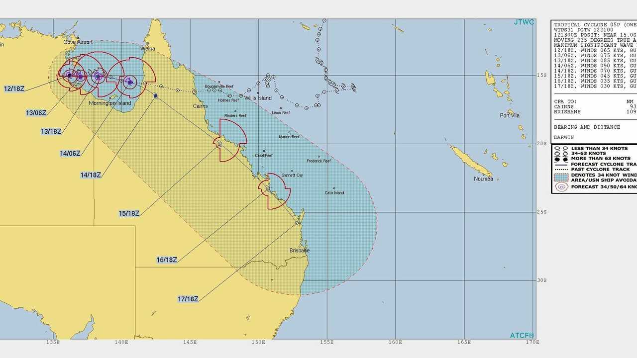
EARLIER: WITH strengthening Tropical Cyclone Owen tracking east over the Southern Gulf of Carpentaria today communities along the coast of Queensland are preparing for severe weather in coming days.
The latest update from the Bureau of Meteorology indicates the cyclone will strengthen into a category four cyclone by 1pm today while it is tracking between the Northern Territory coast and the Queensland Coast.
It is expected to reach the Queensland coast between Karumba and Pormpuraaw on Saturday morning where it will have wakened into a category two cyclone.
With the system tracking east, it is expected to impact towns along the Queensland coast from the cape to south east Queensland.
By Saturday night, the cyclone is expected to weaken into a tropical low, where it will continue to move down the coast.
By the time the system reaches the Capricornia coast late Sunday night or early Monday morning, the topical low will have weakened significantly.
Despite the cyclone being downgraded to a tropical low, it is still expected to bring damaging winds and heavy showers with the potential for flash flooding in the region.
The Rockhampton Regional Council have made sandbagging stations in Rockhampton and Gracemere and is encouraging locals to be prepared for any potential wild weather.
Residents can find sandbagging stations at;
- Bridge Street near Stapleton Park
- Dean St opposite Mason St
- Exhibition Road entrance of the showgrounds, and
- Gracemere Swimming Pool carpark
Over the weekend, there is a high chance of showers for Rockhampton and Yeppoon as well as the potential for thunderstorms in the region.
For Friday, there is a 75-90 per cent chance of rain throughout the day, and that goes up to 90-100 per cent for Saturday and Sunday.
With the biggest falls predicted for Sunday, the Bureau says there is a fair chance that Rockhampton could see anywhere between 50 and 150mm during the day as the tropical low moves towards the region.
For Yeppoon, a possible 50 to 200mm could fall on Sunday.

With the widespread and potentially heavy rainfalls across the state, RACQ has warned drivers to be aware of the impact to roads.
RACQ Spokesperson Clare Hunter said conditions across the state mean flash flooding was highly likely.
"Heavy rain can impact road conditions in an instant, and so we're urging motorists to stay safe and think smart, never to drive though flood waters and delay travel altogether if they can," Ms Hunter said.
THURSDAY: AS Tropical Cyclone Owen moves towards the Queensland coast, Rockhampton Regional Council is preparing for a severe weather event.
The Local Disaster Management Group has been placed on alert after the Bureau of Meteorology advised the region would be impact by TC Owen this weekend.
The current forecast indicates the cyclone will bring damaging winds and heavy rain, with the potential for flash flooding by Sunday or Monday.
Chair of the LDMG, Councillor Tony Williams, is urging residents in the region to be prepared for the wild weather predicted this weekend.
"We are taking precautions around the region as we did yesterday, making sure the we are preparing our emergency plans," he said.
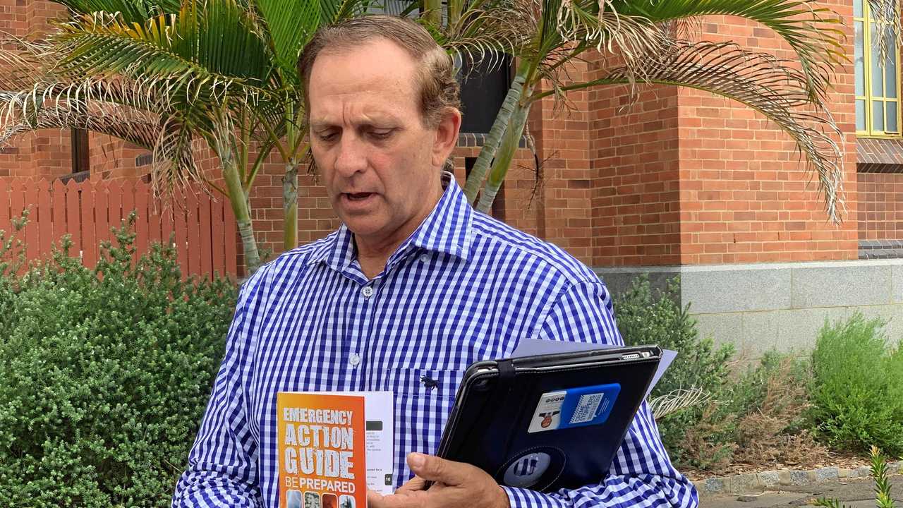
"It is vitally important that people are prepared.
"Complacency is a big problem that we have faced when people unfortunately don't take heed to some of the information.
"It really is vital that our community is prepared for the damaging winds and heavy rain heading our way.
"In your Emergency Kit make sure there are things like a radio, a torch, charged power banks, a first aid kit, and enough food and water for three days.
"Getting rid of any debris in advance can make a huge difference. Trim any branches over your roof, clean out yards, and remember you can take any green waste or recycling to our landfill sites for free."
Saying the council have set up four sandbagging stations across the region, Cr Williams is encouraging all residents to take advantage of the free service.
"Council will be providing sand for residents to fill their own bags with at four locations from 4pm today ," he said.
"Bridge Street near Stapleton Park, Dean Street opposite Mason Street, the Exhibition Road entrance of the Showgrounds, and the in the car park at Gracemere Swimming Pool.
"We will continue to monitor the levels throughout the coming days, ensuring more sand is provided if needed.
Comparing this weather event to 2013s TC Oswlad, Cr Williams has said TC Owen is also a small, fast moving system.
"The indications are that there will be heavy rain and gale force winds," he said.
"It is too early to predict the exact location but the tracking, but the early forecasting is saying that it is heading inland our way, similar to Oswald.
"It is a fast moving system so hopefully it can go through reasonably quick without too much damage."
The Bureau has also issued a flood watch for parts of the state, saying that widespread flooding is likely across the Flood Watch area over the weekend and into next week with moderate to major flooding possible in some areas.
Catchments that are likely to be affected are:
- Settlement Creek
- Nicholson River
- Leichhardt River
- Lower Flinders River
- Norman River
- Gilbert River
- Coleman and Edward Rivers
- Mitchell River
- Staaten River
- Daintree River
- Mossman River
- Barron River
- Mulgrave and Russell Rivers
- Johnstone River
- Tully River
- Murray River
- Herbert River
- Black River
- Ross and Bohle Rivers
- Haughton River
- Belyando and Suttor Rivers to Burdekin Falls Dam
- Cape River to Burdekin Falls Dam
- Burdekin River to Burdekin Falls Dam
- Burdekin River downstream of Burdekin Falls Dam
- Don and Proserpine Rivers
- Pioneer River
- Dawson and Don Rivers
- Comet and Nogoa Rivers
- Connors, Isaac and Styx Rivers and Plane Creek
- Mackenzie and Fitzroy Rivers and Shoalwater and Water Park Creeks
- Calliope River
- Boyne River
- Baffle Creek
- Kolan River
- Burnett River
- Burrum and Cherwell Rivers
- Mary River
Originally published as Cyclone Owen: How to prepare in Central Queensland

LNP over KAP? Premier in tit-for-tat over not pulling rank
Steven Miles has engaged in a tit-for-tat with journalists over why he won’t demand Labor preference the LNP over Katter’s Australian Party amid abortion law concerns.

Twist in alleged rape case stalled over DNA delay
An alleged violent offender held on remand, accused of raping his pregnant partner, has had his bail application denied following a stunning DNA revelation.

‘Devastating’: Greyhound’s ghastly track injury, death reignites racing debate
The death of a greyhound following a neck-breaking crash at a Qld meet has attracted the furore of anti-racing advocates, but industry chiefs insist it was a “freak” accident on “one of the best tracks” in the state. *Distressing content.
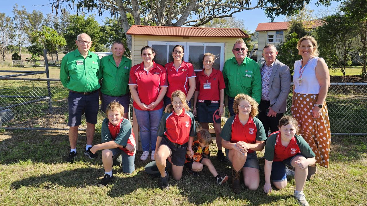
Tiny Milman school provides massive support to locals
A local school with only four students is punching above its weight when it comes to community engagement. SEE MORE

Four opportunities to kill: Teen’s vicious assault on girlfriend shocks judge
A Queensland judge of 20 years has been shocked by the details of a 19 year old’s incredibly vicious attack on his girlfriend of only four weeks claiming the assault could have killed her. Warning, distressing content

1000+ photos: Qld’s most amazing weather shots over the years
Queensland is knwon for its wild weather – we look back at the most stunning and shocking storm photos from recent years. SEE THE FULL GALLERY