
27k blacked out as tornado, storms dump 52mm in hour, heatwave hits power grid
Severe heatwave conditions are expected to continue impacting the state’s energy supply over the next 48 hours, with high temperatures forecast for the southeast after a series of wild storms lashed the region, leaving thousands without power. LATEST FORECAST
QLD News
Don't miss out on the headlines from QLD News. Followed categories will be added to My News.
Severe heatwave conditions are expected to continue impacting the state’s energy supply over the next 48 hours, with high temperatures forecast for the southeast on Wednesday after a series of wild storms lashed South East Queensland.
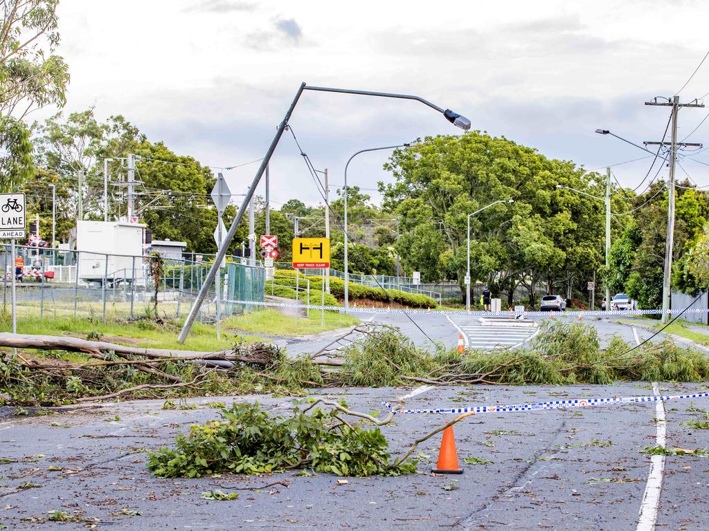
Trees fell on train tracks, dozens of power lines came tumbling down and more than 100,000 lightning strikes were recorded in the barrage, with more wild weather on the way overnight.
Storms continued overnight as the BOM confirmed a tornado ripped through Browns Plains on Tuesday night after pictures flooded social media of the wild weather.
The tornado was likely a result of a short supercell storm resulting from the severe storm activity experienced in the South East, The BOM said.
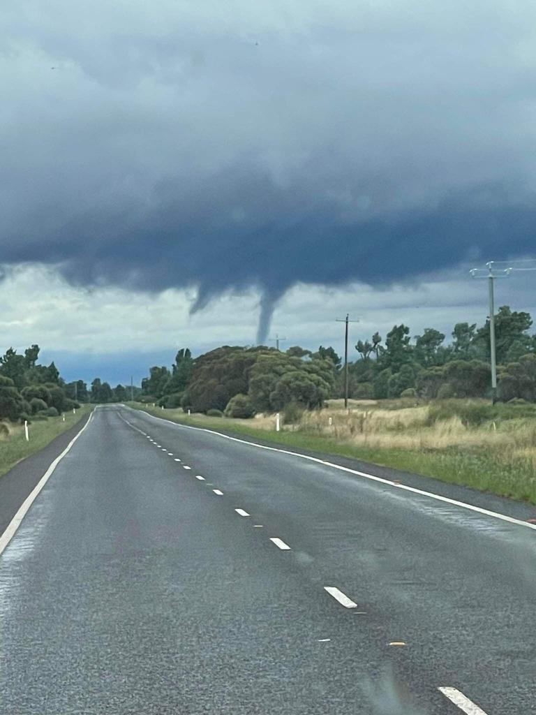

Meteorologist Matthew Bass said the tornado likely formed from underneath the supercell as it crossed over Logan Central.
“The funnel of the tornado is clearly visible, but it is hard to say how severe it was without seeing where it meets the ground,” Mr Bass said.
“They [tornadoes] tend to be brief but if you happen to be near it at the time you would experience some significant wind damage.”
Kuss Road received 61mm of rain in 30 minutes, Tallegalla has received 31mm in 15 minutes and Rathdowney recorded 52mm in the hour between 4-5pm.
It was all hands on deck with Queensland Fire and Emergency Services assisting State Emergency Services and Queensland Police Service with ‘rapid damage assessments’ in the Logan area, after it experienced more than 14,000 power outages.
More than 40 homes reported various hazard issues relating to roofs or debris after the supercell storm ripped through the area.

Six fire crews of level two technical rescue firefighters travelled to more than 900 Logan addresses to conduct emergency assessments, prioritising make-safes as required, but only six houses had minor to moderate roof damage.
An Energex spokesperson said there were around 90 wires down across the network and extensive damage has been recorded in the Logan City Council area.
“Crews will be working through the night and into tomorrow in a marathon effort to restore power,” said the spokesperson.
“We ask everyone to be aware of fallen powerlines, stay well away and report these life-threatening hazards to triple-0 or call Energex on 13 19 62.”

Meanwhile trees fell onto the tracks at Woodridge, causing lengthy delays for travellers using the Beenleigh and Gold Coast train lines.
Woodwidge recorded more than 3,600 power outages, followed by Rochedale South (3,100), Pimpama (1,545) and Kuraby (1,277).
Energex has been unable to confirm power restoration times, saying repair estimates can only be provided when a full damage assessment is done.
“We cannot provide accurate restoration times until the damage has been fully assessed, but we’ll update Energex’s Outage Finder as we know more.”
“We appreciate everyone’s patience in the heat and can assure customers every available crew is on the job.”

A spokesperson for Energex said the bulk of its customers affected by blackouts is due to storm related outages.
Energex is yet to assess the full severity of the damage, with some crews having to wait until severe storm conditions pass.
“It will take time for our crews to assess the damage before they can even commence repairs,” the spokesperson said.
“In some places where wet weather conditions are still severe, crews will need to wait until those conditions subside, but we will have every available crew on the job.”
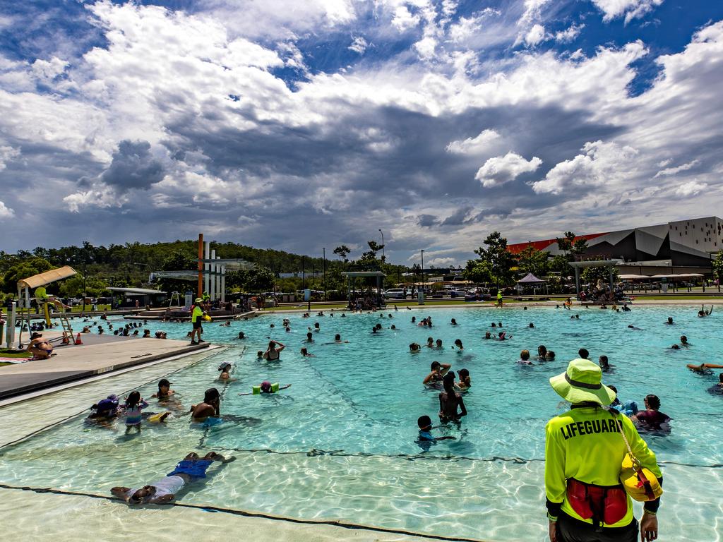
Brisbane residents weren’t spared from the heatwave’s brunt with the temperature reaching 32.8C at 11am.
The city’s current apparent hit 36.5C late this morning.
Queenslanders have been warned to brace for high humidity up to 90 per cent and ”unusually high” 40C apparent temperatures.
The heatwave conditions will push temperatures 5-10C above average.
Meteorologist Brooke Pagel says that the uncommon high dew points, which represents how much moisture is in the air, will also contribute to the soaring temperatures.
“When you have high dew points and high humidity, which is not actually common when you see humidity and high temperatures together, it will actually feel closer to 4C in southeast Queensland,” she said.
“With that combination, the ‘feels like’ temperature is really going to increase even though the temperatures in some cities even if their temperatures hover around 34-36C.”
QLD’S HOTTEST PLACES AT 11AM ON TUESDAY
Roma – 37.3C
St George – 36.5C
Cunnamulla – 36C
Lochington – 35.4C
Charleville – 35.1C
Blackwater – 35C
Rolleston – 34.5C
Thargomindah – 34.5C
Blackall – 34.4C
Longreach – 34.1C
Emerald – 34C
Gayndah – 33.5C
Rockhampton – 33.3C
Brisbane – 32.8C
Sunshine Coast – 32.5C
Gladstone – 32.3C
Gold Coast – 32.2C
Queensland‘s heatwave shows no sign of slowing down as temperatures continue to soar into the high 30s past 12:30pm.
Across the state, temperatures have jumped between 2 and 4 degrees across the last two hours, with Brisbane soaring from 32.8C to 34.2C.
In the central west and the central highlands, temperatures are crawling their way to the 40s as places reach between 35 and 37.7.
Lochington remains the hottest suburb in Queensland as of 12:30pm, reaching 37.7 and an apparent temperature of 43.5C.
QLD’S HOTTEST PLACES AT 12:30PM
Lochington – 37.7 – feels like 43.5
St George – 37.6C
Blackwater – 36.7C
Rolleston Airport – 36.6C
Emerald – 36.3C
Oakey – 36.3C
Charleville – 36.2C
Roma – 36.1C
Trepell – 36C
Chinchilla – 35.8C
Clermont – 35.6C
Dalby – 35.6C
Rockhampton – 35.5C
Biloela – 35.3C
Wellcamp Airport – 35.2C
Longreach – 35.1C
Blackall – 34.6C
Century Mine – 34.3C
Brisbane – 34.2C
Gladstone – 34.1C
Winton – 33.9
Gold Coast – 31.8C
Sunshine Coast – 30.9C
Humidity is set to rocket between 80 and 90 per cent across the southeast in conditions that are unusual for the area.
“The humidity levels in Brisbane and the Gold Coast are what you would see in Darwin and Cairns this time of year,” said Ms Pagel.
Brisbane will reach a dew point of 21C, which BOM says means that going outside will be “very, very sweaty”.
“Today and tomorrow, it is going to be very, very, uncomfortable for a lot of people.”
Ms Pagel said that meteorologists consider anything above a dew point 18C to be “uncomfortable”.
According to BOM, the heatwave is the result of a trough pushing towards the east coast mixed with tropical moisture from northern parts of the state.
“When that trough slowly shifts east, it is bringing down moisture from the Northern Peninsula and creates these humid conditions,” Ms Pagel said.
Ms Pagel said that a chance of showers late on Wednesday meant that even more moisture would be brought in and humidity could continue to skyrocket before relief on Thursday.
“The unusually humid conditions will stick around on Wednesday, but once that trough shifts east and having those showers move through, it will cool down and the heatwave will fall off,” she said.
“Thursday onwards we can look forward to a little bit of relief, but it is still your typical summer in southeast Queensland.”
Severe heatwave conditions will be expected for most of the southeast reaching from Brisbane north up to Gladstone.
South East Queensland’s maximums will reach in excess of 35C today while parts of the state’s southwest, including St George, Bollon, Cunnamulla and Dirranbandi, will get to 40C.
The Brisbane CBD is expected to reach 35C today and 36C on Wednesday, while it will be 38C in Gayndah and Gatton.
Queenslanders are being asked to reduce their electricity consumption over the next two days as the heatwave drives a record demand for electricity.
The state is forecast to reach a demand for electricity on Tuesday afternoon, close to the 2019 record and well above the current 2021 peak record.
Powerlink chief executive Paul Simshauser said the supplier was encouraging electricity customers to reduce their energy consumption, where safe to do so, over the next two days.
He said reducing electricity consumption – especially in the afternoon and evening – could ensure available supply is used in the fairest and most efficient manner across industry, the community and essential services.
“By reducing electricity use at home and in your workplace, the community can help ensure that power system security is maintained in Queensland,” he said.
“Your safety and wellbeing is important so only reduce energy consumption if it is safe to do so.”
Mr Simshauser reminded Queenslanders that in the event of a supply outage, emergency services and priority groups such as hospitals and nursing homes will be given priority access to electricity supply.
He encouraged people to remain up to date with the state’s energy supply and to do their bit to keep consumption low while temperatures soared.
How can Queensland householders reduce their electricity usage?
– Reducing the number of rooms being airconditioned or running your airconditioner a couple of degrees higher.
– Turning off computers, TVs and other household appliances in standby mode.
– Turning off your pool pumps and second fridges.
– Turning off unnecessary interior and exterior lights.
How can commercial businesses reduce their electricity usage?
– Limiting the use of air conditioners (unless needed for health or medical reasons) and if air conditioners need to be used, set them to 24C or above;
– Reducing the amount of interior and advertising lighting used;
– Turning off water heating systems and urns, except for food and beverage preparation and cleaning.
– Turning off advertising lighting, heating appliances for swimming pools or spas and any unnecessary exterior lighting.
HOTTEST PLACES TODAY
St George – 40C
Bollon – 40C
Cunnamulla – 40C
Dirranbandi – 40C
Goondiwindi – 40C
Emerald – 39C
Blackall – 39C
Charleville – 39C
Roma – 39C
Surat – 39C
Quilpie – 39C
Gatton – 38C
Gayndah – 38C
Blackwater – 38C
Rolleston – 38C
Taroom – 38C
Augathella – 38C
Thargomindah – 38C
CURRENT TEMPS & 7-DAY FORECASTS


Originally published as 27k blacked out as tornado, storms dump 52mm in hour, heatwave hits power grid

Non-urgent surgeries suspended at Toowoomba and Logan
Some non-urgent surgeries have been suspended at Toowoomba Hospital due to the emergency department being overwhelmed and Logan due to staffing issues.

Wild wind, lightning, rain: Flights stopped as ‘microburst’ smashes SEQ
Parts of Brisbane, Logan and Ipswich have been hit with wild weather as a large band of rain with isolated storms ripped through the Southeast on Wednesday afternoon.

Gun-toting eshay’s bullet-blazing pub hold-ups caught on CCTV
He stormed the pubs, terrorised security and let his gun do the talking - but he didn’t end up stealing anything “simply due to incompetence”.

Two arrested after Bruce Hwy drive-by shooting
Two people have been arrested after shots were fired from a moving vehicle on the Bruce Hwy north of Brisbane on Wednesday afternoon.

Woman fights to keep $3.3m home … 18 months after selling
She signed a contract to sell the luxury Sunshine Coast waterfront home, but 18 months on she doesn’t want to hand over the keys.

Mum charged with murder of disabled teen son
A Queensland mother has been charged with the murder of her disabled teenage son, who was found semiconscious at an address in Daisy Hill, before dying while in a coma in hospital.