
Severe storm warning: Large hail, heavy rain, damaging winds
Fierce thunderstorms smashed into parts of southeast Queensland delivering damaging winds and heavy rain.
QLD News
Don't miss out on the headlines from QLD News. Followed categories will be added to My News.
Wild storms smashed into some parts of southeast Queensland this afternoon with reports of damaging winds and heavy rainfall.
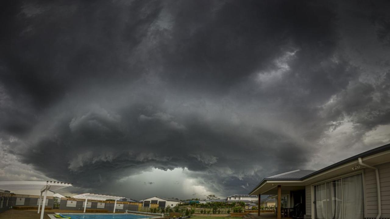
Mormonsk Vilanski captured stunning storm clouds over Karalee, which he labelled the “doughnut of doom”.
At Booval, residents reported “horizontal rain. Strong winds. Fierce bolts and thunder”.
The storms were fast moving, delivering almost 40mm in some parts in less than 20 minutes. Toowoomba has been hard hit, with 20mm falling in parts of the city.
This storm is looking like it will deliver a bit of rain, so pack your patience on the commute home, drive to conditions, and put your lights on. pic.twitter.com/VtxXeIA7T7
— RACQ (@RACQOfficial) March 8, 2021
At 5.30pm the radar was showing what looked to be potential storms over the Somerset Dam and Highvale region moving southeast toward greater Brisbane, while storms were also seen over the Allora and Warwick region as well as at the border near Murwillumbah. These had reduced to rain rather than storm cells by 7pm.
The Bureau of Meteorology updated a severe thunderstorm warning at 8.36pm for heavy rainfall.
The update was for people in parts of Central Highlands and Coalfields and Central West forecast districts.
The warning said severe thunderstorms were likely to produce heavy rainfall that may lead to flash flooding in the warning area over the next several hours.
“Locations which may be affected include Longreach, Isisford, Barcaldine and Blackall,” the warning said.
Severe thunderstorms are no longer occurring in the Maranoa and Warrego and Darling Downs and Granite Belt districts and the warning for these districts is cancelled.
Some punchy storms moving across the southeast this afternoon.
— Tony Auden (@TonyAuden) March 8, 2021
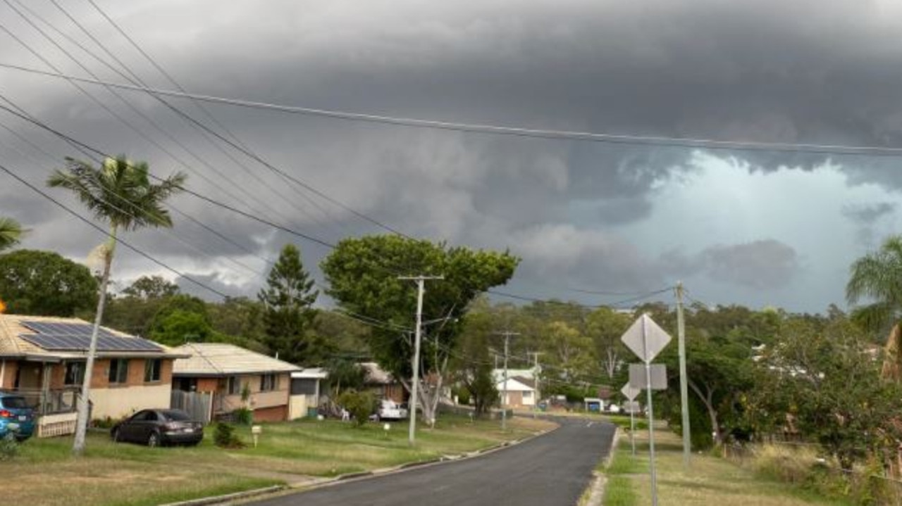
How’s this shot from Bundamba a short time ago?!?
📸 Amber Rodgers pic.twitter.com/gUEeUJSekq
EARLIER
The Bureau of Meteorology updated a severe thunderstorm warning at 4.19pm for damaging winds, large hailstones and heavy rainfall.
The update was for people in parts of Central West, Channel Country, Maranoa and Warrego and Darling Downs and Granite Belt forecast districts.
The warning said the storms “may lead to flash flooding over the next several hours in parts of the Darling Downs and Granite Belt district”.
“Locations which may be affected include Stanthorpe and Texas,” the warning said.
“Severe thunderstorms are likely to produce damaging winds and heavy rainfall that may lead to flash flooding over the next several hours in parts of the Central West, Channel Country and Maranoa and Warrego districts. Locations which may be affected include Charleville, Cunnamulla, Isisford and Bollon.”
The update was to an earlier severe thunderstorm warning issued at 2.51pm for damaging winds, large hailstones and heavy rainfall for people in parts of Central West, Channel Country, Maranoa and Warrego and Darling Downs and Granite Belt forecast districts.
“Locations which may be affected include Stanthorpe, Goondiwindi and Tara,” the warning said.
“Severe thunderstorms are likely to produce damaging winds over the next several hours in parts of the Central West, Channel Country and Maranoa and Warrego districts. Locations which may be affected include Cunnamulla, Quilpie and Wyandra.”
Earlier this afternoon, BOM meteorologist Kimba Wong said the Lockyer Valley/Gatton region was where the most eastern storm was about 2.15pm.
“And then there are storms roughly up from Gatton all of the way up to Carnarvon National Park.”
Locations southeast of Toowoomba had received 17mm of rain by about 2pm.
“We may see some remnant shower activity coming through metro areas across Brisbane and the Gold Coast this afternoon, but in terms of what mode it’s in by the time it gets here it’ll probably be on a weakening trend,” Ms Wong said.
A deepening surface trough over eastern Australia will combine with a moist and humid air to bring daily widespread showers and thunderstorms to southern Qld this week. Severe thunderstorms are possible. For the latest forecasts: https://t.co/2CRnHuMpzl pic.twitter.com/3XcLCyYsqv
— Bureau of Meteorology, Queensland (@BOM_Qld) March 8, 2021
11.30AM
The Bureau of Meteorology is warning that severe storms with large hail, damaging wind gusts and heavy rainfall could impact parts of southern Queensland today.
BOM issued the thunderstorm forecast at 11.30am, warning that severe thunderstorms were possible over the southern and central interior, and likely near the NSW border.
Meteorologist Kimba Wong said showers and potential thunderstorms are forecast to impact parts of southern inland and northern Queensland for the next few days.
“There is the potential there for some useful landfall totals coming through,” she said.
“Broadly speaking, mostly 10-20mm across most of the southern inland parts of the state … up to 60-80mm if you get a decent storm roll through.
“That activity is expected to remain inland from the populated centres of the southeast for at least the next few days.”
There is a risk of severe thunderstorm activity about the Maranoa and Warrego and western Darling Downs and Granite Belt districts this afternoon and evening.
â›ˆï¸ Monday Thunderstorm Forecast â›ˆï¸ Severe storms with damaging wind gusts, heavy rainfall and large hail are possible over the central and southern interior, and likely near the NSW border today. Warnings will be issued as required here: https://t.co/hGbGDJZVlWpic.twitter.com/lHwf3Rmlym
— Bureau of Meteorology, Queensland (@BOM_Qld) March 8, 2021
Along the southeast coast and Brisbane region, mostly sunny conditions are expected until Wednesday.
“There might one or two showers or thunderstorms around the place (today), more likely inland, like the Lockyer Valley, Scenic Rim and west from there,” Ms Wong said.
“Maybe towards Wednesday seeing some thunderstorm activity making its way to the coast, Brisbane and the Gold Coast as well.
“That storm potential around Brisbane will be highly dependant on a southerly wind change that will be pushing through, so the timing is quite critical for the development around Brisbane itself.”
Brisbane is set to hit 30C today and 32C on Wednesday.
“Particularly in the southeast we’ve had reasonably low humidity for the past few days, it’s looking like that will increase midweek, so on Wednesday, before cooling down a bit,” Ms Wong said.
Originally published as Severe storm warning: Large hail, heavy rain, damaging winds

Lockdown to luxe: Iconic Brisbane street’s stunning fightback
One of Brisbane’s most famed high streets is set for a once-in-a-generation transformation as a wave of luxury unit developers move in. SEE WHAT’S COMING

How they work, who they target: The scams catching out everyday Qlders
Millions have been lost by everyday Qlders over the years to elaborate scams. We breakdown the worst – who were the victims, how much they lost and how the scams worked.

Watch: Police release CCTV after fight at Wynnum pub
Police have released footage of two men who they believe may be able to help their investigation into an assault at Wynnum this month.

‘Told the girls to run’: Dire warning after heinous national park act
A support worker’s day out with two young girls turned to horror when they came across a man in a popular national park.

GALLERY: 110+ fabulous faces at Childers Festival 2025
Stilt walkers, drummers and dancers turned Childers’ main street into a magical carnival at the weekend as the town’s signature festival drew record crowds.

Hospitality giant’s eye-catching addition to SEQ dining dynasty
One of Brisbane’s most rapidly expanding hospitality groups is set to gain another venue.