
Full list: Every NSW suburb at flooding risk
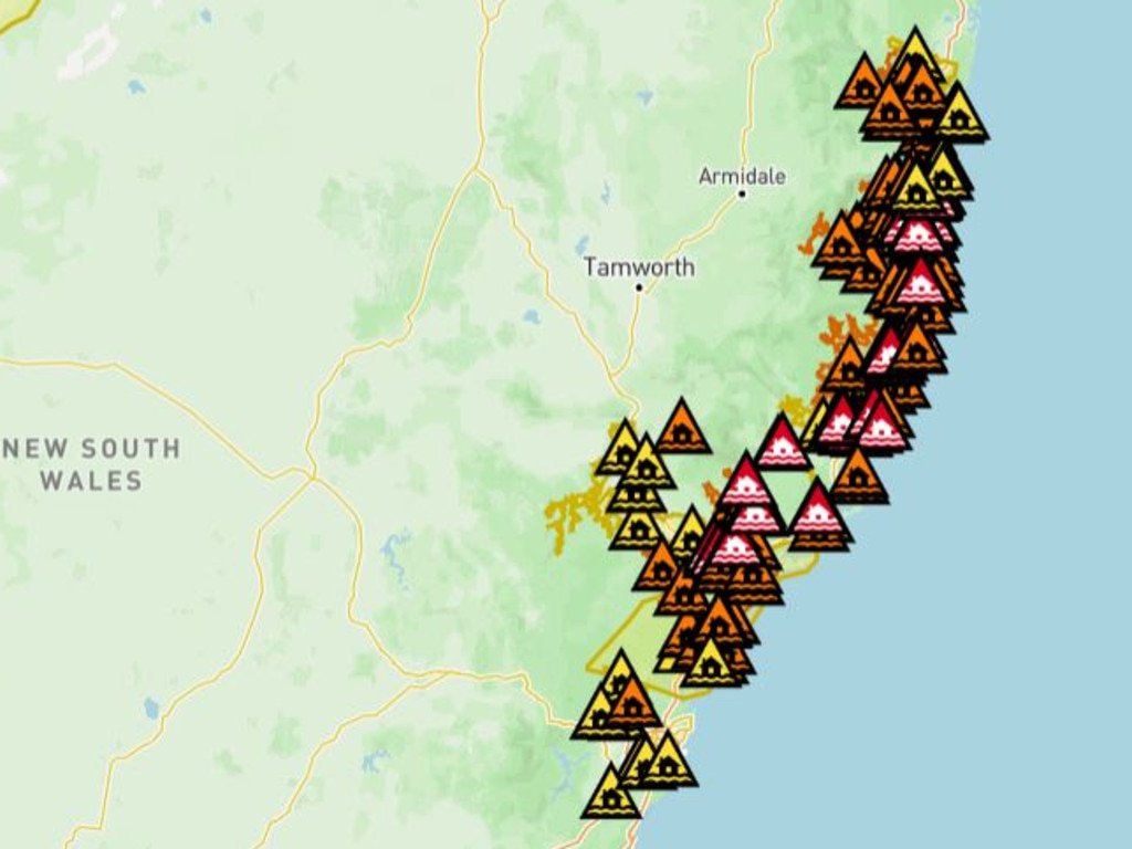
More than 100 towns and suburbs across greater Sydney, the Central Coast, Hunter Region and Mid-North Coast are at risk of becoming inundated by flooding. See all the suburbs at risk here.

NSW
Don't miss out on the headlines from NSW. Followed categories will be added to My News.
More than 100 towns and suburbs across greater Sydney, the Central Coast, Hunter Region and Mid-North Coast are at risk of becoming inundated as one of NSW’s most severe flood disasters in recorded history continues to unfold.
The NSW SES has issued red-alert emergency warnings urging residents to evacuate, move to higher ground or shelter in place, more than 150 warnings in place as of 11am on Friday.
There are three types of warning levels:
Advice: An incident has started. Stay up to date as the situation changes.
Watch and Act: There is a heightened level of threat. Conditions are changing and you need to start taking action now to protect you and your family.
Emergency Warning: An Emergency Warning is the highest level of warning. You may be in danger and need to take action immediately. Any delay now puts your life at risk.
Emergency Warning
LATEST:
* Parts of Rosebrook, Hillsborough, Lambs Valley (along Maitland Vale Road, Anambah and Gosforth flooding) 10:40am today. Seek shelter now.
* Parts of Wauchope Flooding: 13 h ago at 7pm last night ‘evacuate now’ due to major flooding at properties on parts of Rocks Ferry Road, Hastings Street, River Street, Alma Street, Parker Street and Nelson Street, and properties on parts of Bain Street. You must evacuate now because floodwaters will be impacting the area soon.
* Telegraph Point- The Hatch, Blackmans Point flooding: 14 h ago last at 6:15. Shelter now at properties along Mooney Street, Telegraph Point Road and Hacks Ferry Road, and properties along East Road, Hosking Road, Blackmans Point Road, Elfords Road, The Hatch Road and Mcmillan Drive.
* Parts of Wauchope Flooding: 14 h ago. Shelter now, too late to leave safety as evacuation routes are likely to be cut off from parts of Wauchope between King Creek and Stoney Creek Road
* Rawdon Island Flooding: 14 h ago from 6:12pm yesterday. Shelter now due to major flooding across the whole of Rawdon Island.
* North Shore- Port Macquarie Flooding: 14 h ago, shelter now due to Moderate to potential Major flooding in North Shore, Limeburners Creek and Riverside.
Marina Crescent and Old Punt Road, Urunga flooding- Evacuate now: 16 h ago at 4:38pm yesterday
* Newry Island Flooding: 16 h ago at 4:34pm yesterday. Evacuate now warning for Newry Island Drive and Island Place.
* Croki and Surrounds including Moto Flooding: 16 h ago from 4:33 pm last night. Widespread flooding in Croki and Surrounds and Moto
* Newry Island South Flooding: 16 h ago from 4:33pm yesterday. Evacuate now due to rising, unsafe flooding in parts of Newry Island South
* Low lying parts of Macksville Flooding: 17 h ago from 4:04 pm yesterday. Evacuate now from parts of Ferry Street, William Street, parts of Bellevue Drive, parts of Cooper Street, Nursery Road, Casey Drive, Egan Street, Egan Lane and Oxley Street.
* Low lying parts of Macksville Flooding: 17 h ago from 4:03pm yesterday. Evacuate now due to major moderate flooding for Properties along Jellico Street, Sturdee Street, properties along Tilly Willy Street, properties in the Macksville CBD, properties along Wallace Street and East Street.
* Low lying areas of Bowraville Flooding: 18 h ago at 3:21pm yesterday. Shelter now due to hazardous moderate flooding for properties along parts pf South Arm Road, High Street North Arm Road and adjacent streets/lanes, properties along Park Street, George Street, Wilson Road, Carbin Street and adjacent streets.
* Parts of Gumma Flooding: 19 h ago from 3:20pm yesterday. Move to higher ground due to major flooding at all properties on Gumma Road, Figtree Road, Barntts Road, Boultons Crossing Road, Wallaby Drive, Waterford Drive, Robert Hughes Road and Warrell Waters Road.
* Parts of Nambucca Flooding: 19h ago from 3:19pm yesterday. Evacuate now due to major major flooding at all low lying properties adjacent to the Nambucca River.
* Bellinger River Tourist Park, Repton Flooding: 19h ago from 2:36pm yesterday. Evacuate now due to rising, unsafe flooding in Bellinger River Tourist Park and Mylestom Drive and surrounding low-lying houses on Keevers Drive.
* Atherton Drive and surrounds, North Urunga Flooding: 20 h ago. Evacuate now.
* Yellow Rock Road and surrounds flooding: 20 h ago. Evacuate now.
* Urunga Waters Caravan Park and surrounds Flooding: 20 h ago. Evacuate now.
* Low lying farmland along Waterfall Way Flooding: 1 day ago. Evacuate now.
* East Kempsey rural properties and surrounds Flooding: 1 day ago. Move to higher ground.
* Austral Eden and surrounds Flooding: 1 day ago. Move to higher ground.
* Parts of Settlement Point Flooding: 2 days ago. Evacuate now.
* Hastings River Drive: Hibbard Flooding: 2 days ago. Evacuate now.
* Manning Point Flooding: 2 days ago. Evacuate now.
* Parts of Dungog Flooding: 2 days ago. Evacuate now.
* Parts of Paterson Flooding: 2 days ago. Evacuate now.
* Smithtown Flooding: 2 days ago. Evacuate now.
* Belmore Right Bank and Kinchela Left Bank Flooding: 2 days ago. Evacuate now.
* Kinchela to Jerseyville flooding: 2 days ago evacuate now
* Gladstone Flooding: 2 days ago evacuate now
* Kempsey CBD flooding; 2 days ago evacuate now
* Parts of Taree and Dumaresq Island Flooding: 2 days ago move to higher ground
* Low lying areas of Wingham flooding: 2 days ago move to higher ground.
* Redbank Flooding: 2 days ago evacuate now
* Gloucester Caravan Park Flooding: 2 days ago evacuate now
* Parts of Coopernook flooding: 2 days ago move to higher ground.
* Oxeley Island and Manning Point flooding: 2 days ago, shelter now.
* Parts of Bulahdelah flooding: 3 days ago evacuate now
* Ferndale Caravan Park Flooding: 4 days ago evacuate now
Watch and act
* Wauchope and surrounds flooding: 16 minutes ago, do not enter floodwater
* Wollombi and surrounds flooding: 17 minutes ago, do not enter floodwater
* Tuggerah Lakes including Budgewoi Lake and Lake Munmorah Flooding: 23 minutes ago, do not enter floodwater
* Raymond Terrace and surrounds flooding: 2 h ago, do not enter floodwater
* Gronos Point Flooding: 4 h ago, prepare to isolate
* Paterson and surrounds Flooding: 5 h ago, do not enter floodwater
* Dugog and surrounds flooding: 5 h ago, so not enter floodwater
* Mill Dam Falls, Clarence Town, Seaham and surrounds flooding: 6 h ago, do not enter floodwater
* Coutts Crossing and surrounds floodwater: 6 h ago, do not enter floodwater
* Bowraville and surrounds flooding: 6 h ago, do not enter floodwater
* Macksville and surrounding reas flooding: 6h ago, do not enter floodwater
* Tuncurry, Forster and surrounds flooding: 6 h ago, do not enter floodwater
* Lake Macquarie and surrounds flooding: 7 h ago, do not enter floodwater
* Port Macquarie, Settlement Point and surrounds flooding: 7 hours ago, do not enter floodwater
* Kindee Bridge Flooding: 7 h ago, do not enter floodwater
* Camden Haven, Laurieton and surrounds flooding: 9 h ago, do not enter floodwater
* Croki and surrounds flooding: 11h ago, do not enter floodwater
* Taree and surrounds flooding: 11h ago, do not enter floodwater
* Wingham and surrounds flooding: 11h ago, do not enter floodwater
* Bulga and surrounds flooding: 11h ago, do not enter floodwater
* Pitnacree and Raworth flooding: 1h ago, do not enter floodwater
* Glenreagh and surrounds flooding: 15 h ago, do not enter floodwater
* Gillieston Heights flooding: 17 h ago, prepare to isolate
* Parts of Tuncurry flooding: 19h ago, prepare to isolate
* Low lying areas along Dora Creek flooding: 19 h ago, prepare to isolate
* Yarramalong and Dooralong flooding: 19 h ago, prepare to isolate
* Parts of Hinton flooding: 19h ago, prepare to isolate
* Low lying parts of Dungog flooding: 19h ago, prepare to isolate
* Raymond Terrace flooding: 19 h ago, prepare to evacuate
* Oakhampton Heights flooding: 19 h ago, prepare to isolate
* Parts of Bowraville flooding: 19 h ago, prepare to isolate
* Scotts Head and surrounds flooding: 19h ago, prepare to isolate
* Parts of Port Macquarie flooding, 20h ago, avoid the area
* Taree flooding: 20h ago, prepare to isolate
* Parts of Harrington and surrounds flooding: 20 h ago, prepare to isolate
* Parts of Wingham flooding: 20 h ago, prepare to isolate
* Mulquinneys Road and surrounds flooding: 22h ago, prepare to isolate
* Lower Kangaroo Creek and surrounds flooding: 22h ago, prepare to isolate
* Shannondale and surrounds flooding: 22h ago, prepare to isolate
* Fiddlers Creek and surrounds flooding: 22h ago, prepare to isolate
* Levenstrath and surrounds flooding: 22h ago, prepare to isolate
* Coutts Crossing and surrounds flooding: 22h ago, prepare to isolate
* Georges Creek flooding: 22h ago, do not enter floodwater
* Smithtown and surrounds flooding: 22h ago, do not enter floodwater
* Kempsey and surrounding areas flooding: 22h ago, do not enter floodwater
* Bellbrook flooding: 22h ago, do not enter floodwater
* Thora and surrounds flooding: 1 day ago, do not enter floodwater
* Louth Park flooding: 1 day ago, prepare to isolate
* Duckenfeild, Millers Forrest and Woodberry Swamp flooding: 1 day ago, prepare to isolate
* Parts of Fernbank Creek and Hibbard flooding: 1 day ago, avoid the area
* Yellow Rock Road flooding: 1 day ago, prepare to evacuate
* Myleston Village flooding: 1 day ago, prepare to isolate
* Mylestom Drive, Repton flooding: 1 day ago, prepare to evacuate
* Nymboida, Buccarumbi and surrounds flooding: 1 day ago, do not enter floodwater
* Nymboida, Buccarumbi and surrounds flooding: 1 day ago, do not enter floodwater
* Armidale rd and Bellbrook Rural Areas flooding: 1 day ago, prepare to isolate
* Parts of low-lying areas of East and South Kempsey flooding: 1 day ago, prepare to evacuate
* Parts of Wauchope flooding: 2 days ago, prepare to isolate
* Parts of Eastern Wauchope flooding: 2 days, prepare to isolate
* Hat Head Flooding: 2 days ago, prepare to isolate
* South West Rocks flooding: 2 days ago, prepare to isolate
* Aldavilla flooding - 2 days ago - prepare to isolate
* Low lying areas east and south of Kempsey flooding - 2 days ago - prepare to isolate
* Crescent Head flooding - 2 days ago - prepare to isolate
* Riverbreeze, Glenview Park and Yippin Creek Estates flooding - 2 days ago - prepare to isolate
* Moonan Flat Village flooding - 2 days ago - do not enter floodwater
* Low lying areas of Fernmount and surrounding flooding - 2 days ago - prepare to isolate
* North Bellingen and surrounds flooding - 2 days ago - prepare to isolate
* North Bellingen flooding - 2 days ago - prepare to isolate
* Nerong flooding - 3 days ago - do not enter floodwater
* Upper Thora and Darkwood flooding - 3 days ago - prepare to isolate
Advice
* Repton and surrounds flooding - 15 minutes ago - monitor conditions
* Urunga and surrounds flooding - 15 minutes ago - monitor conditions
* Bellingen and surrounds flooding - 16 minutes ago - monitor conditions
* Low lying farmland along Waterfall Way Flooding - 17 minutes ago - reduced threat - return with caution
* South Coast NSW severe weather - 17 minutes ago - monitor conditions
* Lord Howe Island severe weather - 46 minutes ago - monitor conditions
* Central Coast & Newcastle severe weather - 48 minutes ago - threat is reduced
* Sherwood Creek Road, Coridini flooding - 1 hour ago - monitor conditions
* Coridini Park Drive and surrounds flooding - 1 hour ago - monitor conditions
* Red Rock flooding - 1 hour ago - monitor conditions
* Low lying Boronia Street flooding - 1 hour ago - monitor conditions
* Singleton and surrounding flooding - 1 hour ago - stay informed
* Easy Bellingen flooding - 2 hours ago - reduced threat - return with caution
* The Lakes Estate, North Boambee flooding - 2 hours ago - monitor conditions
* Rural North Boambee Road flooding - 2 hours ago - monitor conditions
* North Boambee Rd Industrial Area flooding - 2 hours ago - monitor conditions
* North Coffs Creek flooding - 2 hours ago - monitor conditions
* Coffs Harbour and surrounds flooding - 2 hours ago - stay informed
* North Richmond and surrounds flooding - 3 hours ago - stay informed
* Windsor and surrounds flooding - 3 hours ago - stay informed
* Colo flooding - 3 hours ago - stay informed
* Menangle Bridge and surrounds flooding - 3 hours ago - stay informed
* Milperra and surrounding flooding - 3 hours ago - stay informed
* Liverpool and surrounding flooding - 3 hours ago - stay informed
* Bulahdelah and surrounds flooding - 6 hours ago - stay informed
* Gloucester and surrounds flooding - 6 hours ago - monitor conditions
* Chittaway Point flooding - 8 hours ago - stay informed
* Grafton and surrounding flooding - 10 hours ago - stay informed
* Mount George and surrounding areas flooding - 11 hours ago - stay informed
* Scone and surrounding flooding - 11 hours ago -- stay informed
* Maitland and surrounding flooding - 11 hours ago - stay informed
* Denman and surrounds flooding - 12 hours ago - stay informed
* Musswellbrook and surrounding areas flooding - 12 hours ago - stay informed
* Aberdeen and surrounds flooding - 19 hours ago - monitor conditions - monitor conditions
* Tempe Bridge and surrounds flooding - 19 hours ago - stay informed
* Fords Bridge Bywash and surrounds flooding - 20 hours ago - monitor conditions
* Wilcannia and surrounds flooding - 20 hours ago - monitor conditions
* Repton and surrounds flooding - 1 day ago - stay informed
* Urunga and surrounds flooding - 1 day ago - stay informed
* Tilpa and surrounds flooding - 7 days ago - monitor conditions
* Paroo and surrounds flooding - 7 days ago - monitor conditions
* Warrego and surrounds flooding - 7 days ago - monitor conditions
Originally published as Full list: Every NSW suburb at flooding risk
Join the conversation
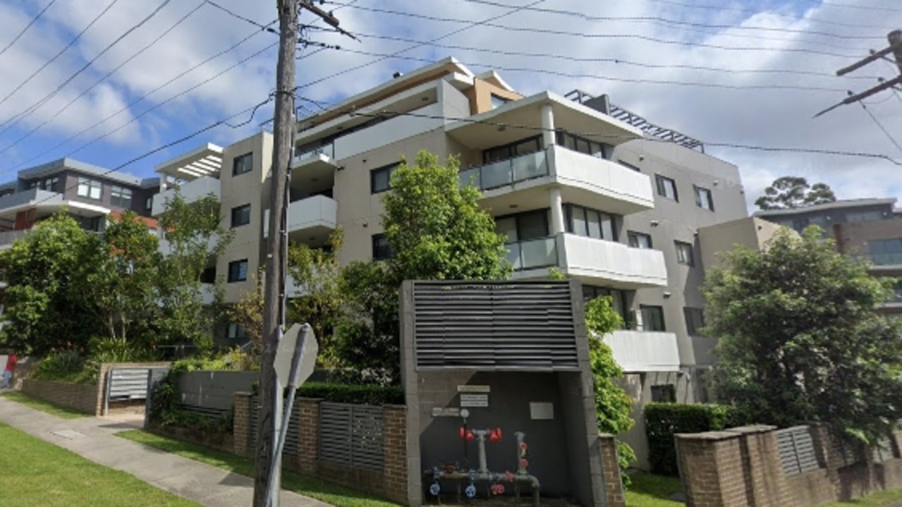
Black mould, cracking allegedly plagues northwest Sydney units
More than a dozen alleged serious defects including mould and water leaks have been found at a northwest Sydney unit block where the owners’ corporation has taken the developer to the NSW Supreme Court.
Read more

‘Worried sick’: Family fears young motorcyclist missing in floods
The family of a young motorcyclist en route for the Newcastle area from Coffs Harbour are pleading for help among fears he may have been caught up in the flood disaster during his road trip home.
Read more

Strict bail conditions for cop accused of accessing restricted data
A NSW police officer accused of accessing restricted data has been ordered not to interfere with prosecution witnesses more than two months after being charged.
Read more

‘Aussie Jews face increasing hostilities from the left’
Australian Jews are facing increasing hostility not just from groups such as neo-Nazis but also from people on the left, a Sydney Writers Festival panel discussing anti-Semitism has heard.
Read more

What wild weather means for Vivid travel plans
Train cancellations, flood-affected roads and landslides have thrown Friday’s Vivid Sydney travel into disarray. Here’s what you need to know before heading into the city.
Read more

Knife’s edge battle for Bradfield down to 4 votes
One of the tightest contests of the federal election has come down to wire with teal Nicolette Boele leading by just four votes.
Read more