Tasmania’s new coastal walk has hikers on the edge all the way
After seven years, the Three Capes Track coastal walk has opened to controversy.

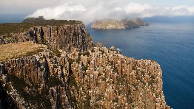
Were it not for the vertigo, I’d feel like a god.
I’m standing on a column of fluted, Jurassic dolerite rock, my head literally in the clouds — or sea fog, at least. Move more than a few centimetres in any of three directions and I face a particularly nasty death: a drop of several hundred metres to jagged rocks and a churning ocean below.
Putting aside giddiness, the sensations experienced here atop The Blade at Cape Pillar, in Tasmania’s Tasman National Park, are exhilaration, wonder and awe; of being perched on the edge — not only of an almighty precipice but of Australia itself.
Adding to an ethereal atmosphere, I can hear the calls of seals and seabirds far below, contorted by the wind and amplified by formidable vertical rock formations to produce a mysterious and haunting symphony.
A white-bellied sea eagle patrols the cliff line, floating effortlessly on the updrafts, waiting to pluck its lunch from sea or stone, as effortlessly and patiently as a diner at a sushi conveyer.
The sea fog is spectral, washing over me and this remarkable landscape in fast-moving waves, by turns hiding and then briefly revealing the sheer drop below as well as the imposing cliffs of Tasman Island about 400m opposite.
Separating Cape Pillar and the island is a strait sometimes referred to by sailors as “the hole in the wall”, providing a portal for vessels to pass from Tasmania’s east coast towards Storm Bay and Hobart’s magnificent Derwent Estuary. South lies nothing but sea — and Antarctica.
A scramble up The Blade is a highlight of Australia’s newest — and possibly greatest — coastal walk: the Three Capes Track, which opened two days before Christmas.
Speak to a local about this monumental project — $28 million and seven years in the making — and you’ll doubtless hear a joke about the “missing” third cape.
The 46km, cliff-hugging, forest and heathland-dissecting track reaches Cape Hauy and Cape Pillar but, because of budget overrun or design rethink (depending on who you believe), never made it, as originally intended, to Cape Raoul.
Despite the derision, the track delivers more than it promises. From The Blade, on a fine day, it is possible to see nine capes. For once, the marketers may have undersold the product.
And a controversial product it is. For hard-core bushwalkers, the three-night, four-day walk is too easy, too commercial and not what trekking in national parks is about.
The track itself — gravel, stone and boardwalk — is about 1m wide and thus dismissed by outdoor types as a “road”. It is designed to allow people to stroll side by side, a rarity for trekkers who normally see as much of their companion’s backpacks as they do of the surrounds.
The three architecturally designed and meticulously constructed cabin sites look more like luxury resorts than the traditional, basic bushwalking huts found on the Overland Track and other treks. Communal dining and living areas include water taps (albeit hand-pumped), recharge stations for smartphones, Tasmanian oak floors, flyscreens, gas stove tops, pellet heaters, timber decks and stunning views.
At Munro cabin site, on the second night, there’s even a shower — a bucket with showerhead attached, hoisted via a pulley system — with a designer shelter of curved, corrugated iron for privacy. (It was cold water only at the time of my visit, but there are plans for a gas heating system.)
The comfortable sleeping cabins are designed to accommodate 48 walkers, the number dispatched from Port Arthur each day.
That may sound a lot, but each cabin accommodates four to eight, allowing families and groups to bunk down in privacy.
Three “host rangers” — a new job category for Tassie’s Parks & Wildlife Service, created for this walk — are stationed at each site, acting as guides, chaperones and de facto hotel managers.
Pots and pans are provided so that all walkers need bring is sufficient food and a sleeping bag; no camp burners, tents or billycans weighing down heavy packs.
Along the walk, stories explaining the area’s fauna, flora, geology, geography and history are revealed via 18 seats, created by University of Tasmania furniture design students, as well as strategically placed quirky artworks and an engaging 85-page glossy colour guide book, provided to all walkers. Combined, they make an innovative alternative to the dull-but-worthy interpretative signs and lifeless books traditionally relied on by trekkers to better understand their surrounds.
“It’s an understanding of the whole environment; the land on which they are standing — it’s one of the things that sets this walk apart from any other,” explains Three Capes project manager Justin Helmich.
All of which, combined with the price tag — $495 or $396 for concession/child tickets — has fuelled talks of elitism; of turning a natural public asset into a plaything for the cashed-up, to the detriment of ordinary folk. The criticism has stung Parks & Wildlife, which is working to provide adequate camping opportunities for independent walkers.
State Parks Minister Matthew Groom is also quick to point out that day walks — to popular spots along the track, such as Cape Hauy, Cape Raoul and Shipstern Bluff — remain free (for those with a normal park entry pass).
There are legitimate concerns around the loss of wilderness values whenever structures are built on virgin bush. But critics of the track should consider that elitism works both ways: why should national parks be kept as the preserve of the fit and time-rich, especially if Australians are to continue to support the creation and maintenance of such reserves?
Parks boss Peter Mooney argues the Three Capes Track opens up bushwalking to a new crowd, with plenty of options remaining elsewhere for the hardcore.
“There is a great proportion of middle-class Australians who are not accessing reserves and not accessing natural experiences,” Mooney explains. “The biggest issue, though, is that Australia is urbanising at a greater rate than ever, so we want to get people back out to the bush. To do that you have to allow them to be confident to go out into the bush, and for it to be at a use level they are comfortable with.
“You can’t covert people (to the outdoors) overnight. This (track) is an entry point for a lot of people to have a fantastic experience in a natural area but not feel uncomfortable or nervous.
“It might actually create a spark for them to further their adventures in national parks.”
With thousands — from preschoolers to octogenarians — booked for the track in its first summer, Australians appear to voting with their walking boots.
WHAT TO EXPECT
DAY ONE
Port Arthur to Surveyors
1h 15m hour boat cruise; 4km (1.5-2h) walk
Eco-cruise boat trip from Port Arthur Historic Site to walk starting point at sandy Denmans Cove, taking in Safety Cove and Crescent Bay (and possibly the odd dolphin or seal). A two-hour walk through eucalypt woodlands and coastal heathland. Overnight at Surveyors cabin, just south of Surveyors Cove, 120m above sea level at the edge of a buttongrass plain, with sunset views from a deck to Cape Raoul.
DAY TWO
Surveyors to Munro
11km, 4-4.5h walk.
Gentle climb up Arthurs Peak, with views over the perfectly shaped, sandy Crescent Bay and Mount Brown to Cape Raoul.
Cliff-top stroll through forest and on to the coastal heath of Ellarwey (short for “Where the hell are we”) Valley before entering a stand of tall eucalypts, across Tornado Flat to Munro. Spectacular views (from a catwalk-shaped deck) of the cliffs of Munro Bight and out towards Cape Hauy. Shower available.
DAY THREE
Munro to Retakunna, via The Blade
17km (5h) walk
Walk south to some of Australia’s southernmost points and dizzying cliff tops to Cape Pillar and the 262m high The Blade. Dramatic 360-degree views — on a fine day — south to the steep grey basalt face of Tasman Island and of up to nine capes in the other directions. Retrace your steps to Munro before heading north to Retakunna, at the foot of Mount Fortescue, with sunset views of Cape Pillar.
DAY FOUR
Retakunna to Port Arthur, via Cape Hauy, Fortescue Bay
14km (4.5-5h) walk.
Gently contoured ascent of Mount Fortescue (482m) via rainforest, then a gentle downhill trek through mixed forest and eucalypt woodlands to the fluted cliffs of Cape Hauy, and offshore rock needles, such as the Totem Pole. Further downhill run through coastal heathland to the white sands of Fortescue Bay and a cooling swim. Bus back to Port Arthur (a variety of transport options available to and from this end point, although many will want to stay on to explore the historic site and broader Tasman Peninsula).
Matthew Denholm received a preview of the the track courtesy of the Tasmanian government.
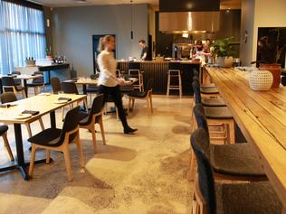
Working up an appetite
There were restaurants that worked, and others that didn’t. What should diners expect in 2017?
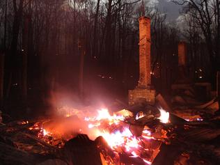
Following Bonnie into the fire
Save for his faithful companion Bonnie, John Laffan would have perished in the Black Saturday bushfires.