Wild weather: Power cuts, flooding, wind damage as Antarctic blast menaces NSW, Vic and Tasmania
Wild, wintry weather is menacing three states. And the cold front chaos will get worse tomorrow.
Eastern Australia is shivering through an Antarctic blast which has dumped rain and snow, cut power, and seen blizzards in the high country as temperatures plummet.
Wild winds tearing through Tasmania and Victoria overnight saw trees brought down, and power cuts in the island state.
🌊 Large areas of the southeast coast can expect dangerous surf conditions with large swells today and into the weekend—swell heights well above 6 metres. For all national warnings: https://t.co/zZAdUesZic. @SLSAustralia pic.twitter.com/zblj9hlOg4
— Bureau of Meteorology, Australia (@BOM_au) July 11, 2019
The damaging winds are now menacing NSW, with thousands of homes and businesses around NSW without power as damaging winds whip parts of the state.
Another wave of cold front conditions on Friday will see the wild, chilly conditions continue well into the weekend, with snow-lovers perhaps the only ones happy about the forecast, which includes heavy snow and more blizzards.
Along the coast, huge swells are likely to stay well above six metres — and even up to eight metres — into the weekend.
With another cold front on the way, strong winds are set to continue helping to bring large waves 🌊 and swell to #Victorian waters. Significant wave heights over 8 metres are forecast offshore of the southwest coast from late Friday! https://t.co/v5dNNh8ymo pic.twitter.com/u96IfnqhFK
— Bureau of Meteorology, Victoria (@BOM_Vic) July 11, 2019
NSW
A cold front began moving across southern NSW early today, with gusts of more than 100km/h recorded in some areas including Thredbo and Cooma.
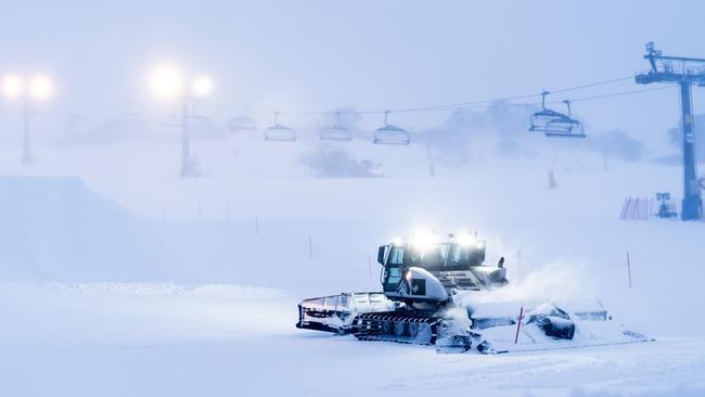
Blizzards have already dumped more than 20cm of snow at NSW ski resorts.
The Bureau of Meteorology has issued a severe weather warning for the Illawarra, Snowy Mountains, and sections of the South Coast and Central Tablelands. A second cold front is expected to cross NSW on Friday and Saturday. The strong winds have already brought down trees and branches over powerlines.
Endeavour Energy said it was working to restore power to nearly 3700 properties across the Southern Highlands, Blue Mountains and South Coast. Almost 100 electrical hazards have been reported since the early hours of this morning, with crews patrolling those areas to ensure safety. Meanwhile, fishers and boaties are being told to be extra cautious with a strong marine warning in place along the NSW coastline.
Road and Maritime Services are urging people to take extra care on the water and be aware of hypothermia.
🚨Dump Alert🚨 20cm fresh snow overnight & still coming down! â„ï¸ Blizzard conditions with further snowfall, cold temps and strong winds continuing today. pic.twitter.com/R5tdXTOZaa
— Perisher Ski Resort (@PerisherResort) July 10, 2019
Choppy conditions are expected on exposed bays as well as dangerously rough conditions offshore and there’s a risk of boats dragging or breaking free from moorings, the RMS said.
Rock fishers have also been urged to check weather forecasts, avoid fishing near dangerous surf and wear life jackets.
Conditions are expected to ease on Sunday but there may be an increase in ocean swell.
Victoria
A severe weather warning remains in place for parts of Victoria after a night of wild winds saw hundreds of calls to the SES — mainly for downed trees.
The next cold front will hit on Friday, bringing more rain, storms, winds, snow and possible hail. The forecast is similar for Saturday.
It’s the same wild weather which on Thursday night saw wind gusts of up to 124km/h were recorded at Mt Hotham and 119km/h at Mt William.
Closer to the city, Port Phillip Bay had winds of up to 100km/h and Moorabbin Airport 87km/h.
Meanwhile in Melbourne, water gushing from a burst water main forced the closure of a Melbourne CBD thoroughfare for most of the day.

Commuters were advised to take alternative routes with Victoria Street closed between Swanston St and Elizabeth St.
VicRoads spokesman Chris Miller said the intersection was likely to be closed for the rest of the day as authorities cleaned up the water.
The closure would likely remain throughout afternoon peak traffic, he said: “Obviously that is causing some headaches, there’s no really easy way around it.”
That front packed a punch, with rain across #Victoria and isolated storms and damaging winds💨 Strongest gust of 124km/h at Mt Hotham with 106km/h at Horsham. Around #Melbourne we had 98km/h over the bay https://t.co/jZGefYtmBq pic.twitter.com/Nk0AOHgtTq
— Bureau of Meteorology, Victoria (@BOM_Vic) July 10, 2019
A severe weather warning for damaging winds remains in place today for parts of Victoria.
A blizzard warning is also likely, with up to 50cm of snow predicted to fall on Friday.
As winds ease, the Bureau of Meteorology senior meteorologist Rod Dickson predicts temperatures will drop.
“Even though the temperature remains in the teens the wind chill is going to be quite significant, so it will feel significantly cooler,” he said.
“We may even see some snow about the peaks of Mount Dandenong.”
Tasmania
Around 1800 properties in Tasmania’s north and northwest have been left without power after wild winds lashed the state overnight.
A severe weather warning for damaging winds is in place for the state’s southeast, including Hobart, west, north and Bass Strait islands. The worst affected area is north of Launceston, with more than 500 properties without power on Thursday morning.
Low Head, north of Launceston, had gusts of up to 95km/h.
Tasmania Police received about 30 weather-related call-outs overnight.
The Bureau of Meteorology has issued a minor flood warning for the Meander, Mersey and North Esk rivers.
Damaging winds, averaging 60 to 80km/h with peak gusts more than 100km/h are likely in the west and north this afternoon before extending south on Friday.
with AAP
‘Holy grail’ fish discovery comes with one big catch
The discovery of a rare, untapped, abundant and delicious food source off Australia’s southern coast is quickly shaping as an unsavoury battle.
Marles pays US an AUKUS advance
Australia has made its first AUKUS down payment to the US as the Albanese government looks to lock-in Trump administration support for the submarine program.