The first cyclone of the season is threatening a vast reach of coastal Queensland, potentially with catastrophic Category four destructive winds
A severe tropical cyclone is brewing off the coast of Queensland, with residents in the firing line urged to prepare.
The first cyclone of the season is threatening a vast reach of coastal Queensland, potentially with catastrophic Category four force packing destructive winds of up to 280 km/hr.
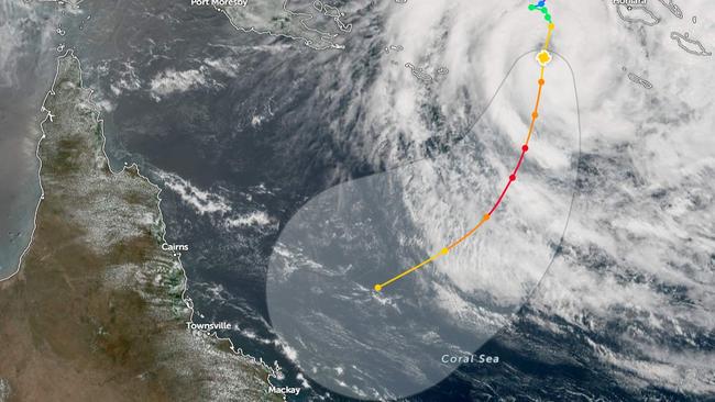
Tropical Cyclone Jasper, situated near the Solomon Islands, has intensified to Category three, according to the Bureau of Meteorology (BOM).
The Bureau predicts Jasper will strengthen further into a category four cyclone on Thursday, possibly turning into a category five by Thursday night.
“It’s forecast to reach high end category 4 intensity later Thursday and possibly category 5 on Thursday night,” BOM said.
Senior forecaster for the Bureau Laura Boekel said the cyclone’s trajectory indicated it would make landfall in regions north of Mackay early next week.
Over the weekend, Jasper is likely to weaken but will remain as a Tropical Cyclone.
Ms Boekel said it was rare to see a tropical cyclone near Queensland so early in the summer, especially during El Nino.
“We typically see fewer cyclones and we also see the cyclone season starting a bit later,” she said.
“So to see this earlier in the season and in December during an El Nino year is unusual.”
Residents in the potential impact zone are advised to stay vigilant, heed official warnings, and to prepare for the potential arrival of Cyclone Jasper early next week.
Jasper is moving at 11km/hr, with winds near the centre at 165km/hr and wind gusts of up to 120km/hr.
“The Bureau will issue a Watch Alert when Tropical Cyclone Jasper is 24-48 hours from making landfall.” Laura Boekel said.
The alert system aims to provide residents with sufficient time to prepare and take necessary precautions before the arrival of the cyclone.
Ms. Boekel said conditions could lead to a cyclone alert being issued as early as this weekend.
“It’s difficult to commit to, but in terms of (time) windows, probably late weekend, early next week, we can potentially start to see watches, but if something happens and it really pushes this thing towards the coast, of course, that (alert) could come sooner.”
Anticipated to reach a severe Category three cyclone by Wednesday night and escalate to a Category four by Friday, Ms. Boekel said the system’s intensity may not “necessarily correlate with higher levels of rainfall.”
Queensland river catchments are relatively dry and may take some time to fill in northern areas if flash flooding occurs.
“The intensity doesn’t necessarily correlate to the amount of rainfall so we could see a lower intensity cyclone and still see a lot of rainfall,” She said.
The Bureau will provide regular updates on the cyclone’s progress, including any changes in its projected path or intensity.
Cyclone Seth was the last tropical cyclone to hit Queensland in 2021, bringing widespread flooding to several towns in the state.

‘Unique’ AUKUS deal earns Trump approval
President Donald Trump has flagged his support for the complex defence arrangement with Australia after the Albanese government delivered a $798m payment.

Found: rock legend’s ‘lost’ songs
People are strange, The Doors told us, but no stranger than the tale of Jim Morrison’s ‘lost’ songs, believed to have turned up in a cluttered timber home on a remote hill in the Tasmanian bush.