NSW weather: Warragamba spills, bride-to-be watches home wash away, ‘mini tornado’ hits Chester Hill
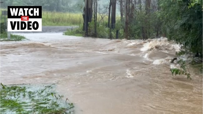
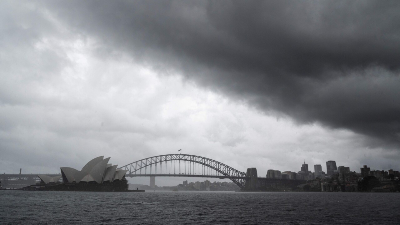
Sydney’s main water source, the Warragamba Dam, has begun to overflow after a mini cyclone battered parts of Sydney’s south west.
- Rainfall records tumble
- Fresh evacuation orders issued
- One metre of rain as twin systems link up
- Golden Slipper postponed
- Fears for missing woman, dam to burst
- Mini tornodo hits Sydney’s west
- Warragamba Dam begins to spill
- Flood claims couple’s house...and wedding day
That concludes today’s live coverage of the unfolding flood emergency in NSW. Here is the latest:
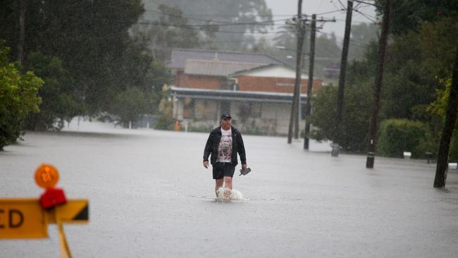
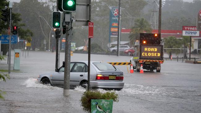
People in a number of low-lying areas along the New South Wales coast have been urged to evacuate as record-breaking rains and raging floodwaters threaten homes and lives.
A severe weather warning remains active on Saturday for people in the Hunter, Sydney, Illawarra, and Southern Tablelands districts, as well as the Australian Capital Territory and parts of the Mid-West Slopes and Snowy Mountains districts.
Authorities are urging all residents in high flood zones to prepare for the possibility of evacuation.
Warragamba dam has started to spill. With heavy rainfall persisting, we are also expecting to see spills at Nepean, Cataract, Cordeaux and Avon dams.
— WaterNSW (@WaterNSW) March 20, 2021
For weather forecasts and flood warnings, visit https://t.co/2GW553xMtn
For emergency information, visit https://t.co/7v9ukIZgQBpic.twitter.com/eainGUuCaw
Nine evacuation centres have been established across the state, with the Hawkesbury river, Warragamba Dam and Nepean flood plains on “high alert” evacuation watch.
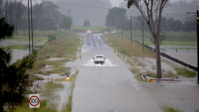
The Warragamba Dam, Sydney’s major water source, has begun spilling over after reaching capacity on Saturday afternoon.
The State Emergency Services expects flooding in the Sydney region’s of Penrith and Richmond
Mid North Coast and Central Coast and the Hunter Region are also on high flood watch.
The state’s emergency services said the deluge is making its way down to the Illawarra region.
NSW Premier Gladys Berejiklian on Saturday said “it will not be an easy week” for the state, with the onslaught of wet weather expected for the most part of the week to come.
“I hate to say this again to all our citizens of the state but it’s not going to be an easy week for us, but I know no matter what comes our way we will be able to deal with it,” Ms Berejiklian said
“Unfortunately this will be a deep-seated, extreme weather event.
“The rain may not stop till Thursday or Friday.”
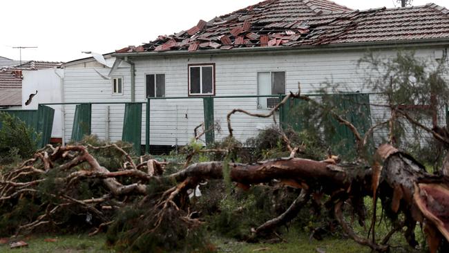
A mini tornado was also sighted at Chester Hill and impacted three streets.
Emergency services minister, David Elliott said: “It is very important that you monitor the SES website and the evacuation warnings, it‘s no good preparing to evacuate after you have received an evacuation warning”.
As rain fell across the state on Saturday, footage from the NSW mid-north coast has shown flood waters sweeping away homes in dangerous rapids.
Footage from Taree local Ciara Knox shows the “heartbreaking” moment a home is destroyed
by the forces of the Manning River.
Incredible, but devastating footage of a house floating down the Manning River at Taree.🎥Tanya Cross #NSWfloodspic.twitter.com/KTggPpvlWO
— Claudia Jambor (@claudiajambor) March 20, 2021
The home belonged to Sarah Soars and her fiance Joshua Edge who had planned to marry on Saturday.
A shattered Sarah Soars told The Mid-North Coast News that she couldn’t believe her eyes when from a lookout — high above the Manning River — she spotted the house and all their possessions capsizing into the water about 9.30am.

Hundreds of millimetres of rain have already fallen on parts of NSW since Friday, and forecasters warn there is more to come.
Between 9am Friday and 5am Saturday, Delward recorded 373mm of rain, Redoak received 343mm, and Upper Rollands Plains recorded 250mm; including 125.8mm in three hours.
Up to 120mm could fall in Sydney on Saturday.
The Hawkesbury River at Windsor, NW of Sydney is rising.
— Josh Bavas (@JoshBavas) March 20, 2021
You can see how it’s about to swamp the old bridge, compared to the new one. pic.twitter.com/JKRVtX4weB
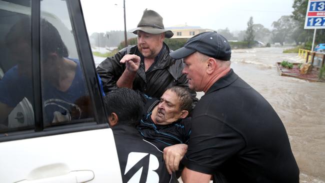
The SES confirmed there has been 4000 call outs and 500 direct rescues already.
The Bureau of Meteorology’s NSW and ACT manager Jane Golding warned the conditions were “dangerous” and could change “quite quickly”.
“If you don’t need to travel, if you don’t need to head out today, this is the day to really stay home,” Ms Golding said.
“For some areas that do have evacuation orders, of course, making sure that you follow advice from emergency services and stay clear of any dangerous areas and conditions.’
Ms Golding said more rainfall was possible over the Mid North Coast on Saturday evening and into Sunday.
“The flood risks will remain,” she said.
“We are seeing rainfall that is record-breaking for March, by 100-200mm above those March records.
“This is a very significant, record-breaking event with the heaviest rainfall that we have seen.”
Commonwealth Bank and ANZ have announced emergency relief to customers affected by flooding, with assistance including customised repayment arrangements and temporary overdrafts.
The Westpac group, which includes St George Bank has also implemented similar measures.
As of 6.30pm on Saturday, the Bureau had issued a number of flood warnings;
-Major flood warning for the Hastings River, as major flooding occurs at Kindee Bridge, Wauchope and Settlement Point
-Major flood warning for the Manning River at Taree with levels forecast to reach 5.8m, just below the 1929 record of 6m
-Major flood warning for the Hawkesbury, Nepean and Colo Rivers, with major flooding possible at North Richmond, Windsor and Sackville, and moderate flooding at Menangle, Wallacia, Penrith, Portland and Wisemans Ferry.
-Minor flood warning for the Georges River, with possible flooding to occur in low lying parts of Liverpool.
-Minor flood warning for the Nambucca River, as renewed rises are possible at Macksville
Moderate flood warnings for the Macleay River, as moderate flooding occurs at Kempsey and Smithtown.
-Minor flood warning for the Orara River at Glenreagh and Coutts Crossing
-Minor flood warning for the Bellinger River, with minor flooding occurs at Thora
-Minor flood warning for the Myall River, as minor flooding occurs at Bulahdelah
-Minor flood warning for the Deua River at Wamban, with an expected peak of 4 metres.
-Minor flooding along the Tuggerah Lake.
Southern parts of Queensland are also set to receive more rain on Saturday, with up to 100mm possible for the Gold Coast.
Evacuation orders current as of Saturday 6.30pm:
-Central Wingham and the Wingham Peninsular
-Taree Estate, Dumaresq Island and Cundletown
-Laurieton, North Haven, Dunbogan and Diamond Head
-Kings Point and Macksville
-Wauchope and Rawdon Island
-Bulahdelah
-Kempsey CBD
-Lower Macleay
-Port Macquarie
-Evacuation warning for Picton CBD.
Dan Mills8.30pm:Flood claims couple’s house...and their wedding day
A shocked bride-to-be has recounted the moment she and her fiancee were forced to call off their wedding on Saturday when she saw their house crumbling into the Manning River at Mondrook, near Taree.
Sarah Soars, 24, and Joshua Edge, 26, were dealt the cruellest of blows when floodwaters savaged their Mondrook rental, and washed it away downstream.
A shattered Sarah Soars told The Mid-North Coast News that she couldn’t believe her eyes when from a lookout — high above the Manning River — she spotted the house and all their possessions capsizing into the water about 9.30am.
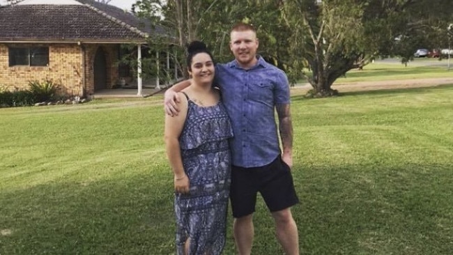
I was up at the lookout at Taree West near where my younger sister lives for maybe 15 minutes before it started to move … I thought, ‘Oh no, this can’t be happening’.”
“Next minute, the house was gone.”
It was the start of the end of her massive plans. Ms Soars was to marry her fiance Joshua Edge in front of 60 family and friends at Mondrook Hall.
She said more than $100,000 worth of prized possessions are now gone, either floating somewhere along the Manning River, out at sea or sitting in floodwaters at home.
“Someone has found my partner’s big wooden chest, though, which washed up somewhere with a bunch of valuables in it,” she said.
“But we’ll have to start again with everything, even our clothes.”
A GoFundMe page has been set up to support the couple, who lived in the home.
More than $33,000 has been donated so far. To contribute click here.
Charis Chang8.00pm:Couple separated by floodwaters on wedding day
A bride has been left devastated after floodwaters trapped her at a riverside farmhouse, separating her from her fiance on their wedding day.
Taree nurse Anya Kerrigen and her fiance James Farrawell planned to marry on Saturday after saving for their dream wedding for three years.
But the bride and about 27 members of her family and friends are trapped at their wedding venue, in a picturesque riverside farmhouse, while the groom and his groomsmen are just 50 minutes drive away in Taree, unable to join them due to road closures after the Manning River flooded.

The groom’s brother Daniel Farrawell told news.com.au that family members including grandparents had spent the night in flooded glamping tents and a farmhouse.
“The bride and both sides of the family spent the night without electricity,” he said.
In a devastating twist of fate, the groom had decided to return to Taree last night to honour the tradition of a couple not spending the night before their wedding together.
“The groom has been trying to marry the bride for years and between COVID and this flood it proves that the best things in life don’t always come easy,” Mr Farrawell said.
“Without a helicopter this wedding over and done for.”
Carla Mascarenhas 7.30pm:‘Next couple of days crucial’: Farmer
Belmore River dairy farmer Sue McGinn said farmers will be praying for sunshine on the NSW Mid North Coast.
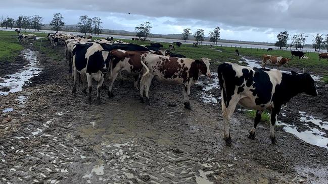
“This time of year we should be planting our winter ryegrass pastures so that they are established before the weather cools off,” she said.
“Once the flood waters recede we will have to wait for the land to dry out before we can sow seed. More rain is the worst possible scenario. While we always welcome rain, a flood can be damaging and the next couple of days will be telling.”
Ellen Ransley7.00pm:BOM’s latest flood warnings
As of 6.30pm on Saturday, the Bureau had issued a number of flood warnings;
-Major flood warning for the Hastings River, as major flooding occurs at Kindee Bridge, Wauchope and Settlement Point
-Major flood warning for the Manning River at Taree with levels forecast to reach 5.8m, just below the 1929 record of 6m
-Major flood warning for the Hawkesbury, Nepean and Colo Rivers, with major flooding possible at North Richmond, Windsor and Sackville, and moderate flooding at Menangle, Wallacia, Penrith, Portland and Wisemans Ferry.
-Minor flood warning for the Georges River, with possible flooding to occur in low lying parts of Liverpool.
-Minor flood warning for the Nambucca River, as renewed rises are possible at Macksville
Moderate flood warnings for the Macleay River, as moderate flooding occurs at Kempsey and Smithtown.
-Minor flood warning for the Orara River at Glenreagh and Coutts Crossing
-Minor flood warning for the Bellinger River, with minor flooding occurs at Thora
-Minor flood warning for the Myall River, as minor flooding occurs at Bulahdelah
-Minor flood warning for the Deua River at Wamban, with an expected peak of 4 metres.
-Minor flooding along the Tuggerah Lake.
Nicholas Jensen6.30pm:Warragamba Dam begins to spill
Sydney’s main water source, the Warragamba Dam, has begun to overflow as heavy rainfall continues to lash Sydney’s outer west.
Earlier today, the Bureau of Meteorology’s (BOM) Flood Operations Manager Justin Robinson said “the exact timing of the flooding depends on which areas of the catchment receive the heaviest rainfall and the time in which they receive that rainfall,” he said.
According to the BOM, the dam had reached 99.2 per cent capacity earlier in the afternoon, with the spillage expected to begin within the next 24 hours.
Sydney's main supply dam, #WarragambaDam has reached capacity and has begun spilling. pic.twitter.com/tIypMwkFmz
— Benjamin Ansell (@averagejourno) March 20, 2021
Spill from the dam is expected to combine with river flows from the Upper Nepean and the Grose River, as well as other local tributaries, including South Creek.
NSW Premier Gladys Berejiklian said emergency services were preparing for either “a one-in-five, one-in-10 or one-in-20 year event”.
She has urged residents in the catchment area to be on high alert in case they were required to evacuate.
Nicholas Jensen6.10pm:Vaccine rollout delayed because of ‘extreme’ rain
As the state’s weather emergency continues to unfold, the federal government has confirmed conditions will delay Monday’s vaccine rollout.
This afternoon the Department of Health warned that flash flooding would delay the distribution of vaccines across the state, with regional NSW particularly affected.
A spokeswoman for the government said that “vaccines are being delivered across the country and will be in place in most locations by the end of the weekend.”
However, due to the extreme weather conditions and flooding in many parts of the state, “vaccine delivery is being affected in Sydney and across multiple regional NSW locations.”
“The Department of Health is working directly with GPs on these issues and we ask for the public’s patience with these unforeseen supply delays.”
Phase 1b of the vaccine rollout is set to begin on Monday, with the first locally produced shipment of AstraZeneca expected to be delivered across the country at the beginning of next week.
Health officials have said they will provide an update tomorrow concerning which areas will be particularly affected.
Carla Mascarenhas5.30pm:House floating down river belonged to couple set to wed
A house that has been swept away in floods near Taree belonged to a young couple who were due to get married today, according to multiple reports.
The home was filmed being dragged through raging flood waters on the Manning River, near the Mid North Coast town..
A GoFundMe page has been set up to support the couple, who lived in the home.
“On 20th March our brother Joshua and his fiancé Sarah lost their entire home and belongings to the flood waters in Mondrook nsw on the mid north coast,” Lyle Edge wrote.
“What was supposed to be their wedding day ended up with their house floating down river and them losing everything they have worked hard for and sadly losing their pets as well. We are trying to raise money to help them start again.”
More than $22,000 has been donated. To contribute click here.
The couple is being sought for comment.
Nicholas Jensen5.00pm:‘Flooding coming at us from different angles’
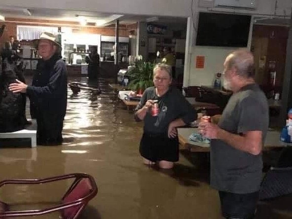
Major flooding from the Manning River has inundated Taree on the state’s Mid North Coast, with heavy rain continuing to fall across the region.
Club Taree president, Paul Allen, who is managing the evacuation centre told Sky News: “I’ve never seen it this bad and we’ve got many residents here on site, some well into their eighties and nineties, who’ve never seen this before.”
“The flooding seems to be coming at us from different angles… the water looks a kilometer wide in some places which is amazing”
Asked whether people were cooperating with emergency services and observing advice, Mr Allen said: “We’re in contact with emergency services on a regular basis and the majority of people are doing the right thing which is stay away and get out.”
“We’re receiving calls, we’re getting people coming down to see how they can help... like any other country town we are rallying together as a team.”
Carla Mascarenhas4.45pm:Tragic footage of house floating down Manning River
Tragic footage shows a couple’s home being swept away in floods near Taree.
The home was filmed being dragged in flood waters on the Manning River near the mid north coast town.
A video shared by Tanya Cross from Taree showed the house being swept down the river. “Heartbreaking,” she wrote sharing the shocking footage.
A GoFundMe has been set up to support the couple, Josh and Sarah, who lived in the home. It is understood the couple were to get married today.
Incredible, but devastating footage of a house floating down the Manning River at Taree.🎥Tanya Cross #NSWfloodspic.twitter.com/KTggPpvlWO
— Claudia Jambor (@claudiajambor) March 20, 2021
Carla Mascarenhas4.20pm:‘I’ve never seen anything like this’: Port Macquarie resident
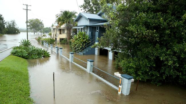
More images are emerging of the Port Macquarie CBD, where floodwaters have left the CBD completely underwater.
Dozens of shops are inundated as well as as a parked car which looks like it’s staying there for a while.
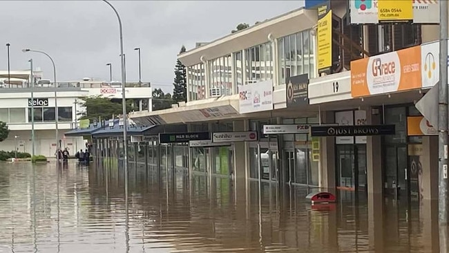
“It has been pretty horrendous,” resident Robyn Ryan said. “I have been here since 1979 and I have never seen anything like this.
“Parts of the CBD are flooded and it is tragic for the businesses involved. We have had a terrible 12 months with bushfires, Covid and now floods. What’s next?”
Denise Smith from Telegraph Point, 16km north of Port Macquarie, said the village is without power and the water is 1m up from the ground.
“Everywhere you look the paddocks are just flooded,” she said. “There is a going to be a huge clean up after this. Just over a year ago we were watching a fire come up over the back fence.”
Nicholas Jensen3.33pm:‘Mini tornado’ hits Sydney’s west
Locals are mopping up after a ‘mini tornado’ lashed Chester Hill, in Sydney’s west, on Saturday morning.
Roofs were damages, trees were felled and about a thousand people have been left without power after the tornado struck about 9am.
SES Commissioner Carelene York said crews were “still assisting the community and making sure Chester Hill is safe”.
Acknowledging it was an unusual event, she warned “it doesn’t mean that it can’t happen again... It’s very difficult to prepare for such a significant weather event”.
Premier Gladys Berejiklian said: “Unfortunately this will be a deep-seated, extreme weather event until towards the end of next week.
“We hope those predictions are wrong.
“The message is very clear: Do not walk-through or drive through floodwaters, do not drive over water that is covering a road.”
Chester Hill in western Sydney. It’s like someone picked up the neighbourhood and rotated it to one side 📸: @FRNSWpic.twitter.com/2iHRhL6cIE
— Gavin Coote (@GavinCoote) March 20, 2021
Nicholas Jensen3.22pm:It’s not going to be an easy week: Premier
NSW Premier Gladys Berejiklian has provided an update on the state’s weather emergency, saying “the best prediction we have is that this will be a prolonged weather event”.
The Premier said the potential spillover of the Warragamba Dam continued to be closely monitored by the SES, as she urged residents across the central coast, metropolitan Sydney and the catchment of the Warragamba Dam to stay on high alert.
“I’ve received a briefing from our SES experts, in relation to a potential for one in five, or a one in 10 or one in 20 event… all three scenarios are being planned for.
“I hate to say this again to all our citizens but it’s not going to be an easy week for us,” Ms Berejiklian said.
Minister for Emergency Services David Elliot criticised early responses to the emergency, saying “while we can’t control the weather, we can control our behaviour.”
“Five hundred flood rescues over the course of this operation so far, is just completely unacceptable... That’s 500 specialist SES crews that have put their lives at risk because people have not heeded the warnings.”
Frustrated with the lack of compliance, Mr Elliot said: “It appears every time we get that message out within hours there’s another half-dozen flood rescues.
SES Commissioner Carlene York said services had been very active over the last 24 hours responding to a surge of flood rescue cases.
“This is a slow moving event that is why it’s such a risk. Often events (like this), pass through a small peak and start to go away, that is not the circumstances for this event... the rain will continue towards the end of next week.”
Asked about the availability and supply of resources in affected areas, Commissioner York said “We are reaching out to other states to send some skilled personnel, such as flood rescue technicians… I know our members are working very hard.”
Nicholas Jensen3pm:Tropical thunderstorms the next challenge
As torrential rain and flash flooding continues to pummel coastal NSW, the Bureau Of Meteorology (BOM) says we can expect conditions to fluctuate into the beginning of next week, with models suggesting that river levels could “reinvigorate” by next Tuesday.
By Monday, a major band of thunderstorms is predicted to push down from the tropics, with northern South Australia, Southern Queensland and northern NSW in the firing line.
A spokesman for the BOM said this system will merge with the current coastal trough “in a burst of very heavy rain that will move into eastern New South Wales during Tuesday”.
By Tuesday night, forecast models suggest widespread totals of 100 to 200 mm of rain, with some higher isolated totals reaching up to 500mm in addition to what has already fallen.
This scenario, the BOM warns, “could reinvigorate river levels”.
The critical time for Sydney will be later on Saturday afternoon and into the evening, with the potential for flash flooding and widespread disruptions,” the spokesman said.
As well as the Warragamba Dam, the Hawkesbury and Payne rivers are also expected to “reach a major level over the weekend”.
“It’s going to be a wet and potentially dangerous couple of days for eastern NSW.”
Ellen Ransley2.35pm:BoM’s latest flood warnings
As of 1.30pm on Saturday the Bureau had issued a number of flood warnings;
- Major flood warning for the Hastings River, as major flooding occurs at Kindee Bridge, Wauchope and Settlement Point
- Major flood warning for the Manning River at Taree with levels forecast to reach 5.8m, just below the 1929 record of 6m
- Major flood warning for the Hawkesbury, Nepean and Colo Rivers, with major flooding possible at North Richmond, Windsor and Sackville, and moderate flooding at Menangle, Wallacia, Penrith, Portland and Wisemans Ferry.
- Moderate flood warning for the Nambucca River, as major flooding occurs at Bowraville and Macksville
- Moderate flood warnings for the Macleay River, as moderate flooding occurs at Kempsey and Smithtown.
- Minor flood warning for the Orara River at Glenreagh and Coutts Crossing
- Minor flood warning for the Bellinger River, with minor flooding occurs at Thora
- Minor flood warning for the Myall River, as minor flooding occurs at Bulahdelah
Ellen Ransley2pm:Wild weather traps kids at school
A number of primary school students in regional NSW have spent the night in the school library and face a weekend in classrooms after their parents were cut off from Friday afternoon pick-up by floodwaters.
Students and 13 teachers at Kendall Public School unexpectedly did not go home on Friday night as heavy rain triggered “life-threatening” flooding across the NSW mid-north coast.
More than 400mm of rain has been recorded in Kendall, the record heaviest fall for the small town situated south of Port Macquarie.
A major flood warning is active for the Camden Haven River and the nearby town of Laurieton is experiencing flooding worse than its 1978 record.
And the rain keeps on coming ... Our beautiful farm going under. Keep safe everyone & hope all the farm animals & wildlife make it to higher ground #NSWFloodingpic.twitter.com/G5GQOg5O9d
— Anita Jacoby AM (@Anita_Jacoby) March 19, 2021
The rain is expected to continue into the weekend, the Bureau of Meteorology has warned.
Kendall Public parents were alerted around lunchtime on Friday of the worsening conditions and asked to collect their children if they could.
But some roads had already been cut off, making it impossible for some parents to get to the school.
The school’s principal, Alison Jenner, took to Facebook to comfort parents, telling them their children would be looked after by staff.
Phones have remained open throughout the night for worried parents to contact their children.
Some parents of children not at the school have joked about how “jealous” their children are of missing out on the sleepover “adventure.”
On Saturday morning, Ms Jenner wrote there were “lots of hungry little bellies this morning as everyone woke up after a settled quiet night”.
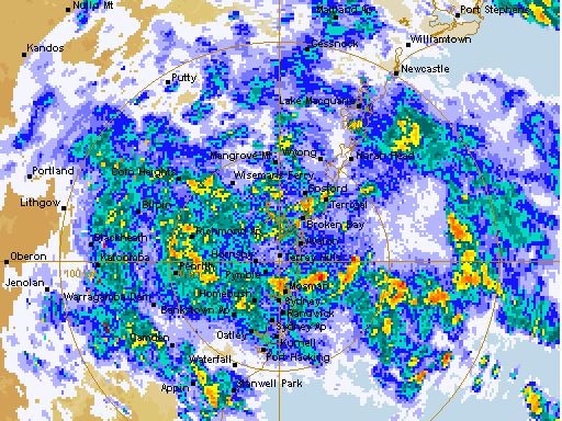
Severe Weather Update: Heavy rain and major flooding for eastern NSW. Current at 11.30am AEDT 20 March, 2021.
— Bureau of Meteorology, New South Wales (@BOM_NSW) March 20, 2021
For the latest forecasts and warnings, go to our website https://t.co/k6eQZdtlhP or the #BOMWeather​​ app and follow the advice of emergency services. pic.twitter.com/lc151ftIdf
Nicholas Jensen1.21pm:Warragamba Dam to overflow this afternoon
Sydney’s main water source, the Warragamba Dam, is expected to overflow for the first time in five years as heavy rainfall continues throughout the afternoon and into the evening.
Bureau of Meteorology Flood Operations Manager Justin Robinson said: “We’re expecting the Warragamba Dam to spill this afternoon and this will then combine with river flows from the Upper Nepean and also the Grose River and the other local tributaries, including South Creek.”
Mr Robinson said once the dam begins to overflow it could lead to flooding in Sydney’s west, particularly around Penrith and North Richmond. He warned it could develop into major flooding overnight as river levels rise.
Crazy photos from Port Macquarie. This is five minutes from my sisters dorm room. #NSWfloods#PortMacquariepic.twitter.com/MQz2QKGwhs
— Emily Kowal (@KowalEmily) March 20, 2021
“The exact timing of the flooding depends on which areas of the catchment receive the heaviest rainfall and the time in which they receive that rainfall.
“It’s a very dynamic and evolving flood situation and we could see some very deep and rapid responding rivers with very high levels.”
He said the dam had not overflowed since 2016.
Drawing a comparison to last February’s floods, the BoM said heavy rainfall predictions for the lower Blue Mountains could also contribute to the escalating situation.
The area is expected to measure 100mm of rain this afternoon, which could increase to 200-300mm.
The BoM has reported that the dam reached 99 per cent capacity earlier this afternoon.
Spill from the dam is expected to combine with river flows from the Upper Nepean and the Grose River, as well as other local tributaries, including South Creek.
Wally Mason 1.10pm:A-League, W-Leauge postponed over weather
A-League and W-League games scheduled to be played in Sydney on Saturday afternoon have been postponed because of the to torrential rain in the city.
The matches between Sydney FC and Melbourne Victory were called off because the surface at Jubilee Stadium in the suburb of Kogarah is waterlogged.
Sydney FC chief executive Danny Townsend said players would be at risk if the games went ahead.
“As a spectacle for our Members and all football fans, any game played on the pitch in its current condition would not be satisfactory, particularly with the standards the A-League and Westfield W-Leagues have set this season. There is also the issue of player safety to consider,” Mr Townsend said.
Nicholas Jensen 12.40pm: ‘A significant, record breaking event’
The Bureau Of Meteorology says conditions across some regions of the mid North Coast remain “life threatening”, with the current weather system producing record breaking levels of rainfall for March - in some cases exceeding historic records by 100-200mm.
In this afternoon’s press conference, senior climatologist Agata Imielska said these were unprecedented events: “We have seen 405mm of rain recorded at Kendall - that’s a record for the heaviest rainfall we’ve seen (in March) - and also 371mm at Red Oak.
“This is not about the amount of rainfall, it’s also how quickly and intensely that rainfall has actually fallen… We had 160mm fall in just three hours at Kindie Bridge. That resulted in also a record river height.”
For the Greater Sydney region, Ms Imielska said “we are looking at widespread rainfall totals across the region of around 100mm. But the heaviest falls are expected over the lower Blue Mountains where we are likely to see 200-300mm.”
While rainfall has eased in parts of the mid North Coast, the BoM has warned there remains a possibility of “reinvigorating rainfall over the Mid North Coast” .
“The mid North Coast community are not quite out of the shadows yet, and flood risks remain.”

A dangerous coastal trough has seen major flood warnings issued for the Hawkesbury and Nepean rivers.
However, Sydney may avoid the worst of the system, with Ms Imielska indicating that some parts of Greater Sydney “won’t see that really heavy rainfall” that was initially predicted.
Christine Kellett12.25pm:Rainfall to peak today as records tumble
March rainfall records have tumbled in NSW coastal regions, with 405mm falling at Kendall, on the Mid-North Coast. About 371mm was recorded at Red Oak.
“It’s not just the total rainfall amount, it’s also how quickly and intensely that rainfall has actually fallen,” BoM spokeswoman Agata Imielska has told a press conference.
“So we had 160mm fall in just three hours at Kindie Bridge. That resulted in also a record river height at that particular location.”
Rainfall will peak in Sydney today, the Bureau of Meteorology says, before the next weather system forms over the inland of NSW tomorrow.
Miss Nellie's at Kendall yesterday afternoon (flood rose another 4 metres overnight) - Camden Haven River #nswfloodspic.twitter.com/OGqc3r3gxm
— Sophie Love 🎧🎤👩â€ðŸŒ¾ (@TheNakedFarmers) March 19, 2021
It is likely to be at least Wednesday before significant rain lets up.
“So for Sydney, today is definitely the wettest day, but tomorrow, we are still expecting the wet conditions to continue,” Ms Imielska said.
“It will shift to the lower Blue Mountains and Highlands of the Illawarra tomorrow which are the focus areas. Then, we will start to see the next weather system start to move through with rainfall expected over the Riverina tomorrow. But then into Monday and Tuesday, over broad areas of inland New South Wales. So that may, again, see the potential for flood risk associated with that rainfall over the inland of New South Wales.”
Nicholas Jensen11.32am:More evacuation centres opened
NSW SES has provided an update on additional evacuation centres along the mid North Coast, saying the weather system is gradually moving south towards the Hunter, Greater Sydney and Illawarra regions.
The following evacuation centres have been set up to accommodate people impacted by the floodwaters:
- Wingham Golf Club, 30/32 Country Club Drive, Wingham
- Taree RSL and Golf Club, 121 Wingham Road, Taree
- The Laurieton United Services Club, 2 Seymour Street, Laurieton
- Kempsey Showground, 19 Sea Street, West Kempsey
- Port Panthers, 1 Bay Street, Port Macquarie (access via Bago Road only)
- Bulahdelah Central School, 8 Meade Street (Church Street)
- Auditorium at Macksville High School, 40 Boundary Street, Macksville (access via Park Street)
- South West Rocks Country Club, 2 Sportmans Way, South West Rocks
The Pacific Highway remains closed in both directions between Coopernook and Glenthorne, while the northbound lanes are closed at Moorland between Hannam Vale Road and Jericho Road.
The SES has also reported that the Oxley Highway between Mount Seaview and Walcha remains closed in both directions following a landslide.
Parramatta river weir just outside the river cat terminal, getting higher by the minute. #NSWFloods#ParramattaRiver#NSWstormpic.twitter.com/5x3c5JBiBM
— Paul Hart (@pauLFChart) March 19, 2021
Nicholas Jensen11.25am:Wingham residents told to evacuate
Low-lying areas of central Wingham and the Wingham peninsular have been instructed to evacuate high danger areas by the NSW SES.
Wingham Golf Club is being used as an evacuation centre for the region, with club president Peter Tate telling the ABC that “the situation is very fluid and constantly changing”.
The evacuation centre is being inundated by both residents and weekend visitors to the town.
Mr Tate has called on any local residents in the Wingham area to provide shelter for evacuees, suggesting that the evacuation centre is close to capacity.
The Manning River at Wingham is experiencing major flooding with the river level currently at 13.7. The SES are predicting further rises.
The severe weather warning has been updated. Keep track of warnings through the day via our app or at https://t.co/jXlcowe1Egpic.twitter.com/ZLeGMBJd1L
— Bureau of Meteorology, New South Wales (@BOM_NSW) March 19, 2021
Christine Kellett 11.10am:SES resources stretched to the limit
SES resources are being stretched to the limit on the the Mid North Coast between Port Macquarie and Coffs Harbour.
Volunteers have been called to rescue people trapped in their homes and cars, some of whom have been ‘disaster sightseeing’, the ABC reports.
Residents have been warned it may be 12 to 18 hours before SES crews can reach some people in trouble.
“If you done need to drive anywhere, please don’t drive anywhere. If you are isolated, you need to isolate and shelter in place,” the SES says.
“We will get to everyone. We are prioritising those as best as we can. If it’s flooded — forget it. We’ve been pulling too many people out of cars, off cars, out of caravans, where they’ve tried to drive through floodwaters and been trapped.”
Morning Port Macquarie. Absolute crazy weather. I haven’t seen anything like this. #PortMacquarie#NSWFloodspic.twitter.com/t8DAc5M93x
— Stuart Plant (@Stuey_Plant24) March 19, 2021
Nicholas Jensen10.25am:Port Macquarie is under water
Low-lying areas of Port Macquarie have endured record levels of rainfall and flash flooding, with some residential areas appearing completely submerged by the deluge.
NSW SES issued an evacuation order for residents yesterday, instructing them “to get out of the high danger area” by 8pm.
Short Street Port Macquarie #NSWFloodspic.twitter.com/wXMQbUn17q
— Cara Starr (@anoukeblack) March 19, 2021
The floodwater gauge at Settlement Point gauge has reached peak levels overnight.
Conditions are expected to worsen with hide tide levels due to come at approximately 1pm.
A video from my brother in #PortMacquarie this morning - the aftermath of major flooding of the Hastings River. They are standing on the second story of their house | @abcnews@kerrinjthomas@Hannah_Palmer@BOM_NSW@portmacnews@BOM_aupic.twitter.com/ghtmczBwjg
— Laurise Dickson (@laurise_dickson) March 19, 2021
Conditions are expected to worsen with high tide at approximately 1pm.
Local SES have attended hundreds of calls overnight, with flood rescues taking priority. Volunteer services are being stretched to capacity in some low-lying regions.
As the floodwaters continue to rise, reports have also emerged of residents stranded in homes.
The current system affecting Port Macquarie is stretching north around Coffs Harbour, as well as south towards Taree and Newcastle.
Christine Kellett10.18am:Just stay home, SES tells NSW, Sydney residents
Authorities are pleading with residents in NSW and greater Sydney to stay at home and limit all unnecessary travel, amid the threat of widespread flash flooding.
NSW SES Deputy Commissioner Daniel Austin said the agency had received more than 3,200 calls for help since heavy weather began on Thursday, performing 300 flood rescues.
“It’s everything from trees down with the strong winds that are also accompanying these rains, to flash flooding and we know that there are isolations and inundations of properties,” Mr Austin told the ABC.
“Approximately 17,000 people were subject to the current evacuation products that are out, so that’s a very significant number, certainly in that Mid North Coast and down towards the Hunter.
Taree CBD copping it. And yes, that’s the roof of a car. @nbnnewspic.twitter.com/pRdBa2ebwF
— Alison Paul (@AlisonPaulCoffs) March 19, 2021
“First and foremost, we are asking people to limit unnecessary travel. You’ve seen average footage already of how bad the conditions are out there. So if you don’t need to be out in it,
please don’t.”
About 1.200 SES volunteers have been deployed, with worsening conditions forecast to move south to Sydney and the ACT later today.
“What we are seeing is a lot of localised heavy falls. So whilst broadly across the radar, we’re seeing significant totals, a lot of that is very isolated which then causes a lot of the flash flooding issue that is we’re seeing, so people do need to be aware of their surroundings and be aware of what their plan is should they be in those environments.
Nicholas Jensen10.07am:Residents seek shelter in Laurieton
More than 150 residents have stayed at an evacuation centre in Laurieton overnight, as the Mid North Coast region experienced major flash flooding and continues to record higher levels of rainfall this morning.
Evacuation orders were issued yesterday with residents moving to the town’s United Services Club.
General Manager of the club, Robert Dwyer said “unfortunately the weather predictions were correct and we had a lot of rain overnight. That is combined with some very high tides, and the water is just not getting away.”
Mr Dwyer said we are fortunate that “a number of volunteers and our staff are able to provide the essentials of tea and coffee. We had a cooked breakfast this morning for them in the club’s bistro.”
“We’ve had bedding here — over 50 beds provided to us, blow-up beds delivered as well as some bedding. We have some doonas and some sleeping-bags arrive as well. So people had a reasonable night’s sleep.
“Unfortunately we’ve woken up to the worsening conditions, and at this stage the water levels are continuing to rise.”
The evacuation centre is sheltering a number of elderly residents.
Nicholas Jensen9.45am:Golden Slipper postponed
The Golden Slipper at Rosehill has been postponed by Racing NSW, as officials say heavy rains made the track unsafe for racing.
Chief steward Marc Van Gestel made the decision early this morning after inspecting the track.
Rosehill had received almost 100mm of rain since Wednesday, but the further rainfall on Saturday morning meant conditions would not be suitable.
Racing NSW and the ATC have determined that all race meetings forming part of the Sydney Autumn Carnival will be run 7 days later than originally scheduled. pic.twitter.com/BsDhrpJJTl
— Racing NSW (@racing_nsw) March 19, 2021
It is only the second time in history the race has been postponed.
The decision has also caused Racing NSW to push back all Sydney Autumn Racing Carnival events by one week. The carnival will now end one week later on April 24.
Nicholas Jensen9.25am:‘Historic’ levels of rain, major flood warnings
Historic levels of rainfall continue to batter the mid North Coast, as NSW State Emergency Services issue evacuation orders to more than fourteen coastal locations, including low lying areas of Port Macquarie, North Haven, Dunbogan, Diamond Head and Laurieton.
The NSW State Emergency Services (SES) have issued major flood warnings for the Camden Haven River, the Hastings River, the Manning and Gloucester Rivers, with flood peaks passing historic records overnight.
The SES has warned residents to brace for “intense rain, possible life-threatening flooding, gusty winds and heavy surf”.
The Bureau of Meteorology (BoM) said major flood peaks have been recorded, with further rises possible due to further rainfall being forecast this weekend.
The weather system continues to track south towards the Illawarra region and Sydney.
In a Saturday morning alert, the BoM said “reduced visibility in very heavy rain will make road conditions dangerous during Saturday”.
Moderate flooding is possible along the Hawkesbury and Lower Nepean River. The Hawkesbury River at North Richmond is likely to exceed the minor flood level (3.8m) by early Saturday afternoon.
Motorists in Sydney have been instructed to take “extreme care”, with up to 200mm of rain forecast to bucket down on parts of the city over the next 24 hours.
Woke up this morning to these images on my timeline. Unbelievable. Port Macquarie CBD has gone under. #NSWFloodspic.twitter.com/b9UJwQvCCt
— Paul Jobber (@paul_jobber23) March 19, 2021
The BoM expects the heaviest rainfall should occur north-west of Sydney, spreading across the Blue Mountains, Central Coast and Lake Burragorang. Their model predicts more than 200mm in some areas.
Authorities have instructed Sydneysiders to stay home today, with more than 110mm of rain expected.
The SES made 180 flood rescues overnight, and there were more than 500 calls for help
Christine Kellett9.15am: A metre of rain to fall on NSW
Bureau of Meteorology senior meteorologist Jonathan How said a metre of rain was expected to fall over parts of NSW this week, with a second weather system pushing south from Sunday and linking up with the current low pressure system by Wednesday.
“We are expecting widespread 50-100 millimetre (rainfall) right across eastern NSW, with particular concern around the Blue Mountains,” Mr How said.
“They will see the heaviest of the rain over the next 24-48 hours. On Sunday, another major weather event is coming from northern Australia, so it will push rain and thunderstorms through central parts of the country on Sunday, getting to northern NSW and southern Queensland on Wednesday.”
More than 200mm of rain is forecast to fall at Penrith on Saturday, with up to 150mm at Parramatta and Liverpool and 120mm over the city of Sydney.
“We are expecting 100-150 millimetres across the metro area and inland into places like Canberra through the weekend. There is real concern for the Warragamba Dam
which is currently at 95 per cent capacity and if we are adding 200 millimetres over the weekend, there are likely to be spillages from that dam. So check the radar, check the warnings as well and follow all the advice from police and emergency service this weekend.”
NSW Flood Operations Manager Justin Robertson warned of the potential for “quite significant flash flooding” in the Sydney metropolitan area.
Dozens of Mid North Coast residents have spent the night trapped in rising floodwaters, Nine News reports, while SES volunteers had been called to 120 flood rescues by 3am Saturday, as well as hundreds of other calls for assistance.
“There are multiple rivers from minor, right through to major flood warnings on them. We’re probably expecting that we will see flood-of-records in a lot of locations in these places,” SES spokesman Dave Webber said.
“So it’s actually been quite dangerous and significant flooding in those areas.”
“The challenge we are facing at the moment is that there are multiple evacuations across our northern zone (so) resourcing is quite a challenge.”
Residents of the Mid North Coast, Hunter, Illawarra and Central Tablelands were last night warned by the SES to move to higher ground.
#GetReady now for Severe Weather Warning for HEAVY RAINFALL, DAMAGING WINDS & DAMAGING SURF for people in Metropolitan, Illawarra and parts of Mid North Coast, Hunter, South Coast, Central Tablelands & Southern Tablelands locations. @BOM_NSWhttps://t.co/svH9b1p1E3#sydneystormspic.twitter.com/cDP0RCeM7z
— NSW SES (@NSWSES) March 19, 2021
The Bureau of Meteorology is forecasting the worst of the heavy rain will hit the Hunter Region on Saturday morning and will continue to move south as the low pressure system peaks. Wind gusts of up to 90km in Sydney could also see trees come down.
“In these areas, there may be periods of intense rainfall, potentially leading to life-threatening flash flooding,” BoM warned.
“Roads are likely to be cut off by water, and there will be an increased risk of landslips over this period.”
EARLIER: DAM TO OVERFLOW, WOMAN MISSING
Warragamba Dam is also expected to spill over this weekend.
BoM forecasts a flood peak due to the high tide is expected at Laurieton on the Mid North Coast on Saturday morning, exceeding a record set in 1978.
Meanwhile, serious concerns are held for a 78-year-old woman who has gone missing in a flood-affected area of the Mid North Coast.
âš ï¸ #Minor Flood Warning for the Bellinger River. Minor flooding is occurring along the Bellinger River at #Thora. See https://t.co/erIIB1kgon for details and updates; follow advice from @NSWSES. #NSWFloodspic.twitter.com/RYnQaHWwlY
— Bureau of Meteorology, New South Wales (@BOM_NSW) March 19, 2021
Adele Morrison was last seen leaving her home in Port Macquarie about 6am on Tuesday. She visited a shopping centre at Glouster about 10.45am but has not been heard from since.
“Police and family continue to hold serious concerns for Adele’s welfare due to her age and current weather conditions in the area,” NSW Police said in an emergency alert issued yesterday.
She is believed to have been travelling in a red 2017 Toyota Corolla with NSW registration plates DSN 47R and is known to frequent the Gloucester, Maclean, Nabiac, Berrico and Barrington Tops areas.
Just after 7am, the state’s Public Information and Inquiry Centre was activated to support the severe weather operation, NSW Police said, and will operate 24 hours a day until Monday.
State Emergency Operations Controller, Deputy Commissioner Gary Worboys warned the public to not become complacent.
“Members of the public in the flood affected areas need to heed the warnings and advice of the NSW State Emergency Service and all emergency services.
“Our message is clear – do not put your life or that of emergency service personnel in danger.
“Floodwater is extremely dangerous as it can have fast moving undercurrents that can wash people and vehicles away.
The Public Information and Inquiry Centre can be contacted by calling 1800 227 228.
More to come …
Add your comment to this story

Teen injured in northern NSW shark attack
A teenage boy is being raced to hospital after being bitten on the arm at Cabarita Beach.

Victoria cans watchdog’s budget bid
A budget bid by a Victorian integrity agency has been rejected by the cash-strapped Allan Labor government in a blow that threatens to put pressure on its ability to investigate corruption.
To join the conversation, please log in. Don't have an account? Register
Join the conversation, you are commenting as Logout