Northern NSW and south east QLD expected to cope more wild weather after being lashed on the weekend
A massive king tide, spurred on by torrential rain, wreaks havoc along the east coast, wiping out the famous sands of Byron Bay, and worse is coming | VIDEO

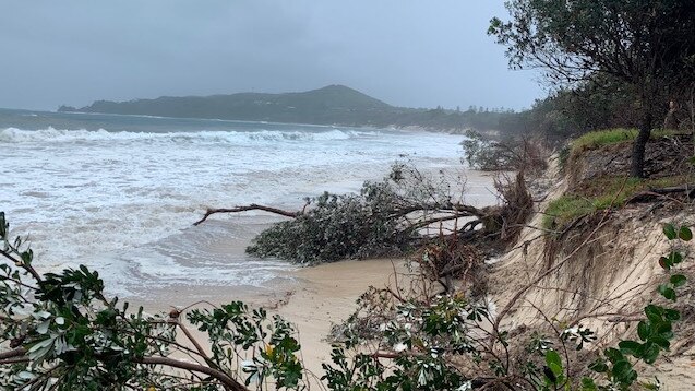
Byron Bay’s iconic beach has been washed away in a massive king tide, spurred on by wild weather, which has lashed parts of northern NSW and Queensland over the weekend.
Footage and images of Main Beach at Byron Bay on social media show the major tourist attraction being smashed by rough seas after sandbags were installed just over a month ago to help protect it.
Heavy rainfall overnight on Sunday, high winds and this morning’s high tide of 1.86m at 8.59am combined to wipe away the famous sands of Byron.
Byron Bay main beach is vanishing before our eyes ... today’s king high tide was 1.86m, tomorrow is 1.91m pic.twitter.com/V4vwygdY1f
— Scott Henry (@scoopnewsworthy) December 13, 2020
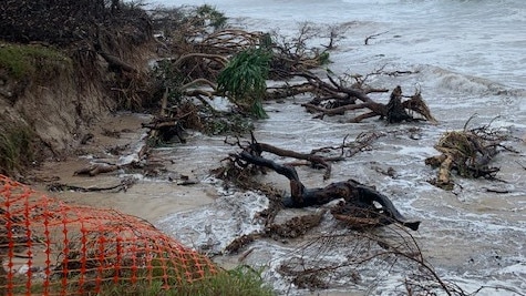
The heavy swell pummelled the sand dunes and caused trees to be swallowed into the sea. There are fears for Beach, a local restaurant, which overlooks Main Beach from above the dunes.
The area below the restaurant along a sea wall has been sandbagged.
With more rain forecast for Monday and the swell increasing, the signs are ominous for tomorrow’s king high tide of 1.91m, the biggest of the year, due at 9.47am.
Meteorologist Dean Narramore said Monday’s king tide had subsided, but waves continued to pound the shoreline.
WATCH: A man has tried to walk along the partially smashed walkway at Byron Bay as it collapsed.
— 9News Sydney (@9NewsSyd) December 13, 2020
He fell - but did not appear to be hurt.
Read more: https://t.co/Po5llD0jpe #9News pic.twitter.com/ueqgxHTynt
“The King tide is causing major coastal and beach erosion from Coffs Harbour all the way up through to the Sunshine Coast,” Mr Narramore said.
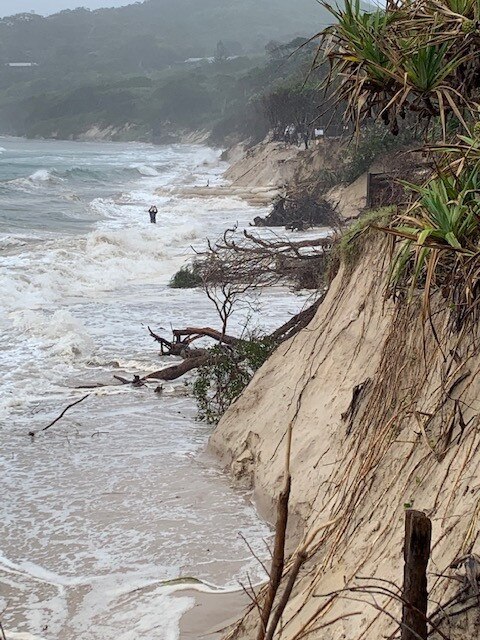
“There is already major erosion into Byron Bay and numerous other beaches are experiencing that right now,” he said.
“The king tide has passed, but we are still getting very strong winds pushing the water onshore and very large waves as well … up to eight metres offshore and waves of three to five metres in shore.”
Managing director of Beach Byron Bay – a restaurant and function venue located on eastern side of the tourist town’s Main Beach – said it was lucky the headlands and sandbagging had protected his business after a year of dangerous weather.
“While it’s very dramatic ... we are out of the worst of the effects,” Ben Kirkwood told The Australian.
“We were hit by an east coast low that hit more directly onto us back in June … and that took six metres of dune from in front of us and then every king tide after that we lost another two to three metres until we have lost 18 metres of dune and got within a metre of the front of this building,” he said.
After the massive swells hit the beach in June, Mr Kirkwood said Byron Bay mayor Simon Richardson lobbied the state government to urgently install a 300 metre sand wall along the beach.
“Thank goodness they did because this building would have been gone had that work not been finished by mid November,” he said.
“We already lost 18 metres and were in a vulnerable position and we would have lost the whole thing if it continued.”
Despite the destructive weather, Mr Kirkwood said patrons could still come to the venue which will host lunch and dinner as normal today.
“We are completely safe … we have been trading all morning,” he said.
“We will be doing lunch and dinner tonight and our guests will be getting dinner and a show first hand from Mother Nature.”
Wild weather warnings – including gale force winds, heavy rainfall and damaging surf – have been issued for parts of northern NSW and south east Queensland after they were drenched overnight.
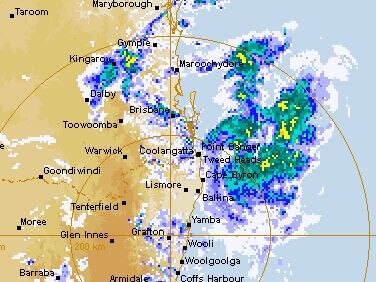
Look at that energy! The system that's causing heavy rain & localised flooding in northern NSW is seen here gathering pace as it tracks south from Qld. People in affected areas are urged to keep up to date with latest warnings, & put safety first: https://t.co/0ikQE2NKzl@NSWSES pic.twitter.com/3yTyhAAueQ
— Bureau of Meteorology, New South Wales (@BOM_NSW) December 13, 2020
Up to 700 millimetres of rain fell across the northern NSW coast after Tweed Heads recorded 252mm of rain, Byron Bay copped 76mm and Coolangatta clocked 166mm.
NSW SES Deputy Commissioner Daniel Austin said the authority had responded to almost 700 calls for help since Thursday, with about 50 overnight.
“Fortunately those calls were more to do with storm related issues than flood related issues,” Mr Austin told the Nine network’s Today show.
“We have had about 150 volunteers out on the street overnight working with communities to help them out,” he said.
Byron Bay is under sea level, when it smashes the park its a straight flow to Johnson St this has been known since before I was born though https://t.co/cnFPRMDy0U
— Aimee Maree (@aimee_maree) December 13, 2020
Authorities had acted earlier in the weekend and installed sandbags to protect some parts of the coastline, including Main Beach at Byron Bay, which has suffered massive erosion after a freak king tide.
“When we get these very deep lows off the coast we get very strong seas and we then see the erosion that comes with that,” he said.
A small number of properties in the coastal town of Sawtell near Coffs Harbour had to be evacuated last night due to the weather, Mr Austin said.
While severe weather can occur at any time of year, this is the peak period for #bushfires, #heatwaves, #floods and severe #thunderstorms in #NSW.
— Bureau of Meteorology, New South Wales (@BOM_NSW) October 12, 2020
Many thanks in advance to @NSWSES, @NSWRFS & other emergency workers in NSW who help keep us safe https://t.co/fANXVBHQ4I pic.twitter.com/JW0sS9X2kh
“Some of those waters came up in a pretty quick, short, sharp flash event (but) those people were back in their property shortly after,” Mr Austin told Sky News.
“We have also seen some significant downpours particularly towards the border area and some low lying areas with caravans … were evacuated for their safety early on,” he said.
“We expect that to continue later today and so we have been watching the second half of this event.”
Up to 9mm has already fallen on parts of northern NSW in the last hour and the Bureau of Meteorology has urged residents to brace for the worst.
Tropical rain, damaging winds and hazardous coastal conditions took hold in the north east of NSW and southern Queensland, meteorologist Jonathon How said on Sunday.
“Rainfall overnight on Saturday has been relentless and huge totals were recorded on both sides of the border,” Mr How said.
“Communities should prepare for minor to major flooding,” he said.
Rainfall rates overnight weren't as intense as Saturday night but steady showers have brought 188mm at Maleny, 186mm at Upper Springbrook since 9am Sunday. Heavier rainfall just offshore is expected to come ashore during this morning. Current warnings: https://t.co/jGPto9wLq4 pic.twitter.com/F1SAtQtunL
— Bureau of Meteorology, Queensland (@BOM_Qld) December 13, 2020
The wild weather was caused by a low pressure trough offshore of the southern Queensland coast.
Heavy rainfall is expected again early Monday as the trough will deepen and a low moves onshore at Southeast Queensland, The BOM said in a statement on their website.
“Heavy rain is expected to return to the Northern Rivers and parts of the Mid North Coast during Monday morning,” the statement read.
“Rainfall rates could be locally enhanced in the far north with thunderstorms, leading to the possibility of very heavy rainfall and dangerous flash flooding.”
Damaging winds are expected which will average between 60-70 km/h, with possible gusts of more than 90 km/h expected along the coastal fringe north from Yamba – about 100km south of Byron.
Massive waves – which will exceed more than 5 metres – are expected from top of northern NSW south to Port Macquarie during the day and could lead to “significant” beach erosion.
“Abnormally” high tides are also expected.
“The combination of Damaging Surf and Abnormally High Tides may enhance the risk of significant beach erosion north from about Ballina,” the BOM said.
A floodwatch has also been issued for south east Queensland after thunderstorms overnight.
A widespread deluge of rainfall totals of between 100-300 mm were recorded across the Logan and Albert – about 60km north of the Gold Coast – and south coast Rivers catchment areas in the 24 hours to 9am Sunday.
The SES in Queensland have responded to about 600 calls for help.
Add your comment to this story

Fortify where we must: PM urged to boost north defences
The Albanese government must transform and fortify northern Australia into an allied military stronghold, to respond to the ‘growing possibility’ of conflict with China, says a key US think tank.

Open attacks OK at table of consensus: Chalmers
Anthony Albanese’s economic reform roundtable is edging towards bitter acrimony between unions and business amid private sector concerns the government is running a ‘protection racket’ for unions.
To join the conversation, please log in. Don't have an account? Register
Join the conversation, you are commenting as Logout