North Queensland flood warnings upgraded
Townsville and Ingham could cop another 300mm drenching on Tuesday as a new storm front threatens to hinder recovery efforts in the sodden region.
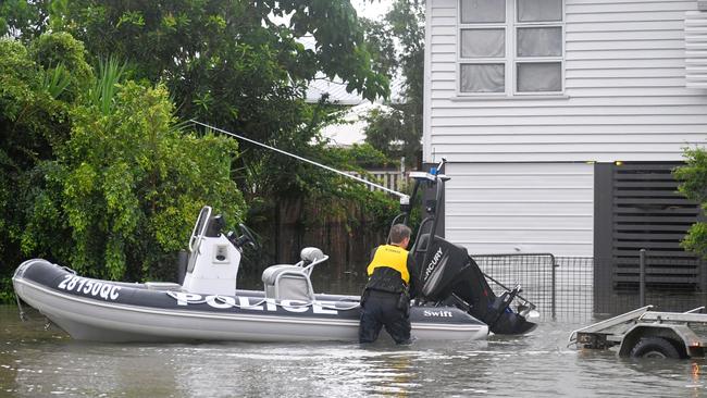
Flood-hit Townsville and Ingham could face another 300mm drenching on Tuesday as a new storm front threatens to hinder recovery efforts in the sodden region.
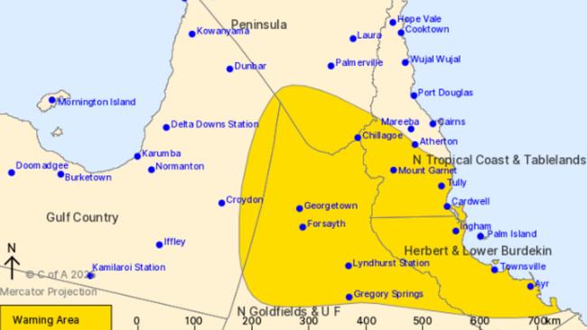
The Bureau of Meteorology has warned of heavy rain and potentially “life-threatening flash flooding” on Tuesday, with the agency upgrading its warnings across the state’s north and far north coasts.
The lingering monsoonal trough is expected to belt Queensland’s already saturated north late Monday and into Tuesday, hitting areas between Croydon in the Gulf Country, through to Atherton and the stretch of east coast from Tully to Ayr.
In the 20 hours to 5am Monday, Rollingstone and Paradise Lagoon, both near Townsville received 143mm and 88mm of rain respectively, while 104mm hit at Kowanyama.
The drenching comes after nearly two weeks of record-breaking rain across the region, with Townsville hitting its highest February rainfall – 1033mm – in just the first week of this month. Some areas have recorded one in 2000-year rainfall, according to the Bureau.
Bureau of Meteorology general manager Matthew Collopy said Queensland’s north remains vulnerable to more flash flooding in the coming days.
“Rainfall over the last 10 days has resulted in extended major flooding over northern Queensland, and continues to present a heightened risk of both flash and riverine flooding,” Mr Collopy said.
Major flood warnings were issued for the Herbert River, the Cape and Upper Burdekin Rivers, as well as the Haughton River and the Flinders Rivers.
Many residents remain stranded, with more than 300 roads across Queensland still closed. Singaporean air force helicopters have flown in essential groceries to several towns still cut off around Townsville, including Ingham.

Around 1500 homes in Townsville and the Hinchinbrook Shire remained without power on Monday, according to a spokeswoman from energy provider Ergon.
“Since the flooding began, we have gotten power back to 32,000 homes,” she said.
“It’s really Ingham that has borne the brunt of those outages. We believe we’re at that final hurdle now and hoping that every home, where it is safe to do so, will be back on the network by 10pm Monday night.”
With another drenching on the way Ergon Energy would “look into” airlifting power generators to areas where flood damage makes it unsafe to get on the network.
The tropical low creating this weather is predicted to move off the coast of Townsville by Wednesday, offering some relief for residents in the region.
“Even after the rain eases there is a lot of water that is already on the ground and coming through those rivers, so the flooding risk will continue even after the rain,” Mr Collopy said.

Add your comment to this story

Cashed-up grey army bringing salvation to regional towns
A grey army is saving Australia’s bigger regional towns, retiring from farms and smaller towns to centres such as Horsham. They bring cash, skills and vibrancy.

Candidate ‘lying’ about Lib plans for Whyalla steelworks
A Climate 200-backed candidate in SA, Anita Kuss, has been accused of falsely implying to voters a Dutton government could withdraw support for the $2.4bn Whyalla steelworks rescue.
To join the conversation, please log in. Don't have an account? Register
Join the conversation, you are commenting as Logout