Worst of weather passed but warnings remain in Australia’s east
The worst of a low pressure system that brought wild winter weather to half of the country has passed, but weather warnings still remain across the east.

Although the worst of the wild weather that lashed the nation has passed, a number of weather warnings remain in place in Australia’s east.
Towns in NSW’s inland rivers region and Gippsland in Victoria have been told the brace for potential major flooding due to the heavy rainfall.
Forbes, Cowra, Cotton‘s Weir and Nanami in rural NSW and Glenaladale in Victoria’s east were in the firing line as dams and rivers threaten to overflow.
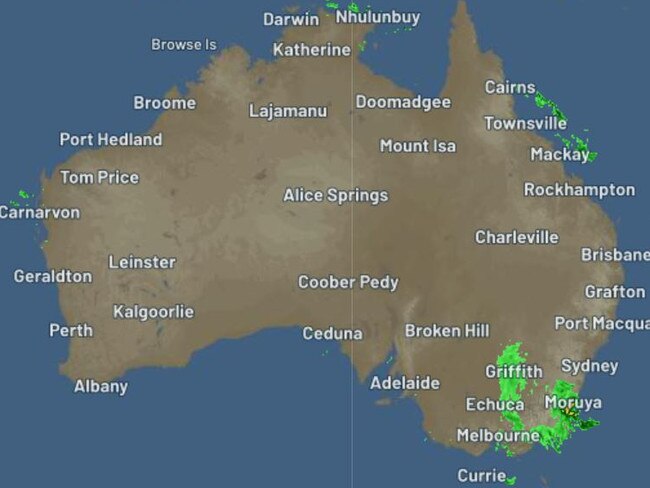
In recent days a cold front moved east across Australia, bringing wild storms and flooding to parts of South Australia, Queensland, NSW, Victoria and Tasmania over the past few days.
Weatherzone meteorologist Felix Levesque said the wild weather was associated with a trough that continued to move east overnight and now is sitting off of the Queensland coast.
All that remains is a low pressure system sitting over the southeast corner of the country that will still bring some rainfall, mostly to eastern and central Victoria and southeast NSW as well as some parts of Tasmania, western Victoria and southeast South Australia.
“Now that it's pushed offshore we’re got some dry, cool, crisp winds that pushed over the regions,” Mr Levesque said.
“We have mostly sunny skies across Queensland … as well as South Australia and northern NSW that had very significant rain over the last week.
“That low pressure system over the south east will be pushed offshore over the Tasman and that will clear rainfall for those eastern Victorian and south east NSW part.”
Mr Levesque said another cold front would move into southeast South Australia, Victoria, Tasmania and southern NSW on Sunday and would mostly bring gusty showers.
But he said a high pressure system will build on Tuesday which will bring “a release” to already lashed areas.
Despite the weather conditions slightly easing, there are still severe weather and flood warnings across the nation.
According to the Bureau of Meteorology, NSW and Victoria will cop the most amount of rain on Saturday with some parts predicted to have between 25mm and 50mm.
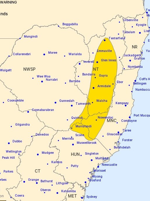
In NSW, a severe weather warning for damaging winds is in place for people in parts of Mid North Coast, Hunter and Northern Tablelands Forecast Districts.
Residents in and around Armidale, Tenterfield, Glen Innes, Guyra, Walcha and Uralla are warned of possible peak gusts in excess of 90 km/h on Saturday.
Yesterday, winds of 95 km/h were recorded in Murrurundi and Glen Innes on Friday afternoon while Armidale Airport recorded 87 km/h at 2.30pm.
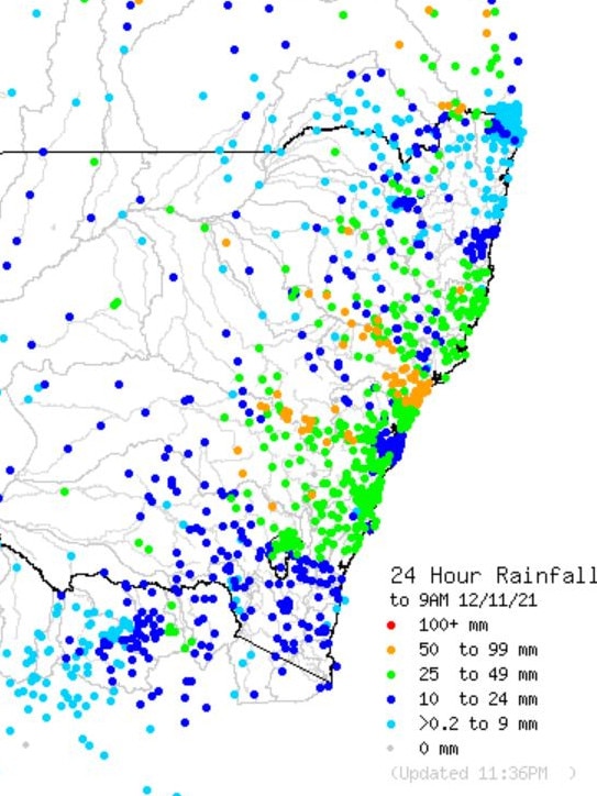
Over the past 24 hours, a large number of locations near the NSW coast — spanning from Majors Creek and Lake Tabourie up towards Kempsey — recorded between 25 to 49mm of rain.
The most amount of rain was recorded surrounding the Maitland area where Broadmeadow recorded 86mm.
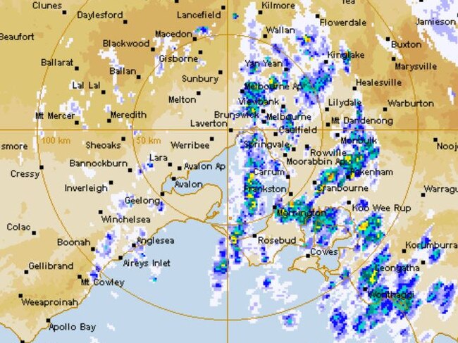
In Victoria, residents in East Gippsland and parts of West and South Gippsland Forecast Districts could be hit with heavy rainfall as a severe weather warning remains.
It can bring flash flooding as 24 hour rainfall totals of 40mm to 70mm are predicted over Gippsland, while up to 80mm to 120mm is forecast across the Gippsland high country and the Strzelecki Ranges.
Mt Moornapa recorded the highest rainfall since 9am Friday, reaching 109mm.
It was followed by Balook that had 85mm fall while 76mm was recorded at Briagolong.
A 90 per cent chance of rain is forecast for Melbourne in the morning that could ease to a shower or two during the afternoon.
Meanwhile in Queensland, South East Gulf of Carpentaria, Sunshine Coast Waters, Moreton Bay and Gold Coast Waters have a strong wind warnings for Saturday and it are expected to remain for South East Gulf of Carpentaria on Sunday.

Aussies staple you’ll be lucky to find
Floodwaters in North Queensland have cut off supply routes for an Aussie staple that will be in short supply at your local supermarket.
Gabba education vital for Konstas
The NSW team is more than happy to have Sam Konstas back from Australia’s tour of Sri Lanka to play against Queensland at the Gabba.