Weather: Adelaide’s CBD has wettest day in five years, Sydney to be hit Saturday
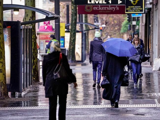
A cold front moving easterly across the country is bringing torrential rain, with one capital recording its wettest day in five years.
A cold front moving easterly from Central Australia has brought torrential rain to one city while another is about to be hit.
The weather system brought rainfall that lashed the South Australian capital overnight, which recorded its wettest day in five years.
It will continue to move over the east coast and meet with a separate low-pressure system in the Tasman that will then be pushed north along the NSW coast and bring damaging winds and damaging surf.
Adelaide’s West Terrace weather gauge recorded 46mm of rain over the past 24 hours before 9am on Friday, making it the wettest June day in the CBD since 2005 and the wettest day since December 2016.
The Bureau of Meteorology issued a road weather warning for Adelaide as visibility was reduced and the heavy fall made road conditions dangerous in the morning.
SA Police also advised commuters to take extra care and driver slower, to keep a safe distance behind the vehicle in front and to turn headlights on.
Showers with up to 0.8mm of rain are forecast to continue in the CBD on Friday, reaching a top of 16C.
Adelaide and the Mount Lofty Ranges were hit with the most rain, while areas in other districts only had a sprinkle or no rain at all.
BoM senior meteorologist Dean Narramore said having such a large amount of rainfall within the short time frame was unusual.
He said the system had already weakened as it moved further east and did not anticipated further record-breaking rainfall figures.
💧 45 mm for #Adelaide up to 7 am with more showers to come🌧ï¸The wettest June day in Adelaide since 2005 and wettest day since December 2016. https://t.co/WpV7kFjFjVpic.twitter.com/efyhBB2rIS
— Bureau of Meteorology, South Australia (@BOM_SA) June 17, 2021
Sydneysiders are also expected to be hit by downpours over the weekend.
According to the weather bureau, up to 15mm is predicted to fall over Sydney on Saturday, with a 95 per cent chance of showers along the coastal fringe and a 70 per cent chance elsewhere.
Gusty south-westerly winds are also forecast in the late morning and afternoon, reaching up to 45 km/h.
Those showers are predicted to continue over the week, fluctuating between medium to high chances through to Thursday.
However, the average daily rainfall is said to gradually decrease to up to 2mm on Tuesday and Wednesday before increasing again to a maximum of 6mm on Thursday.
Weatherzone meteorologist Joel Pippard said NSW’s weather would be impacted by the cold front that moved from South Australia in conjunction with the low-pressure system that developed east of Bass Strait on Wednesday.
He said the Tasman low brought some moderate rainfall to eastern Tasmania and Victoria on Friday morning and would be pushed further north, bringing damaging winds and damaging surf to a large portion of the state’s coast.
“It will impact mainly Sydney’s coast as well as the city, but Sydney’s west won’t be impacted as much as the east,” Mr Pippard said.
“Because that low is moving up, there will be a strong southerly change move through later tonight and would start impacting from 11pm.”
BoM currently has a severe weather warning for damaging winds and damaging surf in place for people in parts of the Mid North Coast, Hunter, Metropolitan, Illawarra and the South Coast Forecasts Districts.
Winds of up 70 km/h with peak gusts in excess of 90 km/h are possible from early Saturday morning through to the evening.
According to BoM, those gusts will likely be associated with showers and thunderstorms pushing over the coastal fringe.
It has also warned very heavy surf could lead to localised damage and coastal erosion for beaches south of Seal Rocks and a hazardous surf warning has also been issued for the coastline south of Coffs Harbour.
âš ï¸ #Severe Weather Warning âš ï¸#DAMAGING#WINDS are possible from early Saturday morning along the south coast, shifting up the coastline into Saturday afternoon and evening. DAMAGING #SURF is possible for S-SE'ly facing beaches south of Seal Rocks. 🌬ï¸ðŸŒŠhttps://t.co/QLXu59pSaQpic.twitter.com/rUS7qNqDmG
— Bureau of Meteorology, New South Wales (@BOM_NSW) June 17, 2021
The same weather system in the Bass Strait will begin bringing widespread rain to eastern parts of Victoria, particularly in East Gippsland.
A warning for minor flooding in the Bemm, Cann and Genoa River catchments is in place from Friday evening.
According to the weather bureau, rainfall totals of 25-40mm are forecast for East Gippsland on Friday as well as isolated areas reaching up to 60mm in the ranges.
It is predicted a further 10-20mm will fall across the region on Saturday.
There are also ongoing flood warning for Yarra River, Latrobe River and the Thomson River which are slowly easing from flooding last week.
A severe weather warning is also in place for damaging winds in the North East Forecast District, with winds reaching 60-70 km/h and peak gusts of 100 km/h forecast to develop across elevated parts later tonight.
It is predicted to ease below the warning threshold by late Saturday morning.
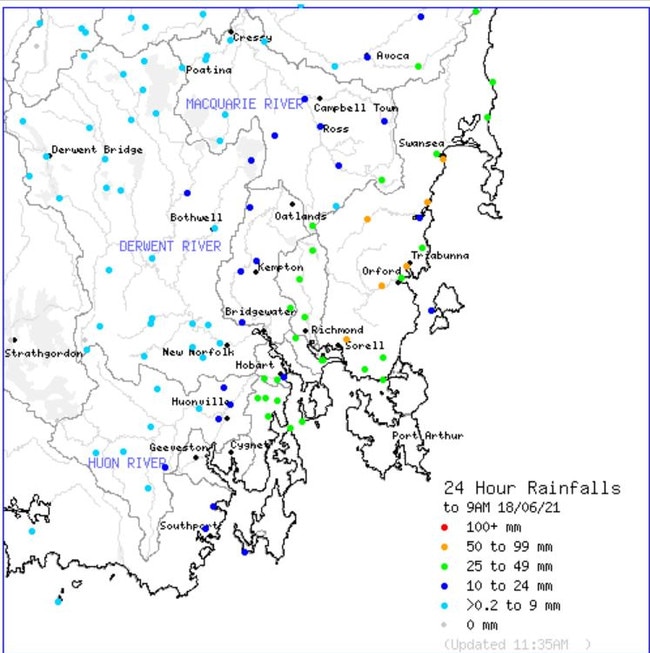
Over the past 24 hours, Tasmania’s east coast was also struck with heavy rainfall with some areas recording more than 60mm of rain.
The highest rainfall total for the day was 68mm in Little Swanport, located near the Great Oyster Bay shores between Swansea and Triabunna.
It was followed by Swansea and Wattle Hill which both had 54mm.
Hobart recorded only 22mm and 26mm was recorded at its airport.
A number of flood watches or warning remain in place for the Macquarie River, South Esk River, Coal River and the Jordan River.

Aussie champ to test anti-gay laws
After outrage from the family of an Aussie star when the World Surf League confirmed an event in an Abu Dhabi wave pool she’ll hit the event this week as world No.1.

‘I’ll kill them’: Outrage over vile anti-Semitic rant
NSW Health has responded to a video of two people wearing NSW Health uniforms vowing to “kill” Israeli patients seeking care.