Wild winds rip window from apartment in Sydney after a morning of havoc in Melbourne
Wild weather has lashed several states, bringing golf ball-sized hail, falling trees and winds that tore a large window from an apartment block.

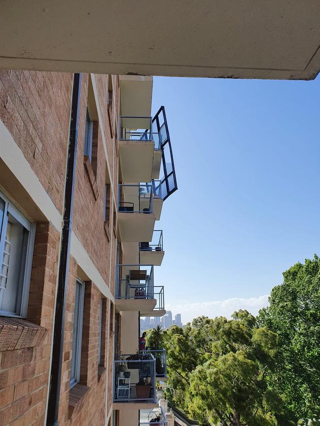
Strong winds are believed to have torn a large window pane out of a Sydney apartment on Friday afternoon, following a morning of weather-induced havoc in Melbourne.
NSW Fire and Rescue was called about 4.30pm to the unit block on Sutherland St, Paddington where a window was dangling from one of the apartments.
Firefighters went up through the elevator and pulled it back into the apartment using ropes.
Winds reached up to 87km/h in Sydney’s south about 3.30pm and 78km/h on Sydney Harbour just after 6pm.
Sydneysiders sweltered through their warmest day since January, with the mercury climbing to 34.3 degrees at the airport – which was the hottest part of the city – by about 1pm.
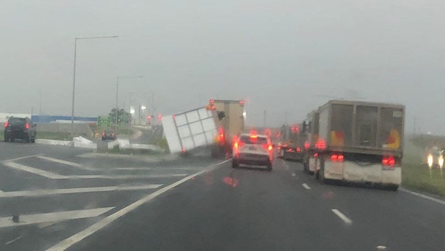
Earlier, Victorians battened down the hatches, as strong winds of up to 110km/h – well over what is considered gale-force – swept across the state, ripping roofs off houses, tearing trees from the ground and even flipping a truck over on a major Melbourne road.
Footage captured the moment a roof was torn off a Port Melbourne apartment block and large chunks of styrofoam careened past someone’s window during the chaos.
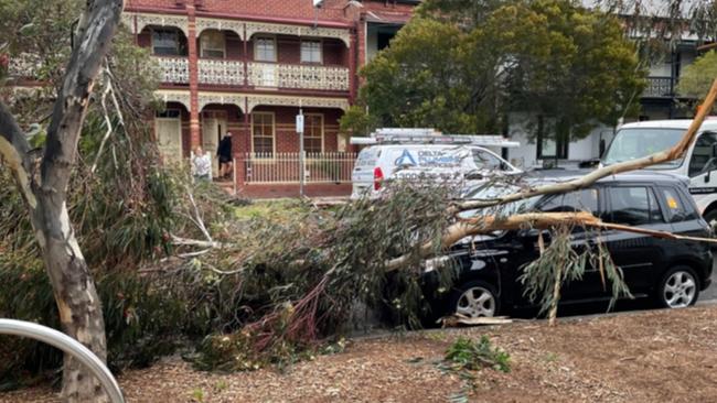
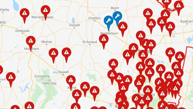
Thousands of homes across Victoria and South Australia remain without power on Friday after severe wind, hail and heavy rain ripped through neighbourhoods, leaving a trail of destruction.
Melbourne residents woke to severe wind and rain, with motorists warned traffic lights were out across the city, while fallen trees were blocking roads and also the Glen Waverley train line.
Photos showed trees that had been uprooted during the extreme morning blast.
High winds began to ease late in the morning in Melbourne, but thousands of residents were still struggling with power outages.
There were at least 50,000 AusNet customers in Victoria’s east without power.
“And I thought there were only four horsemen of the apocalypse,” wrote Melbourne-based comedian and actor Magda Szubanski.
“This is getting scary. Take care people.”
In Melbourne, motorists have been told to drive with extreme caution.
V/Line, which operates regional passenger train and coach services, warned that, “due to extreme weather conditions across the state, train services will be held in place until tracks can be cleared from debris.
“Coaches have been deployed across the network to assist with travel. Additional information will be made available once confirmed.”
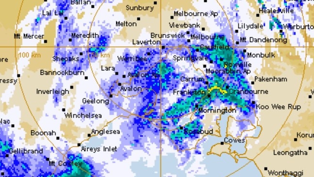
Doppler radar shows the southwesterly wind change moving across Port Phillip bay, with wind gusts as high as 135km/h at South Channel Island. Damaging winds will continue to buffet #Melbourne for a couple more hours, but should be easing by around 10am. https://t.co/I59KuWUC9kpic.twitter.com/I5nky6Ay7K
— Bureau of Meteorology, Victoria (@BOM_Vic) October 28, 2021
A number of Covid-19 vaccination sites have also been temporarily closed amid the wild weather.
The Bureau reported more than 500,000 lightning strikes have hit South Australia, Victoria and southern NSW over the past 24 hours, as a deep low pressure system moves towards Bass Strait.
Hobart copped 40mm overnight and several areas of Tasmania are on floodwatch.
Two teenagers had to be rescued near the central Tasmanian community of Campbell Town on Thursday night, with police and rescue services using a boat to free the girls trapped in flood waters from the Elizabeth River.
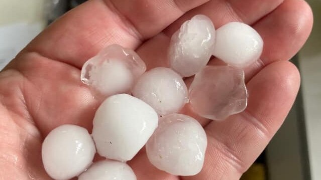
Elsewhere, a huge damage bill is expected for Adelaide and surrounding regions after golf ball-sized hail pelted the suburbs on Thursday, and severe wind triggered thousands of calls for assistance to the State Emergency Service.
The weather was so intense that the Bureau of Meteorology Adelaide office had to be evacuated.
SA WILD STORMS:
— Ollie Haig (@ollie_haig) October 28, 2021
- SES has received 1200 call outs in past 24 hours.
- 12,000 homes across state without power this morning.
- Damage widespread including metro Adelaide, Hills, Barossa Valley. @TheTodayShow@9NewsAdelpic.twitter.com/PXnDnf44fC
Many South Australian homes remained without power on Friday morning, with authorities working to clear trees that fell overnight.
“Batten down the hatches. I have thousands of dollars’ damage to my house and a couple of cars with damage, including my poor son’s, which is probably a write off,” wrote Penny Artis on Facebook.
That intense system has moved east, and on Friday morning was bearing down on Victoria, bringing torrential rain, damaging wind, and cutting power to thousands of homes.
The state’s west and northwest appeared to be particularly affected by outages.
“It was spectacular last night, watching the light show, which went on for hours and hours,” wrote Caroline Jane Knight.
“But it was so loud, all night, I’ve hardly slept at all. No power this morning, the wind storm is still going.
“Just went out to find a coffee and half the roads are blocked by fallen branches, we’ve gone miles to get to a coffee shop with power.”
Gusts of 143km/h were reported at Mount William in the Grampians National Park – nearly double what is considered “gale force” – while a severe weather warning was active for the western and central Victorian coasts, Greater Melbourne, Gippsland and the Mornington Peninsula.
The Bureau of Meteorology said the danger was likely to shift towards northern NSW and Queensland this afternoon.
Severe thunderstorms for parts of #NSW today. Red areas show where severe storms are likely, but not all towns in this area will see storms, amber areas may see severe storms but severe storms are not likely. Damaging winds most likely but hail and heavy rain possible. pic.twitter.com/kTZgJvnhVk
— Bureau of Meteorology, New South Wales (@BOM_NSW) October 28, 2021
“It’s about Victoria and Tassie this morning, but things are already shifting,” said senior meteorologist Jonathan How.
Mr How said the steamy temperatures experienced across northeast NSW and southern Queensland of up to 36 degrees would be hosed down by a potential supercell thunderstorm on Friday afternoon.
“There’s also the possibility of tornadoes; we can’t rule that out,” Mr How said.
The system will linger over Brisbane and the Gold Coast into Saturday before easing on Sunday.
Gabba education vital for Konstas
The NSW team is more than happy to have Sam Konstas back from Australia’s tour of Sri Lanka to play against Queensland at the Gabba.
Man made death threats to MPs, cops allege
A 33-year-old man allegedly made death threats and attempted to contact two members of parliament, in what police believe was an anti-Semitic abuse.