State braces for second day of severe storms and flash flooding
More than 20 people have been rescued after becoming trapped in floodwaters while thousands are without power as storms threaten to smash NSW for a second day in a row.
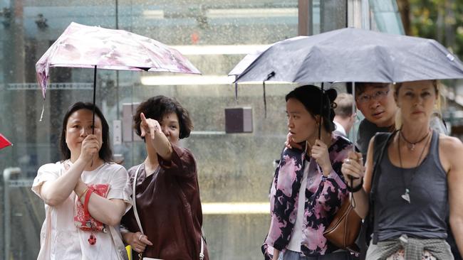
Sydney is set to be pummelled with further rain and thunderstorms just a day after the it was hamemred by wild weather.
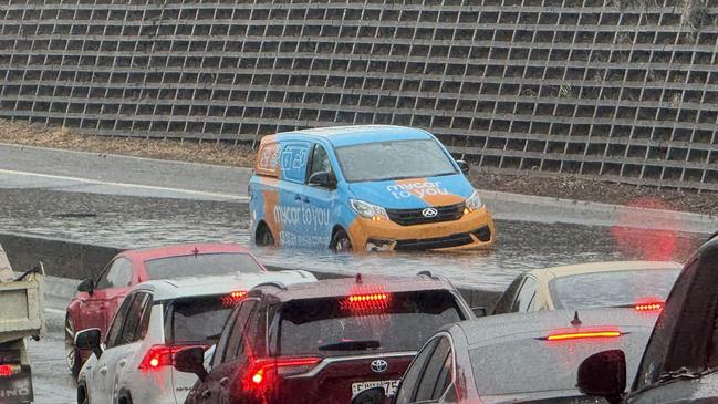
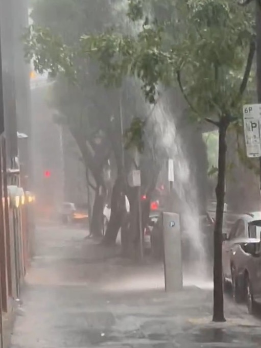
On Monday, the city was lambasted by a lunchtime storm, with up to 80mm of rain recorded in Horsley Park in under an hour, and 52mm of rain recorded in the CBD in just 90 minutes.
The NSW State Emergency Service (SES) received more than 770 calls statewide and over 750 volunteers assisting in rescuing those who became stuck in rapidly rising floodwaters.
Harden in the state’s South West Slopes was the hardest hit during the intense storm, with more than 150 calls made to the SES after the wild weather brought a barrage of rain, destructive winds and giant hailstones.
The storm also smashed parts of the city, including Blacktown, Penrith, Fairfield, Parramatta, Liverpool and the City of Sydney.
The SES came to the assistance of 21 people who became stuck inside their vehicles as they drove through the floodwaters in the Sydney metro area.
No injuries have been reported amid the wild storms.

While the storm that brought the deluge has moved offshore, the chaos isn’t over just yet, with other parts of NSW anticipating further storms, albeit not as severe.
Sky News Weather meteorologist Ben Sharpe warned of “potentially” similar conditions in NSW on Tuesday, with “new band of storms” forming from Dubbo to Newcastle.
“That’s kind of a line that I think is the dividing line of today’s storms,” he said, adding pockets of the northern regions oculd see “damaging winds and large hail”.
An SES spokesman told NewsWire the widespread thunderstorms are likely to hit the Hunter and MidNorth regions of the state.
While the SES are not expecting “what we saw yesterday”, residents have been warned of “thunderstorm activity in the early afternoon”.
The bureau cancelled a severe weather warning for the South Coast shortly before 5am Tuesday.
“The immediate threat of severe weather has passed, but the situation will continue to be monitored and further warnings will be issued if necessary,” the statement read.
As the lashings of rain and gusty winds hit the city, thousands of residents were left in the dark as power and internet outages swept over the state.
The internet outage, which was caused by a storm-related power outage in Sydney, affected TPG, iiNet, Vodafone and Kogan customers. TPG apologised for the outage on Monday afternoon.
Between 10,000 and 12,000 residents were left without power amid the storms.
While the majority have had power restored, the widespread power outages continued into Tuesday morning with over 1,800 homes and businesses remaining without power, 1,200 of which are in Cardiff, Cardiff Heights, Garden Suburb, New Lambton Heights, Macquarie Hills, Edgeworth, Kotara and Adamstown.
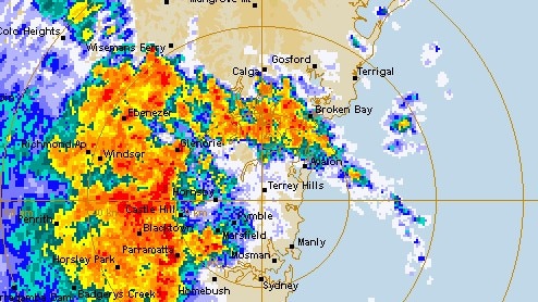
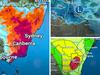
About 11.20am Monday, the BOM issued a severe thunderstorm warning for Metropolitan, Central Tablelands and parts of Hunter, Illawarra, Central West Slopes and Plains, Lower Western and Upper Western Forecast Districts about 11.20am.
“Severe thunderstorms are likely to produce heavy rainfall that may lead to flash flooding, large hailstones and damaging winds in the warning area over the next several hours.”
Sydney, Gosford, Orange, Katoomba, Dubbo and Parkes were all in the firing line, with the SES telling residents to avoid leaving their homes if they could.
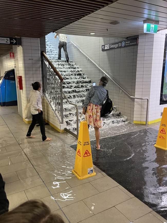
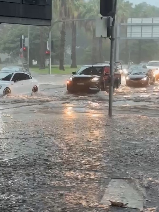
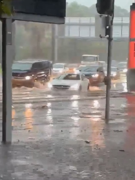
Cars were wading through flooded streets on Monday and Sydney’s Town Hall Station was flooded as heavy rainfall smashed the city, with lashings of water running down the steps and filling the train station’s platform.
In Murrumburrah, 47mm of rainfall was recorded in half an hour, 45mm of rainfall was recorded in 30 minutes at Fairfield City Farm, while 77.6mm of rainfall was recorded in Horsley Park in an hour to 11.50am.
BOM senior meteorologist Miriam Bradbury warned the destructive wind gusts could reach speeds in excess of 125km/h and “giant-sized hail” and locally intense rainfall that could “quickly lead to life-threatening flash flooding”.
Massive hailstones reaching between 2cm and 6cm in diameter battered down in Boorowa, Harden and Temora.
“Be aware of that risk of extra debris on the roads or about your own property through the course of today, thanks to those thunderstorms,” she said.
The rain won’t be going anywhere anytime soon, the bureau warned, as the low pressure trough draws in moisture from the north and off the ocean and “(feeds) it into any showers, storms and rain areas that develop”.
“It’s fairly stagnant,” Ms Bradbury said.
“It’s not moving anywhere very quickly, which is why we’re seeing this risk of storms and rainfall continuing day after day.”
Thunderstorm conditions are expected to stick around until at least Wednesday before moving in an northerly direction towards northern NSW and southern Queensland.
The thunderstorm warning has stretched across much of the southeast of NSW, the ACT and Victoria, with a thunderstorm warning in place for residents in Gippsland and NSW’s south coast.
Rainfall is expected to be widespread in the areas over the next couple of days, the bureau stated, with falls reaching between 30mm to 80mm in some areas, and isolated falls reaching up to 120mm in pockets of the state.
Wild winds and storms battered the east coast and parts of the city, with flash flooding in Painesville and Lakes Entrance.

Add your comment to this story

‘Evil’: Son’s ‘pleasure’ in killing parents
An Aussie who nursed “violent fantasies” years before brutally murdering his parents is fighting his sentence more than a decade after he was jailed.

High ranking cop charged with stalking
One of Western Australia’s highest ranking police officers has been stood down and will appear in court next month on a stalking charge.
To join the conversation, please log in. Don't have an account? Register
Join the conversation, you are commenting as Logout