Strong winds, storms sweep across Tasmania
One state’s residents are being urged to prepare for a blast of wild weather, with dangerous wind gusts, thunderstorms, and rain forecast for days.
Tasmania is facing several days of severe winds, with damaging gusts forecast to sweep across the state from Monday afternoon through to Wednesday, prompting widespread weather warnings.
Angus Hines from the Bureau of Meteorology said the strongest winds were expected to hit Monday night into early Tuesday, with the worst of the weather likely to affect much of the state, including Hobart.
“Monday to Wednesday is the key time period where we have got a warning in place which covers much of the state,” Mr Hines said.
“Hobart, the capital, is included in the warning.”
He said damaging wind gusts could reach 100km/h or more for those living at elevation.
“If we do see winds of this speed, they could take down trees and branches. They can fall over roads, potentially closing those roads and they may damage cars and property,” Mr Hines said.
He warned that the dangerous conditions could also cause power outages, particularly in elevated or exposed areas.
“The entire state is covered by those very strong winds,” he said.
Thunderstorms are also possible on Monday afternoon and into the night, with rain expected in parts of the state.
“Most of the falls will be in the mountains and on the west coast,” Mr Hines said.
Some showers are also expected in the north and west.
The winds are expected to ease during Tuesday before picking up again late Tuesday night into Wednesday morning.
“We will see a gradual easing on Wednesday into Thursday,” Mr Hines added.
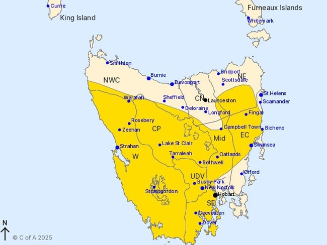
A severe weather warning for damaging winds has been issued for people in the Western, Upper Derwent Valley, South East, East Coast, Central Plateau, Midlands, and parts of the North East, North West Coast, and Central North forecast districts.
According to the bureau, a cold front embedded in a vigorous northwesterly airstream is crossing the state, bringing strong to damaging winds of 55 to 65km/h, with peak gusts up to 100km/h in most areas and up to 120km/h in elevated or exposed locations.
The damaging winds are expected to ease below warning thresholds during Tuesday morning but will likely remain gusty throughout the day.
Locations that may be affected include Swansea, Strahan, New Norfolk, Hobart, Geeveston, and Dover.
While strong winds are also forecast for parts of Victoria, Mr Hines said they were not expected to reach warning thresholds there.

Bombshell ‘genocide’ finding in Aussie report
A landmark report by Australia’s first formal truth-telling commission has released shocking findings about the treatment of Indigenous Australians.

If you live here, work from home tomorrow
Millions of Aussies have been told to stay home and avoid travelling if necessary after a freak “cyclone bomb” sparked commuter chaos and led to services being cancelled.