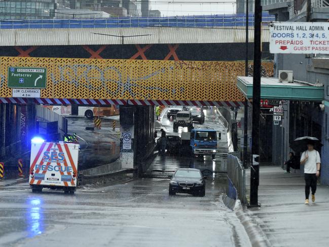
Flash flooding causes traffic chaos as rain continues to batter parts of the east coast
Lives could be at risk from flash flooding and severe storms across much of the east coast, the weather bureau has warned.

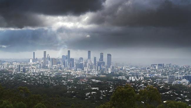
Summer storms and flash flooding could put lives at risk in large parts of Australia, the Bureau of Meteorology has warned.
Meteorologist Miriam Bradbury said in a video posted to social media that there was a “significant rain band” that had already moved through southeastern South Australia and western Victoria since Tuesday, bringing moderate rainfall.
“The rain band is now sitting across central Victoria and Tasmania, with more scattered showers and storms across much of NSW,” she said.
“It’s all associated with a low pressure system … rotating to the west of Tasmania.”
Ms Bradbury said the system was moving quickly, so conditions were clearing “relatively rapidly” after it crossed.
The trough driving the rain band was to the east of Melbourne on Wednesday afternoon and would continue to move east, affecting eastern Victoria, eastern NSW and eastern Tasmania.
“Through this afternoon, the risk of heavier falls is still persisting through parts of Victoria and southern NSW,” she said.
“It is still requiring a severe weather warning for heavy rainfall that may lead to flash flooding.”

That weather warning is for northeastern Victoria and southeastern parts of NSW.
“In that warning area we’re more likely to see widespread moderate to heavy falls, which are more likely to bring about that flash flooding,” she said.
“It is a hazardous situation which may quickly cut off roads and access routes and cause minor flash flooding issues.”
Thunderstorms are currently isolated and scattered but Ms Bradbury warned they had the potential to become severe, bringing heavy rainfall, flash flooding, damaging winds and the risk of large hail.
Additional thunderstorm warnings could be issued on top of the severe weather warnings in much of Victoria, NSW and Tasmania, Ms Bradbury warned.
The trough will continue to move east on Thursday but wet weather is expected to continue in many parts until the end of the week.
Severe Weather Update: Find out what to expect across the country over the coming days. Video current 11.45am AEDT, Wednesday 17 January 2024. Latest: https://t.co/4W35o8iFmh or the BOM Weather app. pic.twitter.com/ONhRnM5hZq
— Bureau of Meteorology, Australia (@BOM_au) January 17, 2024
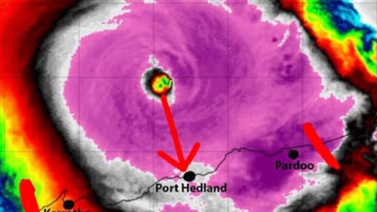
Meanwhile, Tropical Cyclone Anggrek is currently slow-moving to the northwest of the Cocos (Keeling) Islands.
It is expected to slowly intensify over the next 24 to 36 hours, and is forecast to pass to the west of the Cocos (Keeling) Islands during Thursday and Friday.
While Perth has experienced a heatwave in recent days, the mercury is finally dipping to an expected maximum of 31C.

Earlier on Wednesday, a meteorologist warned storm ravaged Queenslanders could face round after round of potentially devastating tropical cyclones, with still-recovering communities put under a renewed threat.
Sky News meteorologist Rob Sharpe said research had showed a positive Southern Annular Mode (or SAM) combined with an El Nino weather event could lead to an increase in severe tropical cyclones.
The SAM is a hard to predict phenomenon where westerly winds circling Antarctica become stronger, which increases the dominance of high pressure systems in southern Australia.
This in turn guides moist onshore winds onto Australia’s eastern seaboard, increasing the likelihood of heavy rain and intense tropical cyclones.
“A study in the Journal of Climatology found that when a positive SAM event combines with El Nino cyclone numbers off the Australian east coast are only slightly below normal,” he said.
“Interestingly the research found there have been a greater number of severe tropical cyclones compared to normal in this climate scenario.”
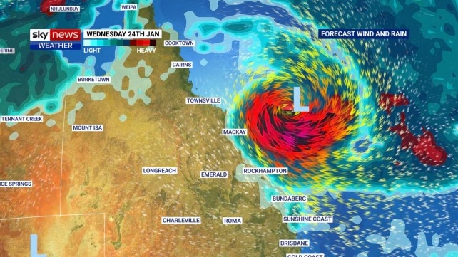
Mr Sharpe’s warning comes as the Bureau of Meteorology flagged a developing tropical low in the Coral Sea is likely to strengthen over the weekend, with a high 55 per cent chance it could develop into a cyclone.
As it stands, meteorologists are unable to forecast the movement of the potential cyclone, however the Bureau flagged “there is a chance” the system could develop into a severe tropical cyclone early next week.
While “no direct impacts” are expected for the Queensland coast over the next seven days, things could change from early next week if the tropical cyclone begins moving west towards Australia’s coastline.
A tropical low in the Coral Sea is now rated as a high (55%) chance of being a tropical cyclone from Sunday. The system is expected to remain offshore over the next 7 days, however uncertainty in its movement increases from early next week.
— Bureau of Meteorology, Queensland (@BOM_Qld) January 16, 2024
TC Outlook: https://t.co/hw63OUtpAPpic.twitter.com/nij1q6dvPh
Just last month, parts of the Far North Queensland were devastated by Category 2 Ex-Tropical Cyclone, which made landfall on December 13, leading to a series of severe storms, and raging winds.
As Queenslanders eye a renewed cyclone threat, Tropical Cyclone Anggrek, currently about 500km off the Cocos Islands could also bring gale force winds to the tiny remote territory.
However the weather event is expected to begin weakening from Friday, with a high unlikelihood it will impact mainland Australia.
Warning after 60 rescued in major flooding
Emergency services are continuing efforts to rescue stranded residents and assist in recovery operations.

Reds star staying patient in comeback bid
With a ‘weird’ 2024 behind him, Queensland Reds co-captain Liam Wright is eager to return from a shoulder injury that has sidelined him since July.