Wild weather smashes five states throwing commuters into chaos
A spate of wild weather has brought on flash flooding across five states, with footage capturing the moment a ritzy restaurant in Sydney’s east was flooded.
Train services were thrown to chaos and cars left abandoned as five states were smashed by flash flooding amid wild rain and thunderstorm.
NSW, Queensland, Victoria, Tasmania, South Australia, and even the Australian Capital Territory were smashed by rain on Sunday, with some areas experiencing flash flooding.
Queensland was hit the hardest by the wild weather, with the Gold Coast hinterland inundated with rainfalls of more than 200mm in just 24 hours according to Weatherzone.
The rainfall caused some river levels to rise up to 10m in just 12 hours, while Brisbane experienced more than 40mm of rain in an hour on Sunday.
Drivers were reportedly forced to leave their cars amid the wild weather in Queensland as the five states experienced some of the largest rainfall in years.
Sydney clocked more than 25mm of rain in an hour while Canberra and Hobart each recorded about 10mm within an hour.
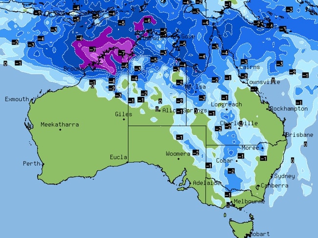
Upper Springbrook was lashed with 265mm within 24 hours, with Gray in Tasmania copping 207mm, 186mm in Tumbulgum, NSW, and 100mm in Brindabellas in the ACT.
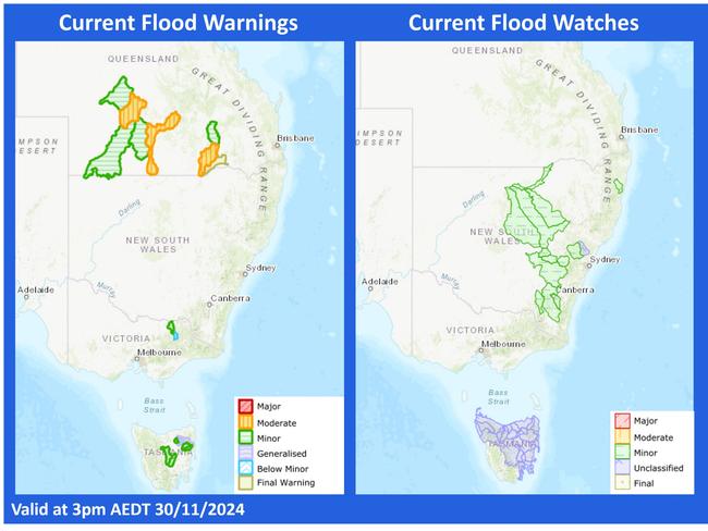
Flood warnings remain in place across the country, with minor warnings currently in place for the Warrego River, Paroo River, Barwon River in NSW, while there’s a flood watch for the south west catchments.
A minor flood warning has been issued for the Kiewa River in Victoria, while a moderate flood warning has been issued for the Bulloo River, Logan and Albert Rivers, Moonie River, Paroo River and Warrego River in Queensland.
Minor warnings are in place for the Bremer River and Warrill Creek, Lower Barcoo River and Upper Balonne River.
In Tasmania there’s a flood watch for the North, North West and North East while a moderate warning is in place for the South Esk River.
Minor warnings were issued for the St Pauls River, Macquarie River, North Esk River and Ouse and Clyde Rivers.
WILD SCENES IN AFFLUENT SUBURB
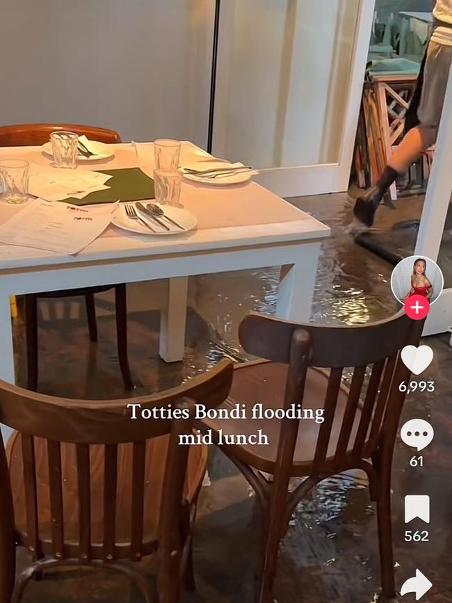
Video footage has captured the moment Totti’s in Bondi flooded, with staff desperately attempting to sweep the water out of the restaurant.
A diner can be seen sitting at the table despite the water covering the floor as staff do their best to deal with the situation.
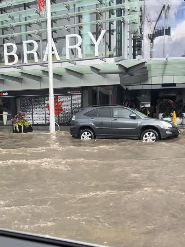
Another photo from Sunday shows water completely covering New South Head Rd in Double Bay just outside the Woollhara Library.
Water can be seen lapping at the tyres of a car, while it appears a sign cautioning a wet floor stands just outside the building.
“EPIC DOWNPOUR”
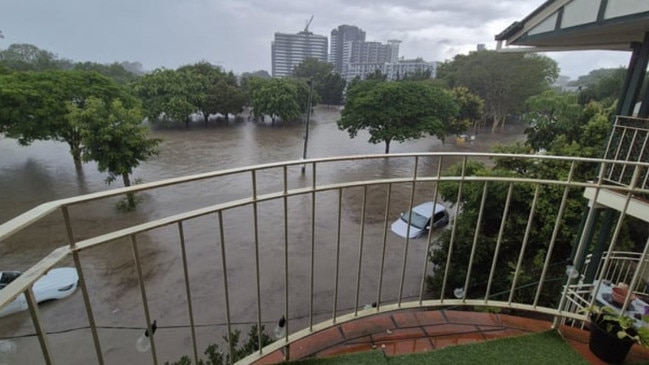
Streets were flooded in Brisbane and train services thrown into chaos across Sydney as wild weather on Sunday.
Brisbane Lord Mayor Adrian Schrinner said the “epic downpour” brought an average of 19mm of rain over just six hours across Brisbane, with peak falls reported in Holland Park West, with 92mm, and Bardon, with 73mm.
In a statement to X, Mr Schrinner said, during that time, there had been 11 severe thunderstorm warnings, 31 calls for assistance to the Queensland SES, and eight floor alerts issued to Brisbane creeks.
It comes after Transport for NSW warned commuters to expect delays between Cabramatta and Granville on the T2 Leppington and Inner West Line and on the T5 Cumberland Line, due to power supply issues between Harris Park and Merrylands.
The delays come after wild rains lashed the city on Sunday, with trains instead being diverted through Regents Park.
Passengers travelling to or from stations between Canley Vale and Merrylands were also advised to delay their travel or consider using other nearby modes of public transport. Trains on the T9 Northern Line were also delayed by flooding.
As the conditions continue over the latter-half of Sunday and into the week, emergency services have issued warnings for people to stay inside while the wet weather passes, which could result in flash floodings and dangerous driving conditions.
Over the weekend, an upper trough brought heavy showers and isolated thunderstorms over the northeastern part of NSW and the rest of the country.
Sydney weather update https://t.co/Z9fXykmtIX
— Lord of the Dance (@trashyhonky) December 1, 2024
In Sydney, flash downpours forced the closure of one lane of the arterial M5 motorway on Saturday afternoon, with water over the road affecting traffic at Bondi Junction, Petersham, Mascot and Moore Park, according to Live Traffic NSW.
Residents took to social media to share video from the snap storms which dumped rain intermittently across swathes of the city shortly after midday, with trees seen shaking in the wind the rain swept across quiet suburban streets.
The Bureau of Meterology has since cancelled its severe thunderstorm warning across parts of the east coast as the upper trough system weakened the threat of severe rain and storms, slightly improving conditions into Monday.
Despite the threat of thunderstorms slipping away, lashings of rain still battered the state overnight, with 140mm of rain recorded at Cudgera Creek in the Tweed Shire in three hours.
⛈ï¸âš ï¸UPDATE: SEVERE THUNDERSTORMS impacting parts of #Sydney, #Gosford, #Illawarra and others.
— Bureau of Meteorology, New South Wales (@BOM_NSW) December 1, 2024
HEAVY RAINFALL, DAMAGING WIND and LARGE HAIL all possible as these storms move over New South Wales.
Latest: https://t.co/YirEXV8NvBpic.twitter.com/VGSoOo0zMC
Wagga Wagga reported 24mm of rain by Saturday afternoon, with Forbes reporting 44mm of rain, and Dubbo collecting 31mm of rainfall in the span of 24 hours.
More than 60mm of rain has been recorded in Sydney’s CBD since Friday, with the SES expecting more than two month’s worth of rain to fall over the span of two days.
Intense rainfall blanketed the eastern coast of the country, covering the roads with water and causing flash flooding in parts of the country, including southern Queensland, northern Victoria, central NSW and Tasmania.
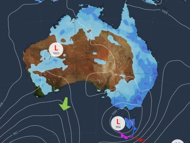
The most rainfall was recorded in Canungara in Queensland, which reported 110.8mm on Sunday morning, and 209mm of rainfall in Haughton over the span of 24 hours.
The Bureau of Meteorology said was due to the low pressure system, which causes “widespread rain, showers, and thunderstorms in many areas”.
These extreme and persistent rainfalls can lead to flash flooding caused by water spilling onto the roads and properties.
“That can lead to dangerous driving conditions with poor visibility and water over roads,” said meteorologist Angus Hines.
More than 900 calls were made to the SES since the start of the week, most of which were in regards to fallen trees, leaking roofs and sandbagging requests.
However, SES responded to nine flood rescue requests across the state, including in the Northern Rivers, Illawarra, western NSW and Sydney. More than 200 calls were made on Saturday, with 140 of the calls made in metropolitan Sydney.
Thankfully, everyone who required assistance was rescued safely, however, NSW SES state deputy commander, acting assistant commissioner Paul McQueen has issued a warning against driving through floodwaters, as they could have dire and sometimes deadly consequences.
“The message is simple – Please never drive, ride, or play in floodwaters,” he said.
“I also want to thank those who do the right thing and turn around to find another way. By doing this, you are saving our volunteers from being put into harm’s way.”
Despite the threat of thunderstorms lessening in parts of the country, acting assistant commissioner McQueen urged residents to have a plan ahead of potential flood warnings as the weeks progress.
“With more rainfall predicted over the summer period, travellers heading to caravan parks and resorts in low lying areas should have a plan and prepare for possible heavy rain, which can lead to flash flooding and riverine rises,” he said.
“You don’t know what condition the road underneath the water is in and can’t see hidden obstacles and debris under the surface. Flooded rivers may also contain hidden debris, snakes, spiders, chemicals and sewage.”
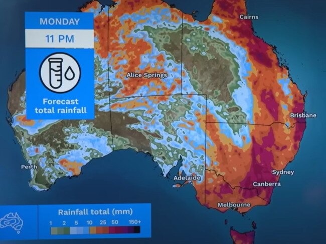
Looking forward, the week looks a little less wet and gloomy for those on the eastern coast, with the threat of severe thunderstorms downgraded in parts of NSW as the low trough moves the storms offshore.
Residents in Sydney can expect a partly cloudy day with a medium chance of showers in the afternoon and early evening. There is a chance of a possibly severe thunderstorm developing in the afternoon, with a maximum temperature of 29C.
Melbourne will reach a top of 24C on Sunday, with a medium chance of showers developing in the afternoon and early evening. The day is expected to be partly cloudy, with the chance of a thunderstorm in the nearby hills in the late afternoon and early evening.
A moderate fire danger has been issued for the state.
It will be a cloudy day for people in Brisbane, with a maximum temperature of 28C and a high chance of showers, becoming less likely in the late afternoon. There’s also a chance of a possibly severe thunderstorm developing in the city, with lights winds reaching top speeds of 20km/h about midday.
Residents in Perth can expect a partly cloudy day with the chance of showers in the late afternoon and early evening and a maximum temperature of 24C. A high fire danger has been issued for the northern and southern parts of Swan Inland, with a moderate fire danger warning issued to the southern and northern parts of the Swan Coastal South.
Adelaide will record a medium chance of rain in the morning, which is set to clear by the afternoon. People can expect sunny conditions in the afternoon, reaching a top temperature of 26C.
It will be a partly cloudy day for Canberra, with a possible thunderstorm in the morning, potentially becoming severe in the afternoon, followed by a medium chance of rain and a maximum temperature of 26C.
Hobart will have a partly cloudy day with a high chance of rain, which will likely clear in the morning. Residents can expect a windy morning with a top temperature of 26C.
There is a medium chance of showers for Darwin on Sunday morning and afternoon, reporting a partly cloudy day with the chance of a thunderstorm and a top of 33C.


