Cold front to cool soaring temps amid fears of more lightning fires along NSW-Victorian border
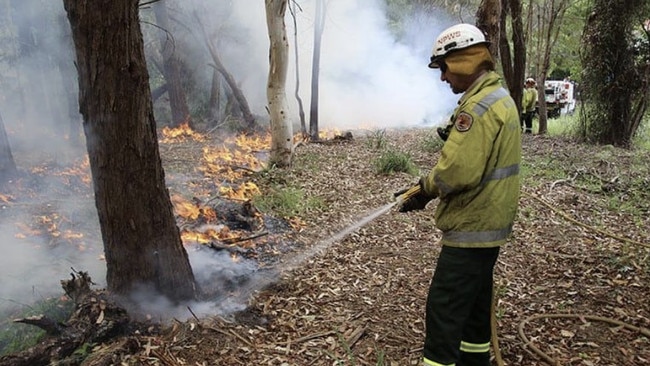
Firefighters are battling unpredictable weather as residents in one state have been warned not to wait to be told when to leave.
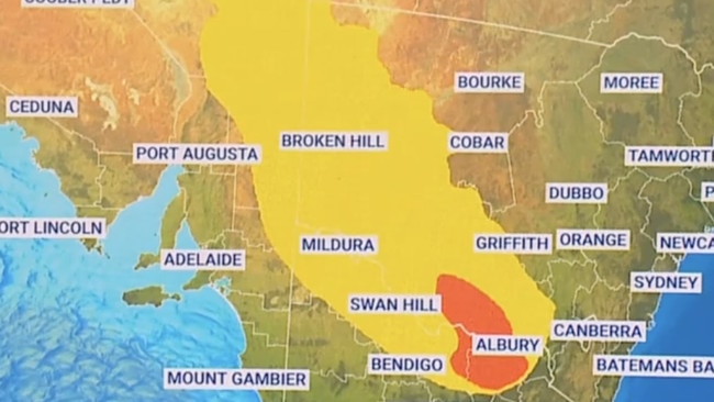
A cold front is forecast to ease scorching temperatures as firefighters battle dozens of blazes across NSW and Victoria.
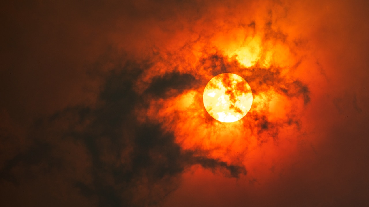
Sydney sweltered through its hottest ever start to October on Sunday, with the mercury climbing to 37C, while those in eastern Victoria were on edge with “challenging” conditions in the Gippsland region.
NSW fire services had to contend with 85 fires over Sunday night.
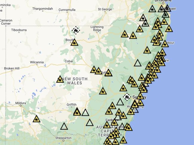
NSW Rural Fire Service (RFS) has issued a watch and act alert for Home Rule in the Cudgegong LGA in the state’s mid west.
“RFS firefighters are working to contain a grass fire burning in the vicinity of Henry Lawson Drive and Drews Lane towards St Fillans Rd, approx 11km SW of Gulgong,” a spokesperson said.
Residents who are south of Home Rule have been told to prepare to leave as the grass fire burns out of control.
Meanwhile, two watch and act alerts have been put in place in Victoria for fires burning on Duffy Rd at Briagolong that is not yet under control.
Cobbannah, Glenaladale, Moornapa and Briagolong are all affected by the fire and authorities are strongly recommending that residents prepare to evacuate and monitor emergency warnings.
Vic Emergency said residents must “act now to protect your life” and the Bairnsdale-Dargo Road is now open as an escape route.
“Prepare to evacuate immediately and leave as soon as you are ready, as roads will become busy as people leave,” Vic Emergency warned.
“When you are ready, you should leave immediately. Don’t wait to be told when to leave.”
While Monday’s temperatures are expected to be slightly cooler than over the weekend, firefighters in NSW and Victoria will have to battle unpredictable weather, according to Sky News meteorologist Bradlyn Oakes.
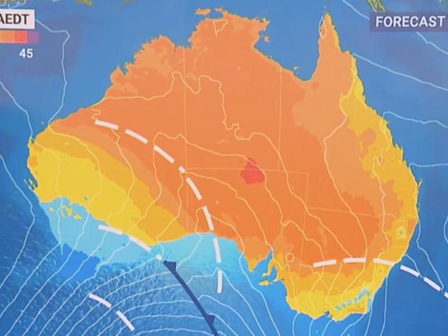
She said thunderstorm activity across Victoria, NSW and South Australia could lead to lightning strikes, in turn sparking more fires.
“Now there‘s a bit more moisture out there for tomorrow, which is good but today, the main hazard is going to be the fact that we’re going to see dry lightning and that could spark fires,” Ms Oakes said.
“And so we do have extreme fire danger across the country today into tomorrow.”
The thunderstorm activity will run from NSW west down into Victoria, with the area around Albury-Wodonga to be the most impacted.
Those in Mallee, in Victoria’s northwest, are under a total fire ban as temperatures are expected to climb to 35C on Monday.
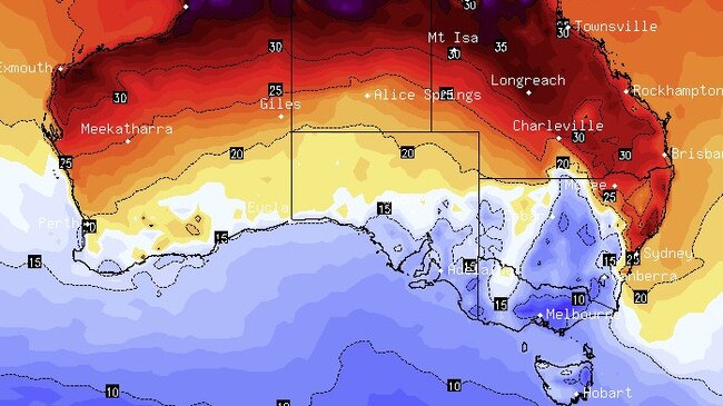
The rest of the week’s weather will offer a reprieve from sweltering conditions and high bushfire danger in Victoria, with a “very strong cold front” to make its way through from Tuesday.
“Temperatures are going to cool across many of our southern and southeastern capitals over 10 degrees in just a couple of days,” Ms Oakes said.
“We‘re going to see substantial wet weather build in to the Gippsland region, really good for those fire conditions there … we are going to see the potential for 100 or 150 or possibly close to 200mm of precipitation fall in that region.”
The news isn’t as good for NSW residents, with hot conditions set to remain in place until Wednesday afternoon.
Aside from the dry lightning, conditions are expected to be “a little bit nicer” as temperatures drop off from Sunday’s sweltering conditions, especially in Gippsland where those worrying fires are raging.
“In some areas of Gippsland we have seen temperatures cooled dramatically and those winds have really gone down through the night into our morning … So we‘re watching as our fire weather conditions are a little bit better but there’s still going to be quite a bit of heat out there today,” Ms Oakes said.
Bushfires weren’t the only thing keeping firefighters busy on Sunday, with a large tip fire kicking off at a landfill facility in central NSW.
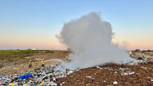
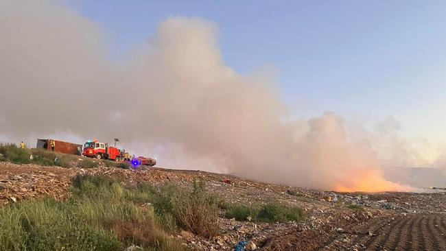
Firefighters worked to extinguish the fire at Gregadoo Waste Management Centre, south east of Wagga Wagga, before bringing it under control on Sunday evening.
Residents around Gregadoo and Forest Hill were advised by the Rural Fire Service that they should close their windows and doors as they may be affected by the smoke.
Here’s a look at the weather across the eastern cities:
MELBOURNE
Melburnians should prepare for temperatures to dip from Tuesday as a cold front sets itself up for the rest of the week.
Temperatures will hit a high of 23C on Tuesday before hovering between 10C and 15C until Sunday.
Along with the cooler temperatures, Victorians could be in for a soaking with the possibility of motre than 100mm to fall in parts of the state and more than 50mm expected in Melbourne.
SYDNEY
Sydneysiders will have to endure three more hot days before a cold front sweeps in to cause a drop in temperature.
Temperatures are expected to reach 24C in the city and 29C in the west on Monday, lower than they were on the weekend when the mercury climbed to the mid and high 30s across parts of the city.
However, the reprieve isn’t expected to last long, with Penrith to suffer through a scorching 37C day on Tuesday.
Tuesday’s heat is also set to bring extreme fire danger, with Sydney, the Hunter, the majority of the state’s west and the far south coast all having fire warnings in place.
The cold front is set to make its way through on Wednesday afternoon when there’s an 80 per cent chance of showers in the afternoon and evening.
BRISBANE
Those in Queensland’s southeast will be lapping up the warmth as mild spring weather makes itself at home this week.
Brisbane residents will enjoy highs of 28C throughout the week along with partly cloudy weather.
Thursday is set to be Brisbane’s most rainy day, with a 50 per cent chance of a thunderstorm.

Wrestling great ready for ‘Brisbane Brawl’
Professional wrestling and acts taps into the ‘creative space’ that AEW star Adam Copeland thrives on.

Sliding City happy to be home
Melbourne City hopes returning to AAMI Park on Saturday will lead to a return to winning ways.