NSW weather: BOM says coldest day in 25 years
NSW will shiver through the coldest day in a quarter of a century with snow expected to fall across the state.
NSW will have the coldest day in a quarter of a century with widespread snowfall falling across the state.
In Sydney, the mercury will barely reach double figures with a top temp of 10C expected in the west and 11C in the east.
Bureau of Meteorology forecaster Helen Reid said the cold snap is not recording breaking but is significant.
“Generally speaking it will be the coldest day in years for a lot of places. It is expected to be the coldest day in 25 years for Sydney,” she said.
“Also in Scone it will be the coldest day since 1996 – so it is the coldest day for a long time but it is not quite record breaking.”
The Bureau of Meteorology has warned of cold temperatures, showers and strong south-westerly winds during Thursday and Friday.
The forecast for Armidale includes snow and the snowfalls have already been reported in the Northern Tablelands town of Guyra.
Snow levels in NSW could drop to 800m, and could possibly fall to as low as 500m.
Snow may conjure up Winter Wonderland images, but with extreme drops in temps, dramatic wind-chill & icy road conditions (just some of the impacts) it must be treated with respect when it comes to keeping safe. Follow @QldFES@QldPolice advice. #QLDweatherhttps://t.co/iAMBKdJN4xhttps://t.co/JSWkLkRiHB
— Bureau of Meteorology, Queensland (@BOM_Qld) June 8, 2021
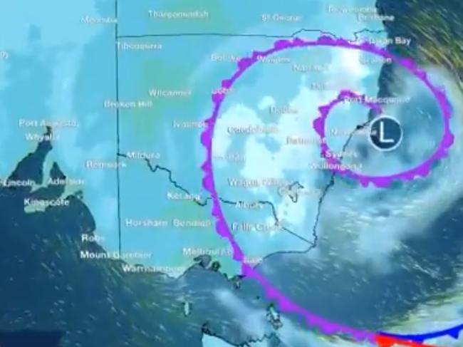
A low pressure system over central New South Wales will enhance the cool to cold westerly flow over southern Queensland today. It is predicting snow or sleet at times about the higher terrain on the Granite Belt.
The cold snap is due to a pool of cold air direct from Antarctica.
The bureau has warned that temperatures could plunge 10 degrees below average over the next day or so.
Up to 20mm of snow could fall over areas that may only get a dusting once every few years.
Meanwhile, the cold front will mean Queensland will shiver through a series of cold mornings, with temperatures as low as 6C expected on Thursday morning in Brisbane.
National forecast:
Elsewhere, much of NSW and the ACT will experience a significant drop in temperatures over coming days, with some areas expected to be more than 10C below average and many areas expected to be more than 5C below average.
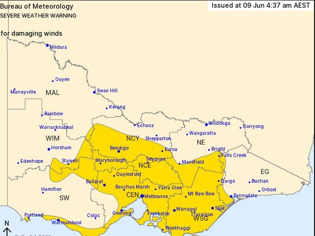
Meanwhile, thousands of residents in Victoria are being told to brace for damaging winds during Wednesday, as a low pressure system moves over central parts of the state.
A Bureau of Meteorology warning for people in Central, North Central, West and South Gippsland, and parts of East Gippsland, South West, Northern Country, North East and Wimmera forecast districts said another low would “rapidly deepen” near the east Gippsland coast on Wednesday night.
“Damaging southerly winds, averaging 50 to 60km/h with peak gusts of 90 to 10 km/h, are possible about the coastal fringe and about elevated areas in the west early Wednesday morning,” the warning said.
“Winds are then expected to tend south-easterly and extend over central and eastern parts of the warning area during Wednesday afternoon and evening, including the Melbourne metropolitan area.
“Winds are likely to average 60 to 70km/h overnight into Thursday about the southern Gippsland coast and the central and Gippsland ranges, with peak gusts reaching around 110km/h.
“Blizzard conditions are possible about the alpine peaks late Wednesday and Thursday morning.”
Sheep graziers in South Australia’s Mount Lofty Ranges, Eastern Eyre Peninsula, Yorke Peninsula, Kangaroo Island, Flinders, Mid North, Riverland, Murraylands, Upper South East, Lower South East, North West and North East Pastoral forecast districts have been warned about cold temperatures, showers and southerly winds.
“There is a risk of losses of lambs and sheep exposed to these conditions,” the bureau said.
A similar warning is active for sheep graziers in Western Australia’s Central West, Lower West, South West, Great Southern and Central Wheat Belt forecast districts, where north-easterly winds, showers and cold temperatures are expected on Wednesday.
A severe weather warning is active for people in South West and parts of Lower West Western Australia, where higher than usual tides and “squally weather” are forecast for Wednesday and Thursday.
The bureau is warning the high tides could cause flooding of low-lying coastal areas, and damaging surf conditions could cause significant beach erosion.
“Damaging winds with gusts to 90km/h are possible and could cause damage to homes and property on Wednesday night and Thursday morning,” a warning said.
In Tasmania, a severe weather warning for damaging winds is active for people in Furneaux Islands, North East and parts of East Coast, North West Coast, Central North, Central Plateau and Midlands forecast districts.
Winds averaging 60 to 70km/h with peak gusts of 90km/h are expected to develop during Wednesday afternoon but should ease by Thursday.

2500 super members slugged unwanted fees
A major superannuation fund that incorrectly charged members for insurance premiums they didn’t want has divided an online community with its response.

Man arrested for alleged murder of woman
A man has been arrested following investigations into the suspicious death of a woman who was found dead in her home.