Australia weather: Monsoon trough hit Australia’s north, as WA and SA brace for heatwaves
Another tropical low forming off the north Queensland coast could enhance an already unforgiving monsoon trough that has dumped accumulated falls of up to 300mm.
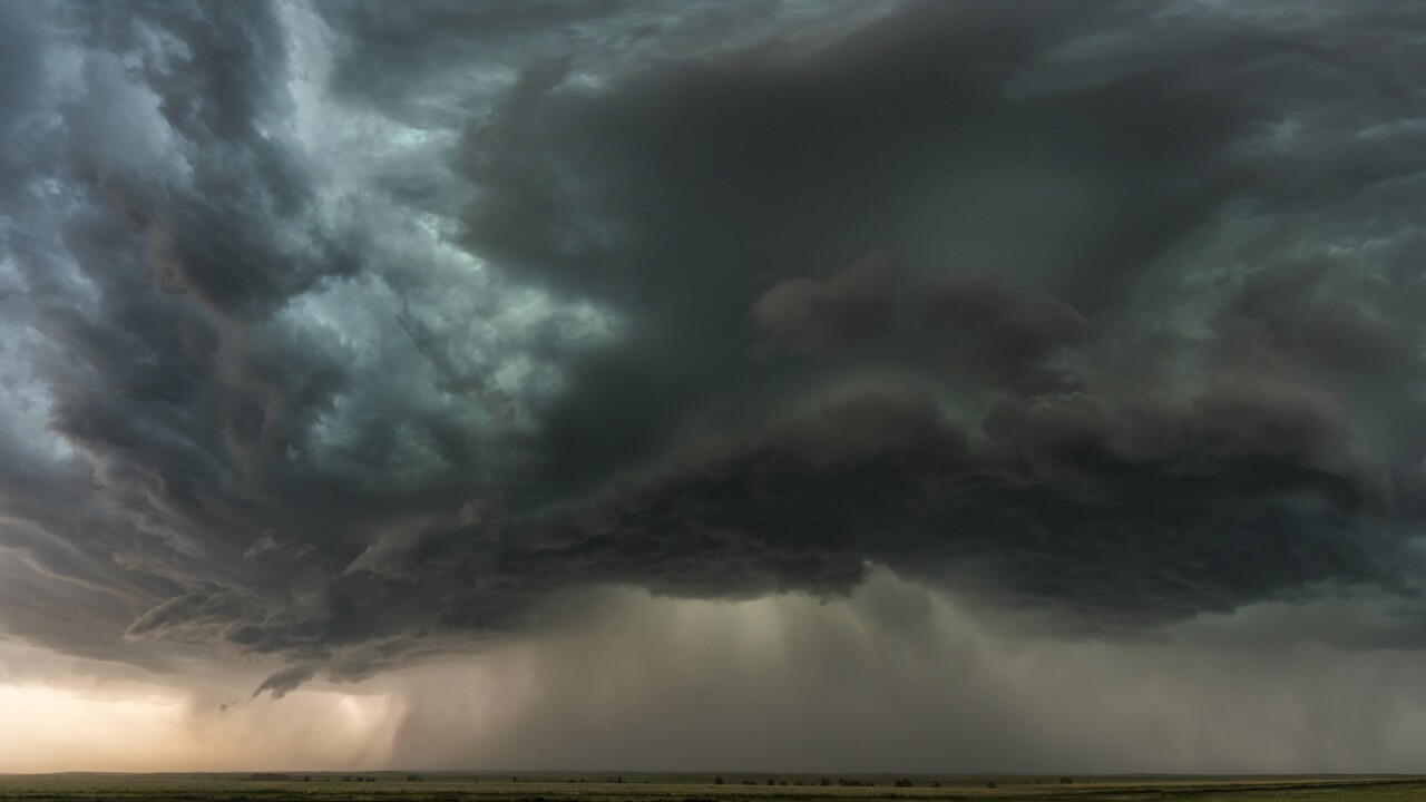
Another tropical low forming off the north Queensland coast could enhance an already unforgiving monsoon trough that has dumped accumulated falls of up to 300mm in some areas since Thursday.
Since 9am on Saturday parts of the north tropical coast have received over 100mm of rain, however the worst is on its way for the region still reeling from Cyclone Jasper.
The Bureau of Meteorology’s Felim Hanniffy said the far-north can expect quite a bit of rain for the coming week.
“Monsoon showers and storms are expected for much of this week, with a large enhancement on Monday as that weak tropical low forms off the coast,” Mr Hanniffy said.
“We will definitely see falls of over 100mm in 24 hours in some areas, with up to 250mm not out of the question.”
Most areas in line of the monsoon trough have recorded at least 50-100mm of rain in the last 24 hours, with over 100mm in isolated areas such as Innisfail and north of Cairns.
Minor flooding across the north tropical coast rivers that was seen on Friday to Saturday could renew over the next few days, particularly with the development of the lows.
“The main risk with the lows is that it can enhance rainfall.
“The primary low is the one off the Northern Territory and will remain a pretty deep system even inland, showing the hallmarks of Cyclone Ellie we saw last year with a slow moving system.”
Mr Hanniffy said there was a very low chance for this newly developing low to produce any cyclone activity.
The monsoon system is set to last to the end of next week, lashing the region with up to 100mm a day in some spots.
“Monday we will see some of those higher totals due to that low enhancing the activity.
“On Tuesday and Wednesday we’ll get back to the more daily rainfall around 50 to 80mm with isolated higher amounts,” Mr Hanniffy said.
The sunshine state will not be living up to its name this coming week as the south-east can also expect a wet start with showers beginning on Monday.
“It will be an unsettled week for the south-east, especially Monday afternoon and into Tuesday morning,” Mr Hanniffy added.
Towards the middle of the week shower activity is expected to die off, however another system from the west may stir up more showers and thunderstorm activity.
“There are two systems of note in terms of the south-east, the second bringing isolated thunderstorms and rain in the latter part of the week.”
Mr Hanniffy said there could be some sizable totals with 50-100mm possible, particularly in northern New South Wales and parts of the boarding ranges in south Queensland.
“Showers will never really feel too far away this week, there will be less of them on Wednesday before that weather system in the west comes through,” he said.
As the monsoon season sets to descend on northern Queensland, a major concern will be how the renewed downpour impacts regions still recovering from the serious weather events caused by ex-tropical Cyclone Jasper.
Late last year, the slow-moving category 2 storm caused largescale flooding, power outages, and landslides in the state’s far north -- areas which could soon be lashed by severe winds and heavy rains.
The Bureau of Meteorology’s senior meteorologist Angus Hines said the monsoon could see Queensland, the Northern Territory and Western Australia could be hit with 100 to 300mm of rain.
While the rainfall is “seasonal,” the excess rain is worrying for towns north of Cairns and around the Daintree area, which “bore the brunt” of the severe weather from Cyclone Jasper.
“(They’re) still in recovery mode in some areas. So even though we’re seeing some more rainfall... it’s not really wanted or welcome rainfall as it could impact or set back some of those recovery efforts,” he told Nine.
He added that the monsoons will like “stick around for a while,” however the daily totals will likely vary.
“That could be up to 50 or 100mm through the first half of this week (and) it’s likely to linger into the second half of the week as well,” he said.
“It’s not going to be torrential rain every single day, but we do see that risk of wet weather.”
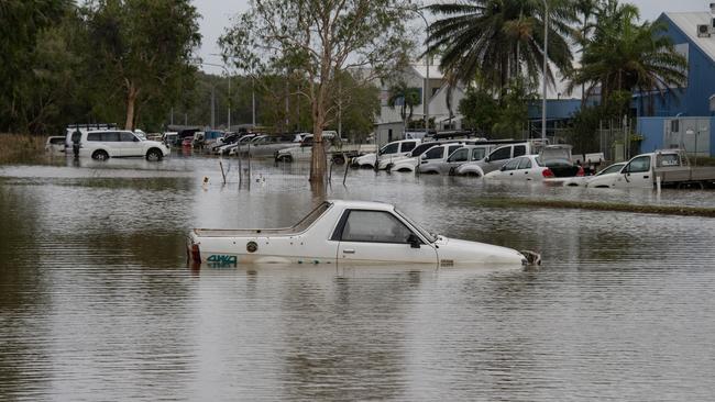
Queenslanders have been warned to prepare for the potential of flash flooding as a monsoon trough sweeps across the state’s far north, bringing a new wave of heavy rain to the already drenched ground.
On Saturday, Queenslanders were told to prepare for the potential of flash flooding, with a monsoon trough leading to falls of between 50 to 100mm, with the deluge likely to continue into the week.
“More widespread heavy rainfall is likely to develop later in the weekend as the monsoon strengthens,” the BOM warned.
“Significant river, creek, and stream rises are likely with heavy rainfall, with possible minor to major flooding across the Flood Watch area during the next week.”
Listen up, Far North Queensland!
— Qld Fire & Emergency (@QldFES) January 13, 2024
Slow moving, severe storms are likely to produce heavy rainfall overnight in parts of the far north, including Atherton, Millaa Millaa, Ravenshoe and Mount Garnet.
Flash flooding is a risk in these areas, so, if you are impacted by heavy… pic.twitter.com/uYiCAO2Csk
A flood watch is also in place in the Northern Territory’s north Western, with concerns catchments could quickly be overrun, with further heavy downpours forecast for later this week.
Although the trough is not expected to evolve into a tropical cyclone, daily rainfalls of 50 to 150mm, plus isolated heavier rains could leave to major flooding events over the next coming days.
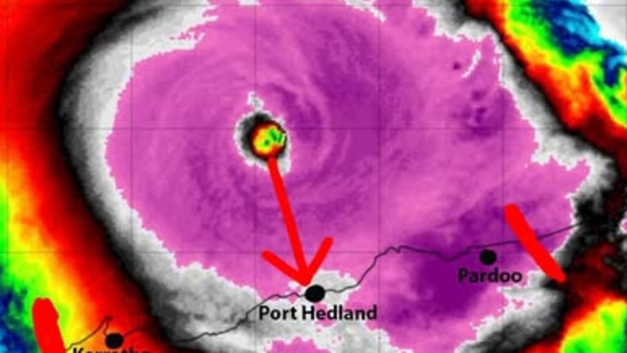
It comes as a low pressure system is forecast to develop southwest of Darwin throughout Sunday, leading to storms, plus heavy rain and winds.
The Bureau warned that “many roads, and possibly primary and secondary highways may be affected,” with the danger that some communities and homesteads could become isolated due to rising water levels.
Residents have been urged to check road conditions before travelling, and to never drive into flood waters.
Meanwhile, inland parts of South Australia and Western Australia have been urged to brace for a heatwave.
In Western Australia, maximum temperatures could soar into the mid-forties across of the north of the state, and into the mid-thirties across the far south.
Large parts of #WA are forecast to have well above average summer temperatures today.
— Bureau of Meteorology, Western Australia (@BOM_WA) January 13, 2024
Heatwave Warnings are in place for large parts of the state, meaning today is not an isolated hot day.
Latest: https://t.co/G0FGJFlpQKpic.twitter.com/FUz8nUjAj6
Severe heatwave condition are expected to stretch into the week ahead, with key areas of concern including the Perth metro area, as well as Bunbury, Katanning, Meekatharra, Mount Magnet, Manjimup, Margaret River, Narrogin, Northam, and Paraburdoo.
A severe heatwave warning is also in place for the North West Pastoral District in South Australia. Temperatures could soar into the forties across the APY Lands and Oak Valley, with the hot conditions forecasted to last until Monday.
Warning after 60 rescued in major flooding
Emergency services are continuing efforts to rescue stranded residents and assist in recovery operations.

Reds star staying patient in comeback bid
With a ‘weird’ 2024 behind him, Queensland Reds co-captain Liam Wright is eager to return from a shoulder injury that has sidelined him since July.