By Angus Dalton
This season was supposed to mark the return of the glorious Sydney summers of old that have been choked by Black Summer smoke, ruined by COVID lockdowns and battered by La Nina rain in recent years.
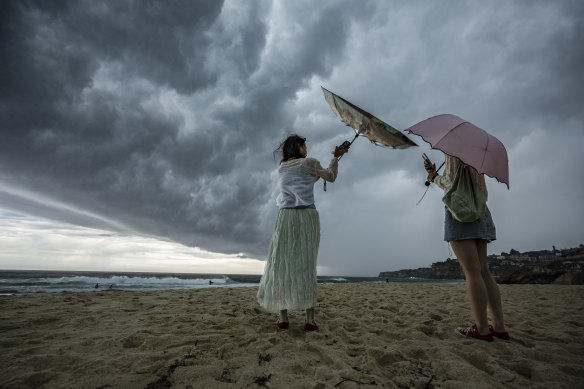
And while NSW has largely dodged the deadly storms and floods that have lashed Queensland and Victoria, Sydney has often fallen under the shadow of rain clouds many expected El Nino would banish from summer skies.

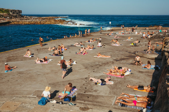
Beach days for the rest of January are under a cloud, with above-average rain expected for NSW.Credit: Wolter Peeters
Intense storm cells over the Christmas period caused flash flooding that trapped 20 Sydney drivers. The rain flushed harbour beaches with dangerous levels of pollution and drizzle dampened Christmas lunches and New Year’s Eve crowds.
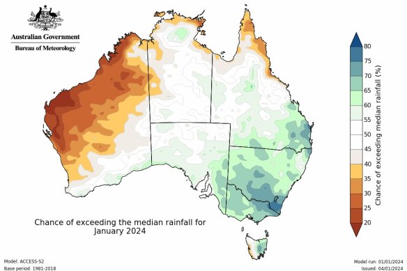
Now Sydney is in for another wet week. For the rest of January, there’s a 60 to 80 per cent chance of above-average rainfall for NSW and much of the eastern seaboard, according to the Bureau of Meteorology.
“It’s really quite exceptional rainfall that we’ve seen in the last few weeks across Queensland, New South Wales and Victoria,” Dr Andrew King, a Melbourne University climate scientist, said. “It’s probably not really what we would expect during an El Nino year.”

The bureau expects above-average rainfall across NSW in January and for the rest of summer.Credit: The Bureau of Meteorology
El Nino and La Nina are two sides to a climate system called ENSO (the El Nino-Southern Oscillation). When ENSO flips to La Nina, water off Australia’s north-east warms, increasing the likelihood of storms and rain. In El Nino, the waters cool, so there’s less moisture rising into the atmosphere and greater chances of dry, hot days.
But the temperature hasn’t cracked 30 degrees at the Sydney Airport or Observatory Hill weather stations in almost a month. Sydney’s heat is only about 1.3 degrees above average so far for January, and the clouds have kept away the 40-degree scorchers that had fires flaring around NSW in spring.
So what’s bringing the rain when El Nino was supposed to conjure a cloudless summer?
El Nino is not a summer child
“I think it’s first worth noting that the El Nino influence on Australian climate is really at its strongest in late winter and spring, rather than in summer,” King said.
“During El Nino events, we’d expect to see drier warmer springs, but by summer, the link wears off a bit.”

Heat soared in Sydney in early spring and El Nino contributed to the driest September on record. Credit: Dion Georgopoulos
El Nino’s spring strength was apparent last year – the climate driver contributed to a sapped season, which included the driest September on record. But the system’s drying effect loses steam as summer sets in and much of Sydney’s rain comes from short, intense thunderstorm downpours, said King.
In any case, El Nino only increases the probability of dry, hot days. Whether these eventuate is still a roll of the dice.
Sticking with that metaphor, CSIRO climate extremes researcher Dr Carly Tozer said you could imagine a six-sided dice which, in normal conditions, has two faces corresponding to wet weather, two faces corresponding to dry, and two corresponding to neutral.
“In an El Nino, you might change two of those faces to dry,” Tozer said. “So you increase the chance of dry weather, but you still have an average and a wet face. You still could roll on wet.”
Does Sydney dodge most of El Nino’s effects anyway?
New analysis led by Tozer also found the effect of El Nino and La Nina on Sydney’s rainfall is weak.
She and her colleagues analysed spring rainfall data in 5-kilometre squared grids. Overall, El Nino increased the chance of dry days and La Nina boosted the chance of rainfall, as expected. But the detailed picture is more nuanced.
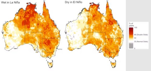
Tozer found that the effect of these climate drivers was strong west of the Great Dividing Range. But along NSW’s coast they barely shifted the odds of rainfall.

Shades in darker orange show areas where spring rainfall was strongly influenced by El Niño and La Niña, according to Tozer’s research. For Sydney and much of NSW’s coast, the effect was weak. Credit: Dr Carly Tozer, CSIRO
The chance of spring rainfall during La Nina only increased from 33 to 38 per cent in the Sydney region, for example, whereas in parts of the state’s interior, the chance of rain doubled.
Tozer said that high rainfall on the coast is mostly dependent on local winds blowing ocean moisture onto land – and those winds aren’t affected much by La Nina or El Nino.
“The eastern seaboard is a curious place – rainfall’s relationship with La Nina and El Nino is not as strong in Sydney,” she said. “You’ve got to think about where you’re actually located.”
What’s causing the rain?
Aside from natural weather variability, there are two factors that could be sending rain clouds and horror storms spiralling towards Australia’s east.
One is a marine heatwave swamping the seas off south-east Australia – one of the fastest-warming areas of ocean under human-caused climate change – that’s sending moisture up into the atmosphere off our shores.
Concerned scientists have described the heatwave as “an underwater bushfire that can’t be extinguished”.
In its latest climate update, the bureau noted global ocean temperatures are at their hottest on record and above-average heat in the Tasman Sea could be intensifying summer rain.
Another important climate driver to consider is the Southern Annular Mode (SAM), which is now in a positive phase that generally summons rain to southern Australia.
During a positive SAM, a band of westerly winds and low-pressure systems to the south of the continent contract towards Antarctica. In response, high-pressure systems settle over the Tasman.
“In the Southern Hemisphere, we have winds around that high pressure that move in an anti-clockwise direction,” King said. “The winds to the north of the high-pressure system are moving from east to west, across the sea towards the coast of New South Wales and Queensland.
“The ocean is incredibly warm to the east Australia at the moment. [Those winds] are picking up more moisture, increasing the rainfall.”
The Examine newsletter explains and analyses science with a rigorous focus on the evidence. Sign up to get it each week.