- Updated
- National
- WA
- Extreme weather
Cyclone Zelia: Everything WA residents need to know
By Heather McNeill
The Pilbara region in Western Australia is bracing for Severe Tropical Cyclone Zelia to make landfall on Friday as a category 5 system.
It is moving south-east at the slow speed of 7km/h, which is allowing it to gather intensity as it nears the coast of Port Hedland, the epicentre of Australia’s iron ore industry.

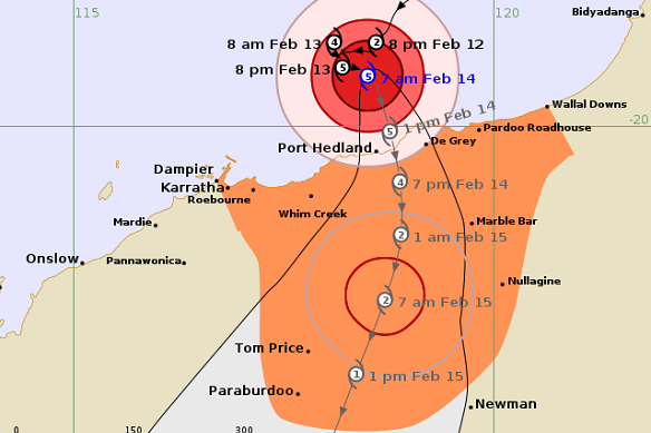
The predicted path of Severe Tropical Cyclone Zelia as of 7am on Friday.Credit: Bureau of Meteorology
When is Cyclone Zelia expected to hit?
Severe Tropical Cyclone Zelia is expected to make landfall slightly east of Port Hedland on Friday afternoon – between about 2pm to 4pm according to the Bureau of Meteorology’s Angus Hines – as a category 5 system.
Destructive winds are forecast from as early as Thursday night as the system continues to track closer to the Pilbara coast.
Rainfall and flooding is expected to be intense in the eye of the storm and to its east. Destructive wind gusts of up to 290km/h are forecast, with up to 500 millimetres of rain to fall in the worst-hit areas.
Significant storm surges could occur in coastal areas, particularly if the storm crosses during high tide (which happens every 12 hours).
Where is it expected to impact?
The system’s path has been described by authorities as erratic and unpredictable.
The Bureau of Meteorology previously forecast the cyclone would pass over the Pilbara somewhere between Karratha and De Grey, but a new forecast on Friday morning put the crossing almost directly on top of Port Hedland.
Throughout Thursday, the bureau’s predicted path showed the system moving west, potentially passing closer to Whim Creek, before it swung back east overnight.
The dangerous system rapidly intensified into a category 5 storm on Thursday after the “perfect ingredients” of warm sea temperatures, moisture, low-level winds and a slow-moving system combined overnight.
What has the WA state government said?
The Department of Fire and Emergency Services has issued a watch and act alert for the Pilbara between Dampier and Eighty Mile Beach. The alert was upgraded to an emergency overnight, which requires residents to remain indoors for their own safety.
The Port Hedland port, schools, and major roads accessing the region have all closed in preparation for destructive winds and major flooding.
Evacuation centres have been set up in Port Hedland and Karratha.
A DFES team of more than 50 personnel is in the Pilbara ready to assist in any rescue and recovery efforts. Flood boats have also been sent to the region, with major widespread flooding expected.
What is a category 5 cyclone?
A category 5 system is the most severe cyclone rating in Australia. Storms this strong rarely make landfall.
It typically will bring destructive wind gusts of more than 280km/h, with a mean wind speed of around 200km/h. Damaging winds can impact areas several hundreds of kilometres away from the eye of the storm. Sea levels can also surge.
The systems are extremely dangerous and cause widespread destruction to buildings and vegetation.
The last category 5 cyclone to make landfall in Australia was also in the Pilbara region. In 2023, Tropical Cyclone Ilsa passed through Pardoo as it made its way inland. Thankfully, it passed over mostly sparsely populated land. It destroyed a roadhouse, one of the few buildings in its path.
How long is Zelia expected to last?
Severe Tropical Cyclone Zelia is now a category 5 system and is expected to make landfall on Friday afternoon.
The bureau predicts the system will maintain its intensity as it makes its way onto land. It is then predicted to weaken to a category 2 system around 12 hours after it crosses the coast as it continues to track south.
It’s then expected to fizzle to a category on Saturday afternoon near the mining town of Tom Price, before finally weakening to a tropical low as it heads south-west of Newman.
Start the day with a summary of the day’s most important and interesting stories, analysis and insights. Sign up for our Morning Edition newsletter.