By Heather McNeill
The West Australian mining towns of Karratha and Port Hedland are both at risk of a “direct impact” from Severe Tropical Cyclone Zelia, which is expected to make landfall on Friday afternoon.
The Bureau of Meteorology said the category five system’s path remained unpredictable and problematic, with thousands of residents along the Pilbara coast bracing for its impact.
It’s expected to generate wind gusts up to 290km/h, and dump more than 500 millimetres of rain in the worst affected areas. High tides and already overflowing river catchments could also compound major flooding in coastal areas prompting roads into the region to be closed.
“It doesn’t get any worse than that, that is the most powerful tropical cyclone you can get,” senior meteorologist Angus Hines said.
“It’s an organised and powerful tropical cyclone that will play a significant role in the weather across this part of the country over the next few days.”
The Bureau of Meteorology expert warned the storm, currently 120 kilometres off the Pilbara coast, was expected to cross the coast between Karratha and De Grey, further west than earlier predicted, but that areas east of the system’s eye would cop the brunt of the destructive weather.
Significant flooding is expected, with the Great Northern Highway and North West Highway closed. The Port Hedland port – the largest export tonnage port in the world – was closed on Wednesday along with local schools.
Qantas and Virgin Australia have cancelled flights in and out of Port Hedland and an evacuation centre has been set up at JD Hardie Youth and Community Hub.
Bureau spokesman Dean Narramore told 9News Perth “all the ingredients came together” overnight for the cyclone to rapidly intensify from a category 2 to category 5 storm within 12 hours.
“Right now, we’re looking at it crossing as a category 5 system to the west of Port Hedland, that puts them in the onshore flow, so the winds, rain and storm surge all coming in off the ocean, they’re in the most dangerous part of a tropical cyclone, that’s where we see the worst conditions,” he said.

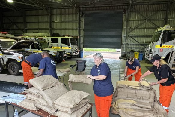
SES volunteers providing the public with sand bags in preparation for TC Zelia. Credit: SES
“It’s a very large and intense system, so even if you are not right over where it’s going to cross, you’re still likely to see destructive winds, torrential rain falls and storm surge.”
Narramore described the situation as dangerous.
“It’s going to maintain that intensity today, tonight and through Friday and unfortunately continue to be a category 5 system as it crosses the coast on Friday afternoon into evening with very devastating impacts,” he said.
The Department of Fire and Emergency Services has issued a watch and act alert for large sections of the Pilbara, including the 18,000 residents in Karratha and 15,000 residents in Port Hedland.
“There is great uncertainty as to where and when the very destructive inner core of the cyclone will cross the coast,” the alert warned.
“Zelia could cross the east Pilbara coast on Friday or it could move further west and cross the west Pilbara coast on Saturday.”
DFES Commissioner Darren Klemm said emergency services were preparing for some areas to receive between 200 and 300 millimetres over a 24-hour period.
“DFES has significantly boosted its resources in the Pilbara and the Kimberley with additional personal into our incident management teams in both Broome and Karratha as well as operational on-the-ground personnel, rapid damage assessment teams into Nullagine and Marble Bar and in the Pilbara more generally,” he said.
“The intensity of Tropical Cyclone Zelia means there is a significant threat to lives and property and I urge people to follow the directions of emergency services.”
Klemm said DFES was also bringing in flood boats, planes and a rescue helicopter.
Road access to the North West, including the North West Highway, is expected to be impacted for up to a week due to extensive flooding.
“I think people should expect that some of these major highways are going to be closed and potentially for up to a week or potentially even longer depending on any damage,” Klemm said.
Remote communities are being stocked in preparation for being temporarily cut off from supply chains. Marble Bar, Nullagine and remote Aboriginal communities in the east Pilbara have declined to be evacuated, instead choosing to protect in place.
The last category 5 system to make landfall in Australia was Severe Tropical Cyclone Ilsa in April 2023, which also crossed the Pilbara coast. However, sparsely populated land near Pardoo bore the brunt of the storm and its 225km/h wind gusts.
Pardoo Roadhouse, one of the few buildings in its path, was destroyed.
Start the day with a summary of the day’s most important and interesting stories, analysis and insights. Sign up for our Morning Edition newsletter.