By Ashleigh McMillan, Angus Delaney and Roy Ward
Victoria’s heatwave, which kicked off in the state’s north-east on Thursday, is expected to stretch out until Tuesday as fires in the Grampians and Little Desert National Parks continue to burn and thunderstorms have caused damage around Geelong.
A “leave immediately” warning was issued for the Mirranatwa area near the Grampians National Park bushfire and for Nurcoung on the southern border of the Little Desert National Park bushfire on Sunday as temperatures soared past 40 degrees in parts of northern and western Victoria and Melbourne.
Residents of Rocklands, Balmoral and Vasey, all west of the Grampians, were issued with a “take shelter now” warning on Sunday evening as a bushfire at Vasey burnt towards Rocklands Wall and threatened homes but that warning was removed at 9.33pm.
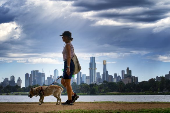
A woman and a dog walk around Albert Park in the warm weather last week.Credit: Luis Enrique Ascui
Moorabbin and Point Cook recorded highs of 40.2 and 40 degrees on Sunday afternoon while Olympic Park recorded a high of 38.6 at 5.11pm, sending many in Melbourne to seek relief at the beaches or other swimming spots.
Mildura, Walpeup, Hopetoun and Warracknabeal all recorded highs of 43 degrees, while Wimmera towns Horsham, Nhill and Edenhope all passed 42 degrees.
Parts of Geelong and Phillip Island were hit hard by storms on Sunday. The SES received hundreds of calls and around 40,000 customers were left without electricity.
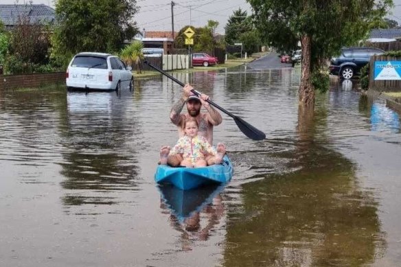
A man and child are seen in a kayak in the streets St Albans Park after Sunday afternoon’s storms.
Thunderstorms, damaging wind and possible hail or localised flash flooding were also forecast for parts of the state’s west, Gippsland and Greater Melbourne.
The SES reported 492 calls to 9pm with many of the calls coming from the Greater Geelong area after flash flooding, hail and winds hit in the late afternoon.
South Barwon (152), Corio (60) and Geelong (56) had the most calls while the suburbs of Belmont and Armstrong Creek were the most affected.
Phillip Island had a number of calls in the late afternoon, with 26 from Ventnor and Cowes while Frankston (16) and Swan Hill (16) also had some issues.
Statewide, 63 calls were for flash flooding, 117 for building damage and 284 for fallen trees.
As of 9.56pm, Ausnet had more than 17,800 customers with power outages across the south-east suburbs and out between Phillip Island and Pakenham plus some in Gippsland, while Powercor listed 18,694 customers with outages, many of them in the Geelong area as of 9.15pm.
One resident of the Geelong suburb of Highton reported marble-sized hail and fierce winds early on Sunday evening, while part of the roof at McDonald Reserve, home of South Barwon Football Club and Highton Cricket Club, was blown off.
The Aaron and Justin Lee verandah is named in memory of two Bali Bombing victims at the ground but was partially blown off in the storms.
Other residents published videos of flooding under the Geelong rail bridge and people driving through floodwaters while one man was photographed paddling a kayak down the street with a child.
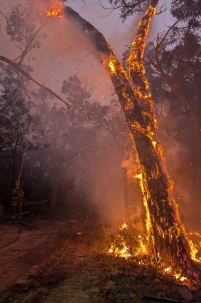
A tree burns during the Yarram Gap Road fire in the Grampians in late December.Credit: State Control Centre
The wild weather won’t bring any long-term cool relief: Melbourne is forecast to reach a top of 39 on Monday and 34 with a cool change developing on Tuesday.
Bureau of Meteorology senior forecaster Lincoln Trainor said the thunderstorms were a “real concern”.
“People need to be a little more careful and aware because those severe thunderstorms later Sunday afternoon and evening around Melbourne have the potential to bring damaging wind gusts and heavy rainfall, which could lead to localised flash flooding,” he said.
Trainor said Victoria was trapped in a northerly airflow, driving the hot temperatures over the state.
“What brings a heatwave is the warmer nights, because you get no reprieve from the heat, which can affect vulnerable people,” he said. “[On Sunday], the minimum is down to 23, and then it’s 25 Monday night.”
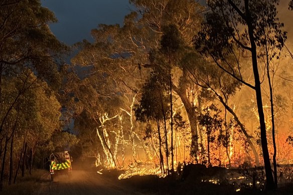
Trees on fire around Wallaby Rocks in the Grampians National Park on Friday.Credit: State Control Centre
The heatwave across Victoria threatens to worsen existing fires in the Grampians as firefighters engage in back-burning to limit the spread.
The Grampians blaze has burnt more than 110,000 hectares since it was ignited on December 17 by dry lightning strikes. Fires spanning about 36,000 hectares are still not under control.
On Sunday morning, a “leave immediately” warning was issued by emergency authorities for Mirranatwa near the Grampians.
The emergency warning was issued about 11am as the fire broke out of the mountainous areas of the Grampians National Park and threatened farmland in the Victoria Valley. The fire was being driven by northerly wind heading towards the area on Sunday morning.
Mirranatwa sits within the northern end of the Victoria Valley, a rich grazing area nestled within two ridges of the mountain range. Some of the finest wool grown in the world comes from large flocks in the area.
VicEmergency warned that the bushfire at Grampians/Gariwerd National Park-Victoria Range was not under control, and was travelling south.
“Leaving immediately is the safest option, before conditions become too dangerous,” the emergency warning said. “Emergency services may not be able to help you if you decide to stay.”
Residents were advised to head towards Dunkeld. An emergency relief centre was available at the Hamilton Arts Centre.
State Control Centre spokesman Luke Hegarty said there were concerns over conditions across the state.
“We know that there’s potential for dry lightning across the state, and given that we had 10,000 strikes on Monday that hit the ground in Victoria, there’s that prospect of something similar happening,” he said.
“Hopefully, we don’t see the winds that we saw on Monday, which means that we might have a chance of getting some crews onto any new fires that we see.”
“The biggest concern we’ve got is the fact that with that heat, we don’t see the cooling-off overnight and not a lot of that moisture recovering. That’s something we would normally rely on, in a way, and that’s just not going to be there over the next few nights. Anything that does get itself established is potentially going to be a challenge over a number of days, just until the weather really backs off.”
The Little Desert Fire, which burnt more than 70,000 hectares near the South Australian border, was under control with one home lost before it broke southern lines on Sunday afternoon.
The Morning Edition newsletter is our guide to the day’s most important and interesting stories, analysis and insights. Sign up here.