
North Queensland weather: Townsville, Ingham in line for thunderstorms, rain
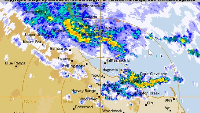
North Queensland is in the “firing line” for significant rainfall totals and thunderstorms, the Bureau of Meteorology cautioned on Sunday.

Townsville
Don't miss out on the headlines from Townsville. Followed categories will be added to My News.
North Queensland is in the “firing line” for significant rainfall totals and thunderstorms, the Bureau of Meteorology cautioned on Sunday.
“We’re looking at a wet few days across northern Queensland in general, I guess you’d say you are back to normal in terms of the wet season,” Senior Meteorologist Felim Hanniffy said.
“There is a risk of some heavy falls at times … that risk is extended more broadly along the north-east tropical coast, which may include areas in the Townsville area down to Bowen and Proserpine.”
Mr Hanniffy said the North could expect a “pretty active week ahead across the tropics in northern Queensland”.
Hinchinbrook Mayor Ramon Jayo warned against complacency on Sunday, saying this morning’s heavy rain was expected to persist for some time.
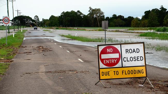
Some rural roads in the flood-battered district had closed to traffic due to pooling surface flooding.
The head of the Local Disaster Management Group said that although no flood or weather warnings had been issued, “our wet season and circumstances can change in a heartbeat”.
“It is always best to be prepared for the unexpected so please make sure your emergency supplies, kits, provisions are always at the ready.”
A minor flood alert has been issued for the Tully River.
Mr Hanniffy said there had been isolated falls of in excess of 200mm over the weekend, with significant rainfall totals to expand more broadly in the coming days.
“For the rest of today and for tomorrow, the risk is probably areas just north of Townsville, so Rollingstone up to around Cooktown, we could see some pockets of falls of up to 200mm or more,” he said.
“And Certainly for Townsville, that risk could increase as we go into Tuesday and Wednesday as well so we couldn’t rule out some isolated falls of 100mm to 200mm.”
Mr Hanniffy said the weather event would mainly be a “coastal” occurrence but some moderate falls could be expected inland, including over river-catchment areas.
“It’s different to the big event we saw in early February when we actually had the full-blown monsoon trough and low as well,” he said.
“This time we don’t have that but we certainly have a lot of moisture around so the risk of heavy falls will persist for a number of days but not to the same calibre that we saw in early-Feb.”

He said Ingham, still attempting to recover from the disaster, would also be in the “firing line”.
“Certainly you could get some daily falls of 200mm plus in the coming days as well … it doesn’t take much to get up to 200mm … if you are getting 10mm an hour for 24 hours, it ticks up to 240mm pretty easy, just steady rather than any intense falls.”
Mr Hanniffy said another watch point was the potential for localised thunderstorms throughout the North, particularly from Townsville to Ingham overnight Sunday, Monday morning and on Tuesday.
He said that although norther river catchments had been allowed to dry, “still remain underlyingly wet”.
“With the increased rainfall we are likely to see some of those (catchments), particularly in the more coastal river systems, start to respond as well … river systems may start to flow into some localised flooding.”
More Coverage


Originally published as North Queensland weather: Townsville, Ingham in line for thunderstorms, rain

In pictures: International Women’s Day function at The Ville
The Townsnville Business Women’s Circle celebrated International Women’s Day with a vibrant event featuring a panel discusssion from local business identities Jayne Arlett, Michelle Morton and Debbie Rains.

‘Long time coming’: Industry meets Defence in historic visit
Defence industry experts got up close and personal with the latest military hardware and training facilities during a ‘Defence Day tour of Lavarack Barracks last week.